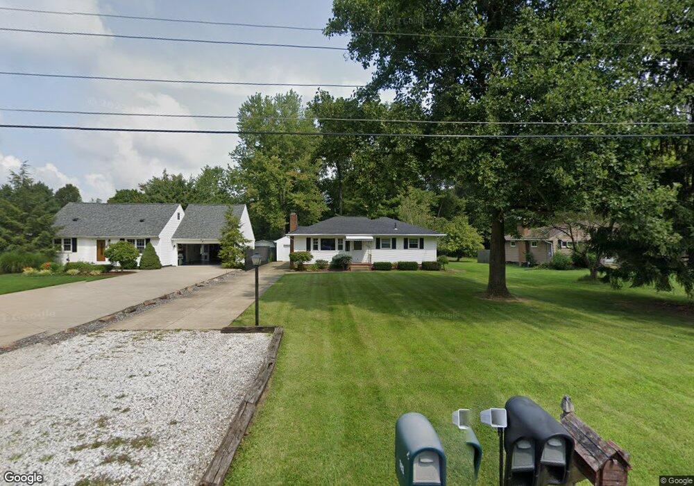
391 Maplewood Dr Alliance, OH 44601
Estimated Value: $218,312 - $255,000
3
Beds
2
Baths
1,217
Sq Ft
$190/Sq Ft
Est. Value
About This Home
This home is located at 391 Maplewood Dr, Alliance, OH 44601 and is currently estimated at $231,828, approximately $190 per square foot. 391 Maplewood Dr is a home located in Stark County with nearby schools including Alliance Elementary School at Rockhill, Alliance Intermediate School at Northside, and Alliance Middle School.
Ownership History
Date
Name
Owned For
Owner Type
Purchase Details
Closed on
Dec 16, 2011
Sold by
Brueske Brenda C
Bought by
Rebh Adam P
Current Estimated Value
Home Financials for this Owner
Home Financials are based on the most recent Mortgage that was taken out on this home.
Original Mortgage
$95,416
Outstanding Balance
$65,208
Interest Rate
3.99%
Mortgage Type
New Conventional
Estimated Equity
$166,620
Purchase Details
Closed on
Aug 10, 2009
Sold by
Brueske Charles H and Brueske Brenda C
Bought by
Brueske Brenda C and The Brenda C Brueske Revocable Trust
Create a Home Valuation Report for This Property
The Home Valuation Report is an in-depth analysis detailing your home's value as well as a comparison with similar homes in the area
Home Values in the Area
Average Home Value in this Area
Purchase History
| Date | Buyer | Sale Price | Title Company |
|---|---|---|---|
| Rebh Adam P | -- | None Available | |
| Brueske Brenda C | -- | None Available |
Source: Public Records
Mortgage History
| Date | Status | Borrower | Loan Amount |
|---|---|---|---|
| Open | Rebh Adam P | $95,416 |
Source: Public Records
Tax History Compared to Growth
Tax History
| Year | Tax Paid | Tax Assessment Tax Assessment Total Assessment is a certain percentage of the fair market value that is determined by local assessors to be the total taxable value of land and additions on the property. | Land | Improvement |
|---|---|---|---|---|
| 2025 | -- | $66,160 | $11,170 | $54,990 |
| 2024 | -- | $66,160 | $11,170 | $54,990 |
| 2023 | $1,612 | $40,120 | $9,560 | $30,560 |
| 2022 | $1,623 | $40,120 | $9,560 | $30,560 |
| 2021 | $1,624 | $40,120 | $9,560 | $30,560 |
| 2020 | $1,480 | $34,130 | $8,300 | $25,830 |
| 2019 | $1,459 | $34,140 | $8,300 | $25,840 |
| 2018 | $1,466 | $34,140 | $8,300 | $25,840 |
| 2017 | $1,378 | $31,580 | $6,970 | $24,610 |
| 2016 | $1,389 | $31,580 | $6,970 | $24,610 |
| 2015 | $1,402 | $31,580 | $6,970 | $24,610 |
| 2014 | $1,555 | $33,360 | $7,350 | $26,010 |
| 2013 | $776 | $33,360 | $7,350 | $26,010 |
Source: Public Records
Map
Nearby Homes
- 2705 Shunk Ave
- 2839 S Rockhill Ave
- 3101 Ridgehill Ave
- 1059 Oakwood Dr
- 236 E Milton St
- 2460 S Arch Ave
- 277 W Carol St
- 2408 S Linden Ave
- 555 E Milton St
- 884 W College Rd
- 317 E State St
- 2218 S Freedom Ave
- 1325 W Beech St
- 2195 Blenheim Ave
- 2376 S Seneca Ave
- 2112 Blenheim Ave
- 3709 S Union Ave
- 112 E College St
- 1515 S Rockhill Ave
- 2220 Western Ave
- 399 Maplewood Dr
- 379 Maplewood Dr
- 415 Maplewood Dr
- 367 Maplewood Dr
- 429 Maplewood Dr
- 392 Maplewood Dr
- 392 Maplewood Dr
- 416 Maplewood Dr
- 336 Maplewood Dr
- 336 Maplewood Dr
- 420 Maplewood Dr
- 345 Maplewood Dr
- 445 Maplewood Dr
- 2740 Shunk Ave
- 2812 Belleflower Dr
- 325 Maplewood Dr
- 340 Maplewood Dr
- 2729 Shunk Ave
- 2724 Shunk Ave
- 387 Linwood Dr