


PENDING
$40K PRICE DROP
391 W 370 S American Fork, UT 84003
Estimated payment $3,372/month
Total Views
14,438
5
Beds
3
Baths
2,890
Sq Ft
$207
Price per Sq Ft
Highlights
- Home Theater
- Updated Kitchen
- Private Lot
- RV or Boat Parking
- Fruit Trees
- Vaulted Ceiling
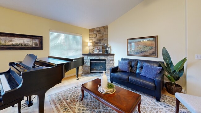
About This Home
Enjoy the garden-to-table life in American Fork, just steps from Monarch Park and the 40-acre forested butterfly habitat, With $100K+ in upgrades, this peaceful, fully fenced retreat blends spacious living with city convenience. All the work is done-just move in and enjoy. Ask your Realtor for the full upgrade list attached to this listing. Interior highlights include main-level living with the primary suite, 2 secondary bedrooms, laundry, and kitchen all on the main floor. The chef's kitchen features expansive counters, generous cabinets, a new high-end dishwasher, and a professional-grade vented hood. The spa-like primary bath offers a large jetted tub with a dedicated 50-gallon hot water heater. The finished basement includes a theater/great room, workout room, and a removable utility ceiling. This home features a newer furnace and AC (4 years), new water heater (2 years), and an EV charger in the garage (negotiable). Hardwood floors are lifetime refinishing capable, and exceptional soundproofing keeps upstairs and downstairs spaces quiet and private. Outdoor features include a fully fenced private yard with mature fruit trees-cherry, peach, nectarine, and apple-plus raised garden beds. The garden produces kale, mint, squash, cucumbers, and tomatoes. RV parking is available in a 15'9" x 49'3" side yard which is large enough for a boat, trailer or a 10-ton soil delivery (yes, that has been done!). Recent upgrades include a new graded lawn, reinforced cement walk (2 months old), lifetime-wrapped back door frame, and a durable garden box. Location perks include being only 10 minutes from Costco, Walmart, Macey's, shopping, and dining. The home is just steps away from a scenic forest trail and city park. It is part of a friendly small-town community known for its nationally ranked marching band and top-rated hospital. Nearby are Art Dye Park, pickle ball courts, the Murdock Trail, American Fork Canyon, Alpine Loop, and Sundance. Whether you're relaxing in the jetted tub, on the back patio or enjoying nearby trails, this home offers a peaceful lifestyle that will make you glad to be home.
Listing Agent
Utah Key Real Estate, LLC (Woodhaven Branch) License #12691428 Listed on: 08/19/2025
Home Details
Home Type
- Single Family
Est. Annual Taxes
- $2,353
Year Built
- Built in 2003
Lot Details
- 7,841 Sq Ft Lot
- Property is Fully Fenced
- Landscaped
- Private Lot
- Fruit Trees
- Mature Trees
- Pine Trees
- Vegetable Garden
- Property is zoned Single-Family
Parking
- 2 Car Attached Garage
- 4 Open Parking Spaces
- RV or Boat Parking
Home Design
- Rambler Architecture
- Stone Siding
- Asphalt
- Stucco
Interior Spaces
- 2,890 Sq Ft Home
- 2-Story Property
- Vaulted Ceiling
- Ceiling Fan
- Gas Log Fireplace
- Double Pane Windows
- Blinds
- Great Room
- Home Theater
- Basement Fills Entire Space Under The House
- Dryer
Kitchen
- Updated Kitchen
- Gas Oven
- Down Draft Cooktop
- Range Hood
- Microwave
- Granite Countertops
- Disposal
Flooring
- Wood
- Carpet
- Tile
Bedrooms and Bathrooms
- 5 Bedrooms | 3 Main Level Bedrooms
- Primary Bedroom on Main
- Walk-In Closet
- 3 Full Bathrooms
- Hydromassage or Jetted Bathtub
Eco-Friendly Details
- Solar owned by seller
- Heating system powered by active solar
- Sprinkler System
Outdoor Features
- Open Patio
Schools
- Greenwood Elementary School
- American Fork Middle School
- American Fork High School
Utilities
- Central Heating and Cooling System
- Natural Gas Connected
Community Details
- No Home Owners Association
- Plat G Mountain Meadows Pud Subdivision
- Electric Vehicle Charging Station
Listing and Financial Details
- Assessor Parcel Number 46-595-0018
Map
Create a Home Valuation Report for This Property
The Home Valuation Report is an in-depth analysis detailing your home's value as well as a comparison with similar homes in the area
Home Values in the Area
Average Home Value in this Area
Tax History
| Year | Tax Paid | Tax Assessment Tax Assessment Total Assessment is a certain percentage of the fair market value that is determined by local assessors to be the total taxable value of land and additions on the property. | Land | Improvement |
|---|---|---|---|---|
| 2025 | $2,353 | $513,500 | $195,200 | $318,300 |
| 2024 | $2,353 | $261,470 | $0 | $0 |
| 2023 | $2,241 | $263,945 | $0 | $0 |
| 2022 | $2,340 | $272,030 | $0 | $0 |
| 2021 | $1,980 | $359,500 | $122,500 | $237,000 |
| 2020 | $1,867 | $328,800 | $109,400 | $219,400 |
| 2019 | $1,749 | $318,600 | $99,200 | $219,400 |
| 2018 | $1,626 | $283,100 | $92,300 | $190,800 |
| 2017 | $1,471 | $138,270 | $0 | $0 |
| 2016 | $1,514 | $132,220 | $0 | $0 |
| 2015 | $1,436 | $119,020 | $0 | $0 |
| 2014 | $1,356 | $110,825 | $0 | $0 |
Source: Public Records
Property History
| Date | Event | Price | Change | Sq Ft Price |
|---|---|---|---|---|
| 09/28/2025 09/28/25 | Pending | -- | -- | -- |
| 09/23/2025 09/23/25 | Price Changed | $599,000 | -3.2% | $207 / Sq Ft |
| 09/01/2025 09/01/25 | Price Changed | $619,000 | -3.1% | $214 / Sq Ft |
| 08/19/2025 08/19/25 | For Sale | $639,000 | -- | $221 / Sq Ft |
Source: UtahRealEstate.com
Purchase History
| Date | Type | Sale Price | Title Company |
|---|---|---|---|
| Warranty Deed | -- | Highland Title | |
| Warranty Deed | -- | Provo Land Title Company |
Source: Public Records
Mortgage History
| Date | Status | Loan Amount | Loan Type |
|---|---|---|---|
| Open | $226,700 | New Conventional | |
| Previous Owner | $140,900 | Purchase Money Mortgage | |
| Closed | $25,000 | No Value Available |
Source: Public Records
About the Listing Agent
My 27 years in business as a marketing expert, 9 years specifically in Real Estate, I have learned that above all, clients want to work with someone who cares, who puts in full effort, and who is highly capable. I work to earn this reputation with my clients every single day. Give me a call and let's plan your next move in Real Estate. I look forward to the opportunity to earn your business.
Melinda's Other Listings
Source: UtahRealEstate.com
MLS Number: 2106109
APN: 46-595-0018
Disclaimer: Certain information contained herein is derived from information provided by parties other than Homes.com. All information provided is deemed reliable, but is not guaranteed to be accurate and should be independently verified.
![]() IDX information is provided exclusively for consumers’ personal, non-commercial use, that it may not be used for any purpose other than to identify prospective properties consumers may be interested in purchasing, and that the data is deemed reliable but is not guaranteed accurate by the MLS. Licensor is only providing the MLS Content and not other sources of data provided in the Product.
IDX information is provided exclusively for consumers’ personal, non-commercial use, that it may not be used for any purpose other than to identify prospective properties consumers may be interested in purchasing, and that the data is deemed reliable but is not guaranteed accurate by the MLS. Licensor is only providing the MLS Content and not other sources of data provided in the Product.
Based on information from the Wasatch Front Regional Multiple Listing Service, Inc.. All data, including all measurements and calculations of area, is obtained from various sources and has not been, and will not be, verified by broker or the MLS. All information should be independently reviewed and verified for accuracy. Properties may or may not be listed by the office/agent presenting the information.
Nearby Homes
- 365 W 370 S
- 466 S 300 W
- 429 S Storrs Ave
- 271 S Barratt Cir
- 217 W 380 S
- 386 S Storrs Ct Unit 103
- Juniper Plan at Storrs Court
- Evergreen Plan at Storrs Court
- Redwood Plan at Storrs Court
- Ashwood Plan at Storrs Court
- 368 S Storrs Ct Unit 107
- 354 S 650 W
- 415 S 680 W Unit 45
- 82 S Lincoln Ave
- 79 S Lincoln Ave
- 376 S 700 W
- 721 W Crystal Creek Rd
- 217 W Main St
- 468 S 740 W
- 753 W Crystal Creek Rd