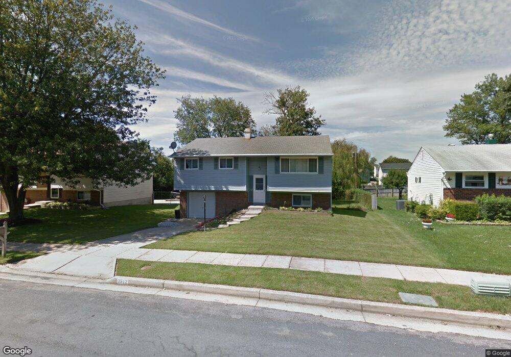
3912 Nemo Rd Randallstown, MD 21133
Estimated Value: $295,000 - $348,647
3
Beds
2
Baths
1,062
Sq Ft
$303/Sq Ft
Est. Value
About This Home
This home is located at 3912 Nemo Rd, Randallstown, MD 21133 and is currently estimated at $322,162, approximately $303 per square foot. 3912 Nemo Rd is a home located in Baltimore County with nearby schools including Winand Elementary School, Northwest Academy of Health Sciences, and Randallstown High School.
Ownership History
Date
Name
Owned For
Owner Type
Purchase Details
Closed on
Sep 30, 2024
Sold by
Abiodun Victoria Folake and Abiodun Olukayode
Bought by
Glorietta Llc
Current Estimated Value
Purchase Details
Closed on
Feb 24, 2009
Sold by
Benton David A
Bought by
Abiodun Olukayode and Abiodun Victoria
Purchase Details
Closed on
Dec 23, 1992
Sold by
Cohen Lee R
Bought by
Benton David A
Create a Home Valuation Report for This Property
The Home Valuation Report is an in-depth analysis detailing your home's value as well as a comparison with similar homes in the area
Home Values in the Area
Average Home Value in this Area
Purchase History
| Date | Buyer | Sale Price | Title Company |
|---|---|---|---|
| Glorietta Llc | -- | None Listed On Document | |
| Glorietta Llc | -- | None Listed On Document | |
| Abiodun Olukayode | $165,000 | -- | |
| Benton David A | $95,900 | -- |
Source: Public Records
Tax History
| Year | Tax Paid | Tax Assessment Tax Assessment Total Assessment is a certain percentage of the fair market value that is determined by local assessors to be the total taxable value of land and additions on the property. | Land | Improvement |
|---|---|---|---|---|
| 2025 | $3,924 | $264,500 | -- | -- |
| 2024 | $3,924 | $249,700 | $73,700 | $176,000 |
| 2023 | $3,547 | $235,067 | $0 | $0 |
| 2022 | $3,365 | $220,433 | $0 | $0 |
| 2021 | $3,254 | $205,800 | $55,700 | $150,100 |
| 2020 | $3,254 | $199,167 | $0 | $0 |
| 2019 | $3,497 | $192,533 | $0 | $0 |
| 2018 | $2,949 | $185,900 | $55,700 | $130,200 |
| 2017 | $2,911 | $172,700 | $0 | $0 |
| 2016 | $2,968 | $159,500 | $0 | $0 |
| 2015 | $2,968 | $146,300 | $0 | $0 |
| 2014 | $2,968 | $146,300 | $0 | $0 |
Source: Public Records
Map
Nearby Homes
- 8829 Sigrid Rd
- 4048 Carthage Rd
- 9063 Meadow Heights Rd
- 8541 Lucerne Rd
- 4226 Huntshire Rd
- 1205/99 Winands Rd
- 8604 Woodbrook Ct
- 3723 Eastman Rd
- 9202 Samoset Rd
- 3506 Bayer Ave
- 4228 Brookside Oaks
- 8513 Charlton Rd
- 8809 Stone Ridge Cir Unit 204
- 8807 Stone Ridge Cir Unit 101
- 8811 Stoneridge Cir Unit 103
- 9208A Liberty Rd
- 4816 Valley Forge Rd
- 4818 Oakland Park Rd
- 8905 Stone Creek Place Unit 201
- 9129 Marlove Oaks Ln
Your Personal Tour Guide
Ask me questions while you tour the home.