Estimated Value: $331,322 - $387,000
3
Beds
3
Baths
1,920
Sq Ft
$182/Sq Ft
Est. Value
About This Home
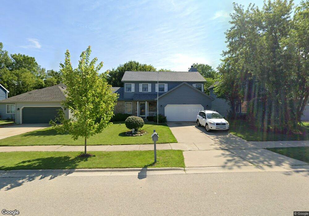
This home is located at 3913 Bertrand Ln, Zion, IL 60099 and is currently estimated at $348,581, approximately $181 per square foot. 3913 Bertrand Ln is a home located in Lake County with nearby schools including Howe Elementary School, Beach Park Middle School, and Zion-Benton Township High School.
Ownership History
Date
Name
Owned For
Owner Type
Purchase Details
Closed on
Dec 6, 1994
Sold by
Grand National Bank
Bought by
Drysdale Brandon R and Drysdale Pamela S
Current Estimated Value
Home Financials for this Owner
Home Financials are based on the most recent Mortgage that was taken out on this home.
Original Mortgage
$137,700
Interest Rate
9.19%
Create a Home Valuation Report for This Property
The Home Valuation Report is an in-depth analysis detailing your home's value as well as a comparison with similar homes in the area
Home Values in the Area
Average Home Value in this Area
Purchase History
| Date | Buyer | Sale Price | Title Company |
|---|---|---|---|
| Drysdale Brandon R | $153,000 | Intercounty Title |
Source: Public Records
Mortgage History
| Date | Status | Borrower | Loan Amount |
|---|---|---|---|
| Closed | Drysdale Brandon R | $137,700 |
Source: Public Records
Tax History Compared to Growth
Tax History
| Year | Tax Paid | Tax Assessment Tax Assessment Total Assessment is a certain percentage of the fair market value that is determined by local assessors to be the total taxable value of land and additions on the property. | Land | Improvement |
|---|---|---|---|---|
| 2024 | $8,409 | $85,863 | $5,703 | $80,160 |
| 2023 | $8,528 | $75,072 | $5,505 | $69,567 |
| 2022 | $8,528 | $72,622 | $5,378 | $67,244 |
| 2021 | $8,798 | $70,775 | $5,241 | $65,534 |
| 2020 | $8,639 | $67,539 | $5,001 | $62,538 |
| 2019 | $8,621 | $64,079 | $4,745 | $59,334 |
| 2018 | $8,565 | $61,855 | $5,656 | $56,199 |
| 2017 | $8,466 | $58,189 | $5,321 | $52,868 |
| 2016 | $8,268 | $55,397 | $5,066 | $50,331 |
| 2015 | $8,017 | $50,804 | $4,646 | $46,158 |
| 2014 | $8,266 | $54,376 | $12,480 | $41,896 |
| 2012 | $8,295 | $56,506 | $12,969 | $43,537 |
Source: Public Records
Map
Nearby Homes
- 3931 Bertrand Ln
- 1121 Otto Graham Ln
- 38571 N Cedar Ave
- 10765 W Liberty Ave
- 1667 W Beach Rd Unit 1667
- 1677 W Beach Rd Unit 1677
- 11345 W Carnahan Ave
- 11382 W Leland Ave
- 38362 N Manor Ave
- 38176 N De Woody Rd
- 38683 N Lewis Ave
- 1730 W Beach Rd
- 10295 W Crissy Ave
- 10209 W Crissy Ave
- 11342-11346 W Wadsworth Rd
- 10381 Country Ln
- 38402 N Russell Ave
- 10156 W Beach Rd
- 37905 N Loyola Ave
- 39161 N Holdridge Ave
- 3915 Bertrand Ln
- 3909 Bertrand Ln
- 3905 Bertrand Ln
- 3919 Bertrand Ln
- 1111 Pine St Unit TEN
- 1111 Ten Pin Ln
- 10865 W Chaney Ave
- 3923 Bertrand Ln
- 3901 Bertrand Ln
- 1110 Bob Ofarrell Ln
- 1115 Pine St Unit TEN
- 1115 10 Pin Ln
- 3927 Bertrand Ln
- 3833 Bertrand Ln
- 1114 Bob Ofarrell Ln
- 1112 Pine St Unit TEN
- 1119 Ten Pin Ln
- 1119 10 Pin Ln
- 1118 Bob Ofarrell Ln
- 1116 Pine St Unit TEN