3917 Colony Pointe Dr Chesapeake, VA 23321
Western Branch NeighborhoodEstimated Value: $539,000 - $622,000
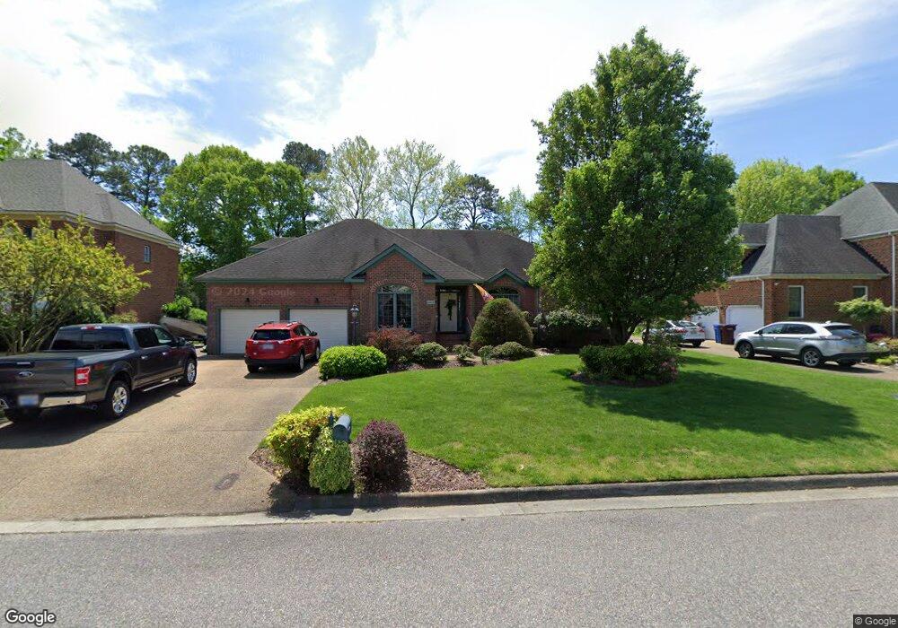
About This Home
This home is located at 3917 Colony Pointe Dr, Chesapeake, VA 23321 and is currently estimated at $565,508, approximately $212 per square foot. 3917 Colony Pointe Dr is a home located in Chesapeake City with nearby schools including Edwin W. Chittum Elementary School, Jolliff Middle School, and Western Branch High School.
Ownership History
We collect this data history from publicly available records. To have your information removed, we recommend requesting removal directly through your county’s website.
Purchase Details
Home Values in the Area
Average Home Value in this Area
Purchase History
We collect this data history from publicly available records. To have your information removed, we recommend requesting removal directly through your county’s website.
| Date | Buyer | Sale Price | Title Company |
|---|---|---|---|
| -- | None Available |
Tax History
We collect this data history from publicly available records. To have your information removed, we recommend requesting removal directly through your county’s website.
| Year | Tax Paid | Tax Assessment Tax Assessment Total Assessment is a certain percentage of the fair market value that is determined by local assessors to be the total taxable value of land and additions on the property. | Land | Improvement |
|---|---|---|---|---|
| 2025 | $4,939 | $489,000 | $165,000 | $324,000 |
| 2024 | $5,005 | $495,500 | $160,000 | $335,500 |
| 2023 | $4,466 | $468,300 | $150,000 | $318,300 |
| 2022 | $4,601 | $455,500 | $150,000 | $305,500 |
| 2021 | $3,864 | $374,500 | $120,000 | $254,500 |
| 2020 | $3,841 | $365,800 | $120,000 | $245,800 |
| 2019 | $3,841 | $365,800 | $120,000 | $245,800 |
| 2018 | $3,710 | $353,400 | $115,000 | $238,400 |
| 2017 | $3,711 | $353,400 | $115,000 | $238,400 |
| 2016 | $3,711 | $353,400 | $115,000 | $238,400 |
| 2015 | $3,789 | $360,900 | $120,000 | $240,900 |
| 2014 | $3,688 | $351,200 | $120,000 | $231,200 |
Map
- 3932 Colony Pointe Dr
- 1875 Ames Cir W
- 4267 White Cap Crest
- 4028 Scotfield Dr
- 4100 Scotfield Dr
- 4125 Taughtline Loop
- 4200 Quailshire Ct
- 4999 Clifton St
- 4609 Longleaf Place
- 4904 Apricot Way
- MM the Grove (Laurel)
- MM Myrtle II
- 4906 Apricot Way
- 4910 Apricot Way
- 4900 Apricot Way
- 1920 Ames Cir W
- 4061 Holly Cove Dr
- 4209 Quailshire Ct
- 4032 Sloop Trail
- 3860 Schooner Trail
- 3913 Colony Pointe Dr
- 3921 Colony Pointe Dr
- 3925 Colony Pointe Dr
- 3916 Colony Pointe Dr
- 3909 Colony Pointe Dr
- 3920 Colony Pointe Dr
- 3912 Colony Pointe Dr
- 3924 Colony Pointe Dr
- 3908 Colony Pointe Dr
- 3929 Colony Pointe Dr
- 3905 Colony Pointe Dr
- 3928 Colony Pointe Dr
- 3933 Colony Pointe Dr
- 1813 Dock Landing Rd
- 1733 Dock Landing Rd
- 3905 Whites Landing
- 1807 Dock Landing Rd
- 3936 Colony Pointe Dr
- 3909 Whites Landing
- 3833 Whites Landing
Ask me questions while you tour the home.