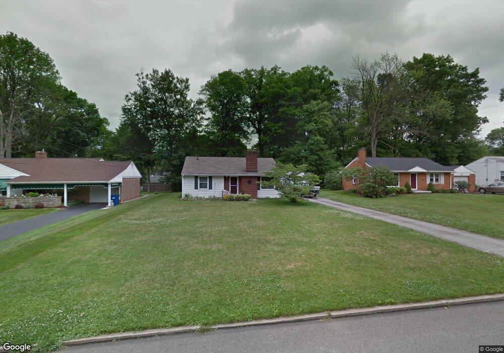
3917 Dover Rd Youngstown, OH 44511
Estimated Value: $120,000 - $154,000
3
Beds
1
Bath
994
Sq Ft
$141/Sq Ft
Est. Value
About This Home
This home is located at 3917 Dover Rd, Youngstown, OH 44511 and is currently estimated at $139,678, approximately $140 per square foot. 3917 Dover Rd is a home located in Mahoning County with nearby schools including West Boulevard Elementary School, Boardman Center Middle School, and Boardman High School.
Ownership History
Date
Name
Owned For
Owner Type
Purchase Details
Closed on
Sep 17, 2001
Sold by
Prystash Charles F Prystash Peggy R
Bought by
Rutledge Michael E
Current Estimated Value
Home Financials for this Owner
Home Financials are based on the most recent Mortgage that was taken out on this home.
Original Mortgage
$78,271
Outstanding Balance
$29,096
Interest Rate
6.97%
Mortgage Type
FHA
Estimated Equity
$110,582
Purchase Details
Closed on
Aug 23, 1994
Bought by
Kikel Josephine
Purchase Details
Closed on
Sep 8, 1988
Bought by
Kikel Josephine
Create a Home Valuation Report for This Property
The Home Valuation Report is an in-depth analysis detailing your home's value as well as a comparison with similar homes in the area
Home Values in the Area
Average Home Value in this Area
Purchase History
We collect this data history from publicly available records. To have your information removed, we recommend requesting removal directly through your county’s website.
| Date | Buyer | Sale Price | Title Company |
|---|---|---|---|
| Rutledge Michael E | $79,500 | -- | |
| Kikel Josephine | $69,000 | -- | |
| Kikel Josephine | -- | -- |
Source: Public Records
Mortgage History
We collect this data history from publicly available records. To have your information removed, we recommend requesting removal directly through your county’s website.
| Date | Status | Borrower | Loan Amount |
|---|---|---|---|
| Open | Rutledge Michael E | $78,271 |
Source: Public Records
Tax History
| Year | Tax Paid | Tax Assessment Tax Assessment Total Assessment is a certain percentage of the fair market value that is determined by local assessors to be the total taxable value of land and additions on the property. | Land | Improvement |
|---|---|---|---|---|
| 2025 | $1,898 | $38,060 | $6,970 | $31,090 |
| 2024 | $1,942 | $38,060 | $6,970 | $31,090 |
| 2023 | $1,916 | $38,060 | $6,970 | $31,090 |
| 2022 | $1,371 | $20,660 | $6,730 | $13,930 |
| 2021 | $1,372 | $20,660 | $6,730 | $13,930 |
| 2020 | $1,379 | $20,660 | $6,730 | $13,930 |
| 2019 | $1,410 | $18,610 | $6,060 | $12,550 |
| 2018 | $1,183 | $18,610 | $6,060 | $12,550 |
| 2017 | $1,253 | $18,610 | $6,060 | $12,550 |
| 2016 | $1,327 | $20,740 | $6,060 | $14,680 |
| 2015 | $1,301 | $20,740 | $6,060 | $14,680 |
| 2014 | $1,304 | $20,740 | $6,060 | $14,680 |
| 2013 | $1,288 | $20,740 | $6,060 | $14,680 |
Source: Public Records
Map
Nearby Homes
- 3648 Glenmere Dr
- 3539 Kiowa Dr
- 3530 Glenmere Dr
- 4047 Cascade Dr
- 4020 Stratmore Ave
- 1564 Cascade Dr
- 3435 Hopkins Rd
- 48 Lake Shore Dr
- 4013 Hopkins Rd
- 944 Canfield Rd
- 966 Lanterman Ave
- 2002 Canfield Rd
- 40 Gillian Ln
- 3289 Cricket Dr
- 966 Bonnie Brae Ave
- 3296 Cricket Dr
- 836 Canfield Rd
- 3781 Baymar Dr
- 4207 Stratford Rd
- 4661 Lockwood Blvd
Your Personal Tour Guide
Ask me questions while you tour the home.