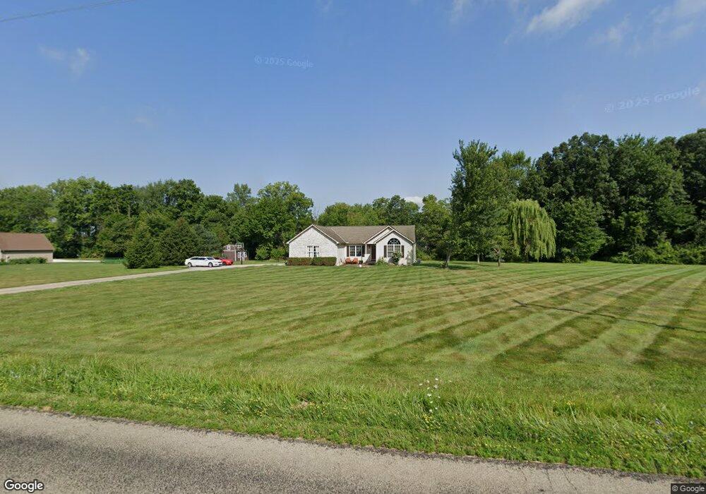
3917 Johnstown Rd Centerburg, OH 43011
Estimated Value: $431,019 - $483,000
3
Beds
2
Baths
1,830
Sq Ft
$243/Sq Ft
Est. Value
About This Home
This home is located at 3917 Johnstown Rd, Centerburg, OH 43011 and is currently estimated at $444,755, approximately $243 per square foot. 3917 Johnstown Rd is a home located in Knox County with nearby schools including Centerburg Elementary School and Centerburg High School.
Ownership History
Date
Name
Owned For
Owner Type
Purchase Details
Closed on
May 8, 2008
Sold by
Rusmisel Thad and Rusmisel Sarah
Bought by
Christy Sawn T and Christy Kellie C
Current Estimated Value
Purchase Details
Closed on
Dec 3, 2004
Sold by
Parsons Robert A and Parsons Beth A
Bought by
Rusmisel Thad and Rusmisel Sarah
Purchase Details
Closed on
May 26, 2004
Sold by
Shellenbarger Cliff and Shellenbarger Che
Bought by
Parsons Robert A and Parsons Beth A
Purchase Details
Closed on
Apr 8, 2003
Sold by
Heath Paul E
Bought by
Heath Paul E
Create a Home Valuation Report for This Property
The Home Valuation Report is an in-depth analysis detailing your home's value as well as a comparison with similar homes in the area
Home Values in the Area
Average Home Value in this Area
Purchase History
| Date | Buyer | Sale Price | Title Company |
|---|---|---|---|
| Christy Sawn T | $14,925 | None Available | |
| Rusmisel Thad | $189,300 | -- | |
| Parsons Robert A | $69,000 | -- | |
| Heath Paul E | -- | -- |
Source: Public Records
Tax History Compared to Growth
Tax History
| Year | Tax Paid | Tax Assessment Tax Assessment Total Assessment is a certain percentage of the fair market value that is determined by local assessors to be the total taxable value of land and additions on the property. | Land | Improvement |
|---|---|---|---|---|
| 2024 | $4,407 | $109,700 | $19,080 | $90,620 |
| 2023 | $4,407 | $109,700 | $19,080 | $90,620 |
| 2022 | $3,906 | $83,740 | $14,560 | $69,180 |
| 2021 | $3,906 | $83,740 | $14,560 | $69,180 |
| 2020 | $3,563 | $83,740 | $14,560 | $69,180 |
| 2019 | $3,145 | $68,240 | $13,230 | $55,010 |
| 2018 | $3,153 | $68,240 | $13,230 | $55,010 |
| 2017 | $2,889 | $68,240 | $13,230 | $55,010 |
| 2016 | $2,652 | $63,180 | $12,250 | $50,930 |
| 2015 | $2,533 | $63,180 | $12,250 | $50,930 |
| 2014 | $2,530 | $63,180 | $12,250 | $50,930 |
| 2013 | $2,555 | $60,650 | $11,520 | $49,130 |
Source: Public Records
Map
Nearby Homes
- 3959 Johnstown Rd
- 0 Johnstown Rd Unit Sec 13, Tract 5
- 0 Johnstown Rd Unit 20250514
- 4682 Webster Rd
- 0 Johnstown Rd Unit 225026692
- 5679 White Rd
- 9470 Butcher Rd
- 0 Larimore Rd
- 9730 Butcher Rd
- 9240 Sycamore Rd
- 0 Krause Rd Unit 225038328
- 4453 Cardan Ln
- 7106 Columbus Rd
- 7225 Columbus Rd
- 001 Marion Rd NW
- 357 S Hartford Ave
- 7559 Tucker Rd
- 436 Ohio 314
- 7020 Bennington Chapel Rd
- 170 S Preston St
- 3859 Johnstown Rd
- 4024 Johnstown Rd
- 3841 Johnstown Rd
- 4033 Johnstown Rd
- 3922 Johnstown Rd
- 3842 Johnstown Rd
- 3739 Johnstown Rd
- 4077 Johnstown Rd
- 3740 Johnstown Rd
- 4134 Johnstown Rd
- 3791 Simmons Church Rd
- 3660 Simmons Church Rd
- 4229 Simmons Church Rd
- 4178 Johnstown Rd
- 3617 Johnstown Rd
- 3541 Johnstown Rd
- 3463 Simmons Church Rd
- 3600 Johnstown Rd
- 4300 Johnstown Rd
- 3399 Simmons Church Rd