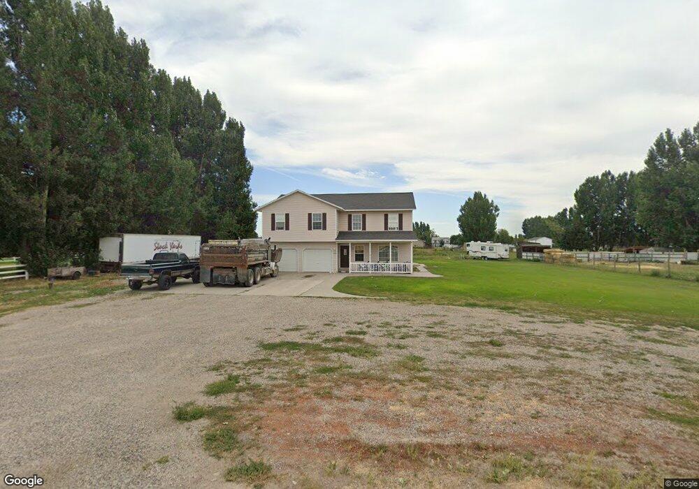
3919 W 1000 S Rexburg, ID 83440
Estimated Value: $475,757 - $722,000
4
Beds
3
Baths
2,404
Sq Ft
$245/Sq Ft
Est. Value
About This Home
This home is located at 3919 W 1000 S, Rexburg, ID 83440 and is currently estimated at $587,939, approximately $244 per square foot. 3919 W 1000 S is a home located in Madison County with nearby schools including Burton Elementary School, Kennedy Elementary School, and Madison Junior High School.
Ownership History
Date
Name
Owned For
Owner Type
Purchase Details
Closed on
Sep 19, 2025
Sold by
Flanary Bryce and Flanary Teresa
Bought by
Flanary Kevin L and Flanary Mary
Current Estimated Value
Purchase Details
Closed on
Jun 9, 2022
Sold by
Breckenridge Property Fund 2016 Llc
Bought by
Flanary Kevin L and Flanary Mary
Purchase Details
Closed on
Dec 7, 2021
Sold by
Flanary Kevin L
Bought by
Breckenridge Property Fund 2016 Llc
Create a Home Valuation Report for This Property
The Home Valuation Report is an in-depth analysis detailing your home's value as well as a comparison with similar homes in the area
Home Values in the Area
Average Home Value in this Area
Purchase History
| Date | Buyer | Sale Price | Title Company |
|---|---|---|---|
| Flanary Kevin L | -- | Flying S Title And Escrow | |
| Flanary Kevin L | -- | First American Title | |
| Breckenridge Property Fund 2016 Llc | -- | None Available |
Source: Public Records
Tax History Compared to Growth
Tax History
| Year | Tax Paid | Tax Assessment Tax Assessment Total Assessment is a certain percentage of the fair market value that is determined by local assessors to be the total taxable value of land and additions on the property. | Land | Improvement |
|---|---|---|---|---|
| 2025 | $2,598 | $385,599 | $80,000 | $305,599 |
| 2024 | $2,598 | $385,599 | $80,000 | $305,599 |
| 2023 | $2,598 | $356,167 | $60,000 | $296,167 |
| 2022 | $3,346 | $331,736 | $45,000 | $286,736 |
| 2021 | $1,791 | $273,289 | $37,000 | $236,289 |
| 2020 | $1,644 | $229,434 | $37,000 | $192,434 |
| 2019 | $1,541 | $211,213 | $37,000 | $174,213 |
| 2018 | $1,350 | $193,616 | $37,000 | $156,616 |
| 2017 | $2,611 | $184,817 | $37,000 | $147,817 |
| 2016 | $2,621 | $189,809 | $37,000 | $152,809 |
| 2015 | $2,373 | $171,618 | $0 | $0 |
| 2013 | -- | $171,618 | $0 | $0 |
Source: Public Records
Map
Nearby Homes
- 3910 Wagon Trail Rd
- L8B2 Debbie Ln
- L7B2 Debbie Ln
- TBD S 4000 W
- L6B2 Debbie Ln
- L5B2 Debbie Ln
- 231 S 3421 W
- Tract 3 S 4000 W
- L4B2 Debbie Ln
- L3B2 Debbie Ln
- L3B1 Debbie Ln
- L2B2 Debbie Ln
- L2B1 Debbie Ln
- L1B2 Debbie Ln
- L1B1 Debbie Ln
- TBD S40 S 5000 W
- TBD N40 S 5000 W
- 264 S 5000 W
- 140 S 5000 W
- 2495 W 960 S
- 1025 Desert Rock Dr
- 1025 S Desert Rock Rd
- 3967 W 1000 S
- 1058 S 4000 W
- 1075 S Desert Rock Rd
- 40 Acres W 1000 S
- 20 Ac S W 1000 S
- 20Ac N W 1000 S
- 1016 S Desert Rock Rd
- 1096 S 4000 W
- 1048 S Desert Rock Rd
- 1121 S Desert Rock Rd
- 1241 S Desert Rock Rd
- 1080 Desert Rock Dr
- 1080 S Desert Rock Rd
- 1275 S Desert Rock Rd
- TRACT 2 S 4000 W
- TRACT 4 S 4000 W
- 1112 S Desert Rock Rd
- 4051 W Homestead Dr