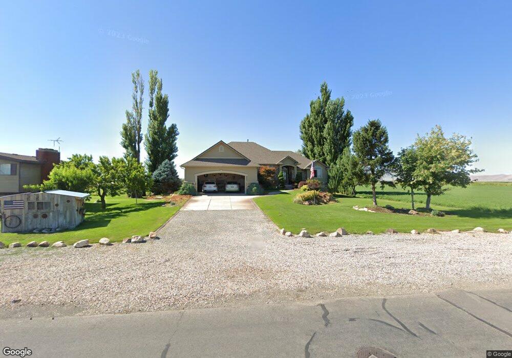
3919 W 2700 S Syracuse, UT 84075
Estimated Value: $605,000 - $957,018
5
Beds
3
Baths
2,148
Sq Ft
$347/Sq Ft
Est. Value
About This Home
This home is located at 3919 W 2700 S, Syracuse, UT 84075 and is currently estimated at $746,005, approximately $347 per square foot. 3919 W 2700 S is a home located in Davis County with nearby schools including Buffalo Point School, Syracuse Junior High School, and Syracuse High School.
Ownership History
Date
Name
Owned For
Owner Type
Purchase Details
Closed on
Jul 16, 2020
Sold by
North Davis Sewer District
Bought by
Syracuse City
Current Estimated Value
Purchase Details
Closed on
Jun 28, 2005
Sold by
Shepherd Scott R and Shepherd Cindy L
Bought by
Shepherd Cindy L and Shepherd Scott R
Purchase Details
Closed on
Feb 8, 2002
Sold by
Shepherd Scott R and Shepherd Cindy L
Bought by
Shepherd Scott R and Shepherd Cindy
Home Financials for this Owner
Home Financials are based on the most recent Mortgage that was taken out on this home.
Original Mortgage
$155,000
Interest Rate
6.61%
Create a Home Valuation Report for This Property
The Home Valuation Report is an in-depth analysis detailing your home's value as well as a comparison with similar homes in the area
Home Values in the Area
Average Home Value in this Area
Purchase History
| Date | Buyer | Sale Price | Title Company |
|---|---|---|---|
| Syracuse City | -- | Cottonwood Title In | |
| Shepherd Cindy L | -- | -- | |
| Shepherd Scott R | -- | Bonneville Title Company Inc |
Source: Public Records
Mortgage History
| Date | Status | Borrower | Loan Amount |
|---|---|---|---|
| Previous Owner | Shepherd Scott R | $155,000 |
Source: Public Records
Tax History Compared to Growth
Tax History
| Year | Tax Paid | Tax Assessment Tax Assessment Total Assessment is a certain percentage of the fair market value that is determined by local assessors to be the total taxable value of land and additions on the property. | Land | Improvement |
|---|---|---|---|---|
| 2025 | $5,559 | $617,633 | $340,987 | $276,646 |
| 2024 | $5,280 | $592,831 | $337,603 | $255,228 |
| 2023 | $5,371 | $880,000 | $414,303 | $465,697 |
| 2022 | $5,564 | $500,500 | $233,417 | $267,083 |
| 2021 | $4,952 | $675,000 | $312,038 | $362,962 |
| 2020 | $4,830 | $636,000 | $279,709 | $356,291 |
| 2019 | $4,856 | $604,000 | $272,367 | $331,633 |
| 2018 | $4,560 | $561,000 | $261,564 | $299,436 |
| 2016 | $3,783 | $295,767 | $133,686 | $162,081 |
| 2015 | $3,760 | $280,533 | $133,686 | $146,847 |
| 2014 | $3,468 | $264,117 | $118,645 | $145,472 |
| 2013 | -- | $264,979 | $125,062 | $139,917 |
Source: Public Records
Map
Nearby Homes
- 2318 S 3450 W
- 3704 W 2170 S Unit 111
- 3475 W 2200 S
- 3360 W 2280 S
- 3032 W Solace St Unit 102
- 2961 S 2425 W Unit 1123
- 2635 S 2430 W Unit 114
- 2971 S 2425 W Unit 1124
- 2625 S 2430 W Unit 112
- 2686 S 2440 W Unit 101
- 3062 W Solace St
- 2983 W North Shore Dr
- 2735 S Shoreline Dr
- 2726 2495 S Unit 205
- 3006 S 2725 W
- 2982 S 3000 W
- 2912 S 3000 W
- 4580 W 1700 S
- 3882 Turnberry Dr
- 2236 S 2685 W