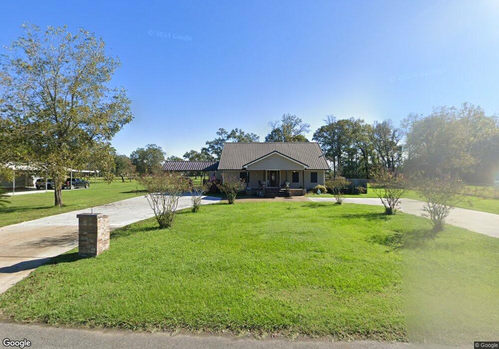
392 Kennison Rd Port Barre, LA 70577
Estimated Value: $55,355 - $140,000
4
Beds
2
Baths
2,192
Sq Ft
$43/Sq Ft
Est. Value
About This Home
This home is located at 392 Kennison Rd, Port Barre, LA 70577 and is currently estimated at $93,785, approximately $42 per square foot. 392 Kennison Rd is a home located in St. Landry Parish with nearby schools including Port Barre Elementary School, Port Barre Middle School, and Port Barre High School.
Ownership History
Date
Name
Owned For
Owner Type
Purchase Details
Closed on
Aug 11, 2014
Bought by
Lalonde Brenda
Current Estimated Value
Purchase Details
Closed on
Sep 28, 2007
Sold by
Deville Randy James and Deville Joycelyn Cottano
Bought by
Lamke Bridgett Nicole
Home Financials for this Owner
Home Financials are based on the most recent Mortgage that was taken out on this home.
Original Mortgage
$25,500
Interest Rate
6.48%
Create a Home Valuation Report for This Property
The Home Valuation Report is an in-depth analysis detailing your home's value as well as a comparison with similar homes in the area
Home Values in the Area
Average Home Value in this Area
Purchase History
| Date | Buyer | Sale Price | Title Company |
|---|---|---|---|
| Lalonde Brenda | -- | -- | |
| Lamke Bridgett Nicole | $30,000 | -- |
Source: Public Records
Mortgage History
| Date | Status | Borrower | Loan Amount |
|---|---|---|---|
| Previous Owner | Lamke Bridgett Nicole | $25,500 |
Source: Public Records
Tax History Compared to Growth
Tax History
| Year | Tax Paid | Tax Assessment Tax Assessment Total Assessment is a certain percentage of the fair market value that is determined by local assessors to be the total taxable value of land and additions on the property. | Land | Improvement |
|---|---|---|---|---|
| 2024 | $394 | $5,660 | $1,390 | $4,270 |
| 2023 | $378 | $5,420 | $1,390 | $4,030 |
| 2022 | $378 | $5,420 | $1,390 | $4,030 |
| 2021 | $378 | $5,420 | $1,390 | $4,030 |
| 2020 | $378 | $5,420 | $1,390 | $4,030 |
| 2019 | $367 | $5,270 | $1,310 | $3,960 |
| 2018 | $367 | $5,270 | $1,310 | $3,960 |
| 2017 | $367 | $5,270 | $1,310 | $3,960 |
| 2015 | $420 | $4,820 | $1,220 | $3,600 |
| 2013 | $418 | $4,820 | $1,220 | $3,600 |
Source: Public Records
Map
Nearby Homes
- 185 Railroad Ave
- 333 Seneca St
- 226 Seneca St
- 217 Pawnee St
- 105 Seneca St
- 125 Fern St
- 440 Saizan Ave
- 328 Saizan Ave
- 3440 Bayou Gerimond Rd
- 107 Frankie Wyble Ave
- 196 Bellanise Rd
- 0 Par Road 3-90 Unit LotWP001
- 138 Oakside Ln
- 151 Hickory St
- Tbd 3 Mile Ave
- 2420 Old 190 Rd
- Tbd Rebel Crossing
- Lot 30 Yankee Camp Rd
- Lot 42 Yankee Camp Rd
- 634 Louisiana 743
- 408 Kennison Rd
- 364 Kennison Rd
- 395 Kennison Rd
- 353 Kennison Rd
- 1647 Bayou Rd
- 324 Kennison Rd
- 1678 Bayou Rd
- 329 Kennison Rd
- 319 Kennison Rd
- 304 Kennison Rd
- 1501 E Courtableau Rd
- 275 Aymond Rd
- 288 Kennison Rd
- 1519 Courtableau Rd
- 295 Kennison Rd
- 1735 Bayou Rd
- 1437 E Courtableau Rd
- 1413 E Courtableau Rd
- 270 Kennison Rd
- 273 Kennison Rd