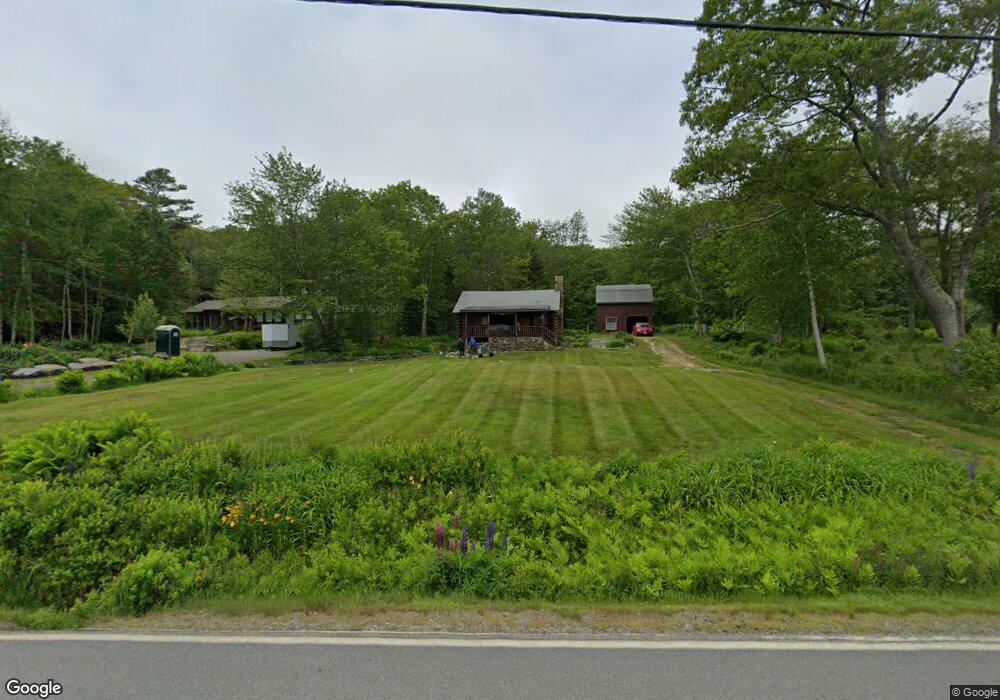
392 State Route 32 Chamberlain, ME 04541
Estimated Value: $719,677 - $920,000
--
Bed
--
Bath
--
Sq Ft
1.25
Acres
About This Home
This home is located at 392 State Route 32, Chamberlain, ME 04541 and is currently estimated at $829,169. 392 State Route 32 is a home with nearby schools including Bristol Consolidated School.
Ownership History
Date
Name
Owned For
Owner Type
Purchase Details
Closed on
Feb 24, 2024
Sold by
Howard Daniel D and Howard Karen A
Bought by
Daniel D & K A Howard Ret and Howard
Current Estimated Value
Purchase Details
Closed on
May 18, 2018
Sold by
Howard John F and Howard Robert K
Bought by
Howard Welsie S
Purchase Details
Closed on
May 14, 2018
Sold by
Welsie S Howard Ret and Howard
Bought by
Howard Welsie S
Purchase Details
Closed on
Oct 16, 2007
Sold by
Howard John F
Bought by
John F Howard Ret and Howard
Create a Home Valuation Report for This Property
The Home Valuation Report is an in-depth analysis detailing your home's value as well as a comparison with similar homes in the area
Home Values in the Area
Average Home Value in this Area
Purchase History
| Date | Buyer | Sale Price | Title Company |
|---|---|---|---|
| Daniel D & K A Howard Ret | -- | None Available | |
| Howard Welsie S | -- | -- | |
| Howard Welsie S | -- | -- | |
| Howard John F | -- | -- | |
| John F Howard Ret | -- | -- |
Source: Public Records
Tax History Compared to Growth
Tax History
| Year | Tax Paid | Tax Assessment Tax Assessment Total Assessment is a certain percentage of the fair market value that is determined by local assessors to be the total taxable value of land and additions on the property. | Land | Improvement |
|---|---|---|---|---|
| 2024 | $4,065 | $456,700 | $302,500 | $154,200 |
| 2023 | $3,631 | $456,700 | $302,500 | $154,200 |
| 2022 | $3,288 | $456,700 | $302,500 | $154,200 |
| 2021 | $3,288 | $456,700 | $302,500 | $154,200 |
| 2020 | $3,311 | $456,700 | $302,500 | $154,200 |
| 2019 | $3,083 | $456,700 | $302,500 | $154,200 |
| 2018 | $2,854 | $456,700 | $302,500 | $154,200 |
| 2017 | $2,854 | $456,700 | $302,500 | $154,200 |
| 2016 | $3,067 | $388,200 | $267,400 | $120,800 |
| 2015 | $3,275 | $387,600 | $267,400 | $120,200 |
| 2014 | $3,062 | $387,600 | $267,400 | $120,200 |
| 2013 | $2,985 | $387,600 | $267,400 | $120,200 |
Source: Public Records
Map
Nearby Homes
- 25 & 26 Maine 32
- 36 Eastwood Ct
- 40 Eastwood Ct
- 146 State Route 32
- 147 Maine 32
- 82 Southside Rd
- 67 Huddle Rd
- 5 Penniman Rd
- 2593 Bristol Rd
- 69 McFarland Shore Rd
- M2A-L45B3 Huddle Rd
- 145 Huddle Rd
- M2-L55F Bristol Rd
- 2700 Bristol Rd
- Lot 5 Jack's Ln
- Lot 4 Jack's Ln
- 0 Lockhart Cove Rd
- 00 Fir Hollow Rd
- 1 Fish Point Rd
- M6l54
- 384 State Route 32
- 397 State Route 32
- 27 Files Way
- 376 State Route 32
- 0 Files Way Unit 989434
- 14 Files Way
- 10 Fogler Rd
- 34 Long Cove Point Rd
- 38 Long Cove Point Rd
- 28 Long Cove Point Rd
- 30 Long Cove Point Rd
- 360 State Route 32
- 419 Maine 32
- 419 State Route 32
- 11 Long Cove Point Rd
- 4 Fogler Rd
- 358 State Route 32
- 57 Files Way
- 356 State Route 32
- 0 Long Cove Point Rd