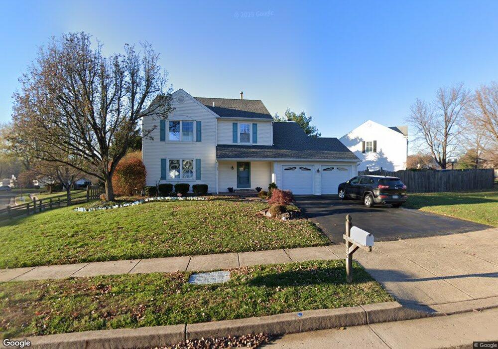
392 Wexley Dr Newtown, PA 18940
Estimated Value: $675,000 - $733,000
4
Beds
3
Baths
1,918
Sq Ft
$368/Sq Ft
Est. Value
About This Home
This home is located at 392 Wexley Dr, Newtown, PA 18940 and is currently estimated at $705,896, approximately $368 per square foot. 392 Wexley Dr is a home located in Bucks County with nearby schools including Goodnoe Elementary School, Newtown Middle School, and Council Rock High School North.
Ownership History
Date
Name
Owned For
Owner Type
Purchase Details
Closed on
May 15, 1995
Sold by
Kerins Maurice J and Kerins Robyn M
Bought by
Lynch Derek A and Granados Mary E
Current Estimated Value
Home Financials for this Owner
Home Financials are based on the most recent Mortgage that was taken out on this home.
Original Mortgage
$180,000
Interest Rate
8.34%
Purchase Details
Closed on
Nov 10, 1986
Bought by
Kerins Maurice J and Kerins Robyn M
Create a Home Valuation Report for This Property
The Home Valuation Report is an in-depth analysis detailing your home's value as well as a comparison with similar homes in the area
Home Values in the Area
Average Home Value in this Area
Purchase History
| Date | Buyer | Sale Price | Title Company |
|---|---|---|---|
| Lynch Derek A | $200,000 | Lawyers Title Insurance Corp | |
| Kerins Maurice J | $131,200 | -- |
Source: Public Records
Mortgage History
| Date | Status | Borrower | Loan Amount |
|---|---|---|---|
| Closed | Lynch Derek A | $180,000 |
Source: Public Records
Tax History Compared to Growth
Tax History
| Year | Tax Paid | Tax Assessment Tax Assessment Total Assessment is a certain percentage of the fair market value that is determined by local assessors to be the total taxable value of land and additions on the property. | Land | Improvement |
|---|---|---|---|---|
| 2025 | $6,590 | $37,080 | $7,160 | $29,920 |
| 2024 | $6,590 | $37,080 | $7,160 | $29,920 |
| 2023 | $6,305 | $37,080 | $7,160 | $29,920 |
| 2022 | $6,183 | $37,080 | $7,160 | $29,920 |
| 2021 | $6,087 | $37,080 | $7,160 | $29,920 |
| 2020 | $5,794 | $37,080 | $7,160 | $29,920 |
| 2019 | $5,657 | $37,080 | $7,160 | $29,920 |
| 2018 | $5,549 | $37,080 | $7,160 | $29,920 |
| 2017 | $5,357 | $37,080 | $7,160 | $29,920 |
| 2016 | $5,320 | $37,080 | $7,160 | $29,920 |
| 2015 | -- | $37,080 | $7,160 | $29,920 |
| 2014 | -- | $37,080 | $7,160 | $29,920 |
Source: Public Records
Map
Nearby Homes
- 215 Rumford Ct
- 101 N Norwood Ave
- 143 N State St
- 313 Washington Ave
- 106 Hicks Alley
- 206 Paxon Alley Unit 51
- 9 Pickering Dr
- 35 Essex Place
- 2 Farmington Place
- 52 Yorkshire Dr
- 8 Bennington Place
- 532 Penn St
- 113 Penn St
- 22 Penn St
- 113 Thorton Ln
- 226 Court St
- 44 Aster Way
- 58 German Ave
- 25 Wellington Rd
- 337 S Lincoln Ave
- 388 Wexley Dr
- 396 Merion Place
- 399 Merion Place
- 386 Merion Place
- 397 Wexley Dr
- 393 Wexley Dr
- 382 Wexley Dr
- 391 Merion Place
- 387 Wexley Dr
- 383 Merion Place
- 376 Wexley Dr
- 381 Wexley Dr
- 370 Merion Place
- 307 Wexley Dr
- 313 Wexley Dr
- 375 Merion Place
- 370 Wexley Dr
- 375 Wexley Dr
- 319 Wexley Dr
- 301 Wexley Dr