


3921 White Sands Dr Bakersfield, CA 93313
Stonegate NeighborhoodEstimated payment $2,578/month
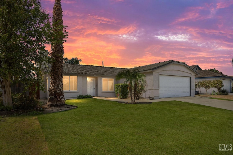
About This Home
Turnkey perfection in Southwest Bakersfield! This beautifully updated 4 bed, 2 bath home shines with owners pride of ownership, fresh interior paint, and a newly painted fence. This home features a bright, open layout, with a desirable floor plan. Stay cool year-round with the recently installed AC system and assume it's 10-year warranty. This clean, bright and open home is truly move-in ready. Great location near parks, schools, and shopping - don't miss this one!
Home Details
Home Type
- Single Family
Year Built
- Built in 2001
Parking
- 2 Car Garage
Interior Spaces
- 1,798 Sq Ft Home
- 1-Story Property
Bedrooms and Bathrooms
- 4 Bedrooms
- 2 Bathrooms
Schools
- Berkshire Elementary School
- Stonecreek Middle School
- Ridgeview High School
Additional Features
- 6,534 Sq Ft Lot
- Central Heating and Cooling System
Community Details
- 5529 Ph 04 Subdivision
Listing and Financial Details
- Assessor Parcel Number 51543306
Map
Home Values in the Area
Average Home Value in this Area
Tax History
We collect this data history from publicly available records. To have your information removed, we recommend requesting removal directly through your county’s website.
| Year | Tax Paid | Tax Assessment Tax Assessment Total Assessment is a certain percentage of the fair market value that is determined by local assessors to be the total taxable value of land and additions on the property. | Land | Improvement |
|---|---|---|---|---|
| 2025 | $3,096 | $197,935 | $44,305 | $153,630 |
| 2024 | $3,043 | $194,055 | $43,437 | $150,618 |
| 2023 | $3,043 | $190,251 | $42,586 | $147,665 |
| 2022 | $2,922 | $186,521 | $41,751 | $144,770 |
| 2021 | $2,806 | $182,865 | $40,933 | $141,932 |
| 2020 | $2,757 | $180,991 | $40,514 | $140,477 |
| 2019 | $2,718 | $180,991 | $40,514 | $140,477 |
| 2018 | $2,610 | $173,965 | $38,942 | $135,023 |
| 2017 | $2,564 | $170,555 | $38,179 | $132,376 |
| 2016 | $2,425 | $167,212 | $37,431 | $129,781 |
| 2015 | $2,408 | $164,701 | $36,869 | $127,832 |
| 2014 | $2,350 | $161,475 | $36,147 | $125,328 |
Property History
We collect this data history from publicly available records. To have your information removed, we recommend requesting removal directly through your county’s website.
| Date | Event | Price | List to Sale | Price per Sq Ft |
|---|---|---|---|---|
| 04/23/2026 04/23/26 | For Rent | $2,550 | 0.0% | -- |
| 11/10/2025 11/10/25 | Price Changed | $429,999 | -4.2% | $239 / Sq Ft |
| 10/15/2025 10/15/25 | For Sale | $449,000 | -- | $250 / Sq Ft |
Purchase History
We collect this data history from publicly available records. To have your information removed, we recommend requesting removal directly through your county’s website.
| Date | Type | Sale Price | Title Company |
|---|---|---|---|
| Interfamily Deed Transfer | -- | None Available | |
| Quit Claim Deed | -- | None Available | |
| Grant Deed | $124,500 | Fidelity National Title Co | |
| Grant Deed | $90,000 | Stewart Title |
Mortgage History
We collect this data history from publicly available records. To have your information removed, we recommend requesting removal directly through your county’s website.
| Date | Status | Loan Amount | Loan Type |
|---|---|---|---|
| Previous Owner | $100,000 | No Value Available | |
| Previous Owner | $90,000 | Construction |
Source: Bakersfield Association of REALTORS® / GEMLS
MLS Number: 202511691
APN: 515-433-06-00-7
Disclaimer: Certain information contained herein is derived from information provided by parties other than Homes.com. All information provided is deemed reliable, but is not guaranteed to be accurate and should be independently verified.
![]() Information is deemed reliable but not guaranteed.
Information is deemed reliable but not guaranteed.
Copyright Golden Empire MLS, Inc. 2026.
- 4206 Berkshire Rd
- 7319 Chilibre St
- 4110 Serene Oak Dr Unit 4
- 4200 Mattnick Dr
- 6510 Summer Breeze Ln
- 4403 Noella Rd
- 4202 Silver Maple Ct Unit 3
- 4315 Serene Oak Dr
- 4102 Sierra Redwood Dr Unit 2
- 4517 Kaytlain Ave
- 6351 Akers Rd Unit 74
- 6351 Akers Rd Unit 91
- 6351 Akers Rd Unit 107
- 6351 Akers Rd
- 6351 Akers Rd Unit 103
- 4012 Maris Ct
- 0 Ringsdale Ct
- 4121 Rio Viejo Dr
- 7418 Wible Rd
- 3158 Berkshire Rd
- 4012 Island Mist Ct
- 4212 Cyclone Dr
- 4204 Serene Oaks Dr
- 2922 Paradise Point Place
- 6208 Stine Rd Unit B
- 4601 Anne Marie St
- 5201 Gasol Ct
- 4809 Millbrook Way
- 8501 Tamworth St
- 5115 Snowdrift Ct
- 2819 Flint Hills Dr Unit 4
- 3003 Monache Meadows Dr
- 2016 Ocean View Dr
- 5901 Blue Spruce Ave
- 8211 Slider Dr
- 5421 Tejon Ridge Ct
- 6513 Pine View Dr
- 1718 Panama Ln
- 5818 Clear Valley Ct
- 5704 Pine Canyon Dr

Ask me questions while you tour the home.