Estimated Value: $344,087 - $450,000
3
Beds
2
Baths
1,490
Sq Ft
$265/Sq Ft
Est. Value
About This Home
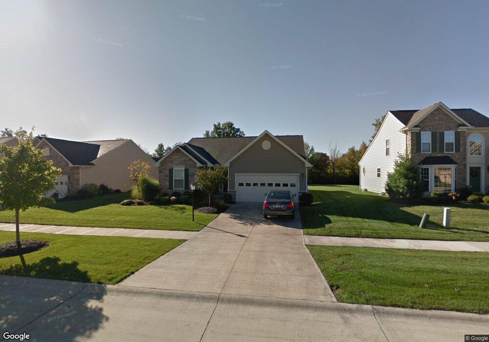
This home is located at 39211 Hawthorne Dr, Avon, OH 44011 and is currently estimated at $394,272, approximately $264 per square foot. 39211 Hawthorne Dr is a home located in Lorain County with nearby schools including Avon Heritage South Elementary School, Avon East Elementary School, and Avon Middle School.
Ownership History
Date
Name
Owned For
Owner Type
Purchase Details
Closed on
Sep 16, 2011
Sold by
Rulton Richard A and Estate Of Ann Lizabeth Rulton
Bought by
Woodward Sara and Woodward Charles Alden
Current Estimated Value
Purchase Details
Closed on
Nov 15, 2007
Sold by
Nvr Inc
Bought by
Rulton Ann Lizabeth
Home Financials for this Owner
Home Financials are based on the most recent Mortgage that was taken out on this home.
Original Mortgage
$135,000
Interest Rate
6.3%
Mortgage Type
Purchase Money Mortgage
Purchase Details
Closed on
Sep 26, 2007
Sold by
Orchard Trail Llc
Bought by
Nvr Inc and Ryan Homes
Home Financials for this Owner
Home Financials are based on the most recent Mortgage that was taken out on this home.
Original Mortgage
$135,000
Interest Rate
6.3%
Mortgage Type
Purchase Money Mortgage
Create a Home Valuation Report for This Property
The Home Valuation Report is an in-depth analysis detailing your home's value as well as a comparison with similar homes in the area
Home Values in the Area
Average Home Value in this Area
Purchase History
| Date | Buyer | Sale Price | Title Company |
|---|---|---|---|
| Woodward Sara | $180,000 | Maximum Title No | |
| Rulton Ann Lizabeth | $219,300 | -- | |
| Nvr Inc | $55,800 | None Available |
Source: Public Records
Mortgage History
| Date | Status | Borrower | Loan Amount |
|---|---|---|---|
| Previous Owner | Rulton Ann Lizabeth | $135,000 |
Source: Public Records
Tax History
| Year | Tax Paid | Tax Assessment Tax Assessment Total Assessment is a certain percentage of the fair market value that is determined by local assessors to be the total taxable value of land and additions on the property. | Land | Improvement |
|---|---|---|---|---|
| 2024 | $4,779 | $107,016 | $33,250 | $73,766 |
| 2023 | $4,374 | $88,235 | $25,778 | $62,458 |
| 2022 | $4,356 | $88,235 | $25,778 | $62,458 |
| 2021 | $4,365 | $88,235 | $25,778 | $62,458 |
| 2020 | $4,045 | $77,880 | $22,750 | $55,130 |
| 2019 | $3,962 | $77,880 | $22,750 | $55,130 |
| 2018 | $3,671 | $77,880 | $22,750 | $55,130 |
| 2017 | $3,571 | $71,400 | $21,160 | $50,240 |
| 2016 | $3,613 | $71,400 | $21,160 | $50,240 |
| 2015 | $3,648 | $71,400 | $21,160 | $50,240 |
| 2014 | $3,485 | $69,100 | $20,480 | $48,620 |
| 2013 | $3,473 | $68,560 | $20,480 | $48,080 |
Source: Public Records
Map
Nearby Homes
- 3157 Orr's Orchard
- 5419 Deerpath Dr
- 38880 Amberwood Dr
- 38841 Detroit Rd
- 38488 Briar Lakes Dr
- 3147 Fairview Dr
- 0 Springfield Dr
- 2430 Woodhawk Ln
- 5326 Reserve Way
- 38690 Thorton Ln
- 3350 Long Rd
- 3006 Abbe Rd N
- 38806 Coronado Ave
- 5514 Detroit Rd
- 5302 Charlotte's Way Unit 33
- 5297 College Heights Blvd
- 38778 Renwood Ave Unit 12
- 38446 Foxglen Ave
- 5298 Garfield Blvd
- 2565 Abbe Rd
- 39205 Hawthorne Dr
- 39217 Hawthorne Dr
- 39195 Hawthorne Dr
- 39223 Hawthorne Dr
- 39212 Hawthorne Dr
- 39206 Hawthorne Dr
- 39193 Hawthorne Dr
- 39218 Hawthorne Dr
- 39234 Winesap Trail
- 39215 Winesap Trail
- 39196 Hawthorne Dr
- 39240 Winesap Trail
- 39224 Hawthorne Dr
- 39229 Hawthorne Dr
- 39191 Hawthorne Dr
- 39246 Winesap Trail
- 3130 Grove Ln
- 39235 Hawthorne Dr
- 3135 Grove Ln
- 39189 Hawthorne Dr
Your Personal Tour Guide
Ask me questions while you tour the home.