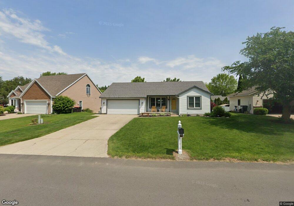
3923 Brookfield Dr Hudsonville, MI 49426
Estimated Value: $348,635 - $394,000
3
Beds
2
Baths
1,188
Sq Ft
$315/Sq Ft
Est. Value
About This Home
This home is located at 3923 Brookfield Dr, Hudsonville, MI 49426 and is currently estimated at $373,659, approximately $314 per square foot. 3923 Brookfield Dr is a home located in Ottawa County with nearby schools including Baldwin Street Middle School, Hudsonville Freshman Campus, and Hudsonville High School.
Ownership History
Date
Name
Owned For
Owner Type
Purchase Details
Closed on
Jul 22, 2005
Sold by
Vantubergen Mark and Vantubergen Van Tubergen
Bought by
Hayes Dean A and Hayes Sandra
Current Estimated Value
Home Financials for this Owner
Home Financials are based on the most recent Mortgage that was taken out on this home.
Original Mortgage
$129,300
Outstanding Balance
$67,714
Interest Rate
5.71%
Mortgage Type
Fannie Mae Freddie Mac
Estimated Equity
$305,945
Create a Home Valuation Report for This Property
The Home Valuation Report is an in-depth analysis detailing your home's value as well as a comparison with similar homes in the area
Home Values in the Area
Average Home Value in this Area
Purchase History
| Date | Buyer | Sale Price | Title Company |
|---|---|---|---|
| Hayes Dean A | $162,300 | Lighthouse Title Inc |
Source: Public Records
Mortgage History
| Date | Status | Borrower | Loan Amount |
|---|---|---|---|
| Open | Hayes Dean A | $129,300 |
Source: Public Records
Tax History Compared to Growth
Tax History
| Year | Tax Paid | Tax Assessment Tax Assessment Total Assessment is a certain percentage of the fair market value that is determined by local assessors to be the total taxable value of land and additions on the property. | Land | Improvement |
|---|---|---|---|---|
| 2025 | $2,348 | $154,200 | $0 | $0 |
| 2024 | $2,032 | $149,400 | $0 | $0 |
| 2023 | $1,940 | $131,800 | $0 | $0 |
| 2022 | $2,132 | $116,300 | $0 | $0 |
| 2021 | $2,072 | $106,700 | $0 | $0 |
| 2020 | $2,050 | $101,600 | $0 | $0 |
| 2019 | $2,053 | $93,400 | $0 | $0 |
| 2018 | $1,914 | $86,500 | $0 | $0 |
| 2017 | $1,879 | $83,900 | $0 | $0 |
| 2016 | $1,868 | $79,300 | $0 | $0 |
| 2015 | $1,783 | $74,900 | $0 | $0 |
| 2014 | $1,783 | $69,800 | $0 | $0 |
Source: Public Records
Map
Nearby Homes
- 3808 Port Sheldon St
- 3755 Black Creek Dr
- 4106 Blair St
- 4372 Shady Oak Ct
- 6950 Meadowcreek Dr
- 5744 36th Ave
- V/L Port Sheldon St
- 7068 Jasper Dr
- 3204 Port Sheldon St
- 5640 Lawndale Ave
- 6863 Bridgeport Dr
- 3550 Oak St
- 5570 Marlin Ave
- 7114 Tory Dr
- 6207 Gemini Ct
- 6620 Sheldon Crossings Dr
- 3505 Curtis St
- 3979 Grant St
- 2969 Osprey Dr Unit 27
- 3528 Tearose Dr
- 3913 Brookfield Dr
- 3929 Brookfield Dr
- 3924 Pebblefield Dr
- 3912 Pebblefield Dr
- 3938 Pebblefield Dr
- 3901 Brookfield Dr
- 3922 Brookfield Dr
- 3900 Pebblefield Dr
- 3934 Brookfield Dr
- 3889 Brookfield Dr
- 3946 Brookfield Dr
- 3890 Pebblefield Dr
- 3900 Brookfield Dr
- 3958 Brookfield Dr
- 3959 Pebblefield Dr
- 3879 Brookfield Dr
- 3923 Pebblefield Dr
- 3935 Pebblefield Dr
- 3884 Brookfield Dr
- 3911 Pebblefield Dr