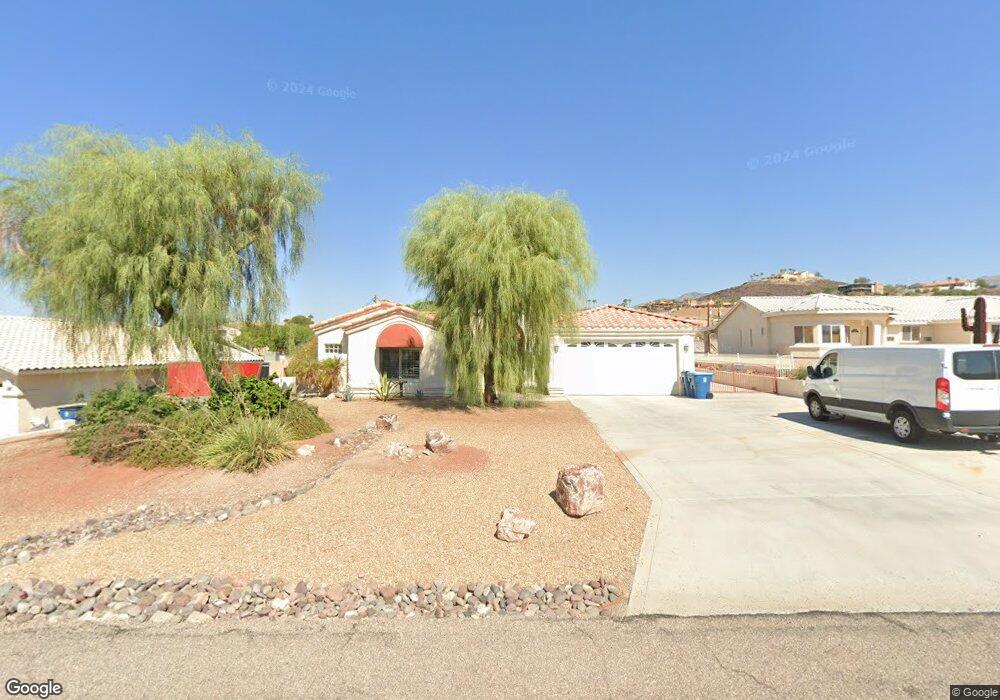
3923 Sloop Dr Lake Havasu City, AZ 86406
Estimated Value: $655,000 - $943,000
4
Beds
2
Baths
2,162
Sq Ft
$354/Sq Ft
Est. Value
About This Home
This home is located at 3923 Sloop Dr, Lake Havasu City, AZ 86406 and is currently estimated at $765,590, approximately $354 per square foot. 3923 Sloop Dr is a home located in Mohave County with nearby schools including Jamaica Elementary School, Thunderbolt Middle School, and Lake Havasu High School.
Ownership History
Date
Name
Owned For
Owner Type
Purchase Details
Closed on
Oct 3, 2014
Sold by
Clark Dale Patrick and Clark Regina Diane
Bought by
Clark Dale Patrick and Clark Regina Diane
Current Estimated Value
Home Financials for this Owner
Home Financials are based on the most recent Mortgage that was taken out on this home.
Original Mortgage
$65,000
Interest Rate
4.08%
Mortgage Type
New Conventional
Purchase Details
Closed on
Apr 4, 2007
Sold by
Sterley Regina I
Bought by
Clark Dale Patrick and Clark Regina Diane
Purchase Details
Closed on
Aug 7, 2006
Sold by
Bess William E and Bess Marilyn D
Bought by
Patrick Dale and Clark Regina Diane
Purchase Details
Closed on
Jan 11, 2001
Sold by
Mullen Sharlene Gallup and Gallup Sharlene L
Bought by
Bess William E and Bess Marilyn D
Create a Home Valuation Report for This Property
The Home Valuation Report is an in-depth analysis detailing your home's value as well as a comparison with similar homes in the area
Home Values in the Area
Average Home Value in this Area
Purchase History
| Date | Buyer | Sale Price | Title Company |
|---|---|---|---|
| Clark Dale Patrick | -- | None Available | |
| Clark Dale Patrick | -- | None Available | |
| Patrick Dale | $532,500 | First American Title Ins Co | |
| Bess William E | $36,000 | Transnation Title Insurance |
Source: Public Records
Mortgage History
| Date | Status | Borrower | Loan Amount |
|---|---|---|---|
| Closed | Clark Dale Patrick | $65,000 |
Source: Public Records
Tax History Compared to Growth
Tax History
| Year | Tax Paid | Tax Assessment Tax Assessment Total Assessment is a certain percentage of the fair market value that is determined by local assessors to be the total taxable value of land and additions on the property. | Land | Improvement |
|---|---|---|---|---|
| 2026 | -- | -- | -- | -- |
| 2025 | $2,708 | $62,176 | $0 | $0 |
| 2024 | $2,708 | $60,847 | $0 | $0 |
| 2023 | $2,708 | $56,821 | $0 | $0 |
| 2022 | $2,581 | $47,167 | $0 | $0 |
| 2021 | $2,829 | $44,498 | $0 | $0 |
| 2019 | $2,684 | $39,315 | $0 | $0 |
| 2018 | $2,591 | $37,572 | $0 | $0 |
| 2017 | $2,545 | $35,638 | $0 | $0 |
| 2016 | $2,244 | $31,564 | $0 | $0 |
| 2015 | $2,183 | $27,815 | $0 | $0 |
Source: Public Records
Map
Nearby Homes
- 3883 Sloop Dr
- 3873 Packard Place
- 4019 Black Hill Dr
- 3956 Cherry Tree Blvd
- 4051 Northstar Dr
- 3828 Cherry Tree Blvd
- 3856 Mission Dr N
- 3937 Comet Dr
- 3812 Yonder Dr
- 4014 Cherry Tree Blvd
- 3852 Solar Dr
- 4050 Cherry Tree Blvd
- 4019 Bluegrass Dr
- 4094 Cherry Tree Place
- 4021 Tierra Vista Dr
- 361 Mcculloch Blvd S
- 3751 Mission Dr S
- 386 Mcculloch Blvd S
- 3808 Whaler Dr
- 3830 Bluegrass Dr