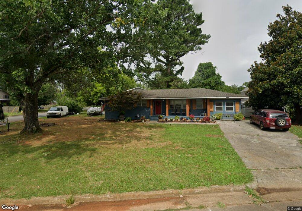
3925 Telstar Cir SW Huntsville, AL 35805
West Huntsville NeighborhoodEstimated Value: $158,000 - $169,899
--
Bed
1
Bath
1,278
Sq Ft
$130/Sq Ft
Est. Value
About This Home
This home is located at 3925 Telstar Cir SW, Huntsville, AL 35805 and is currently estimated at $165,725, approximately $129 per square foot. 3925 Telstar Cir SW is a home with nearby schools including McDonnell Elementary School, Whitesburg Elementary School, and Virgil Grissom High School.
Ownership History
Date
Name
Owned For
Owner Type
Purchase Details
Closed on
Aug 24, 2025
Sold by
Mcanally Jody L
Bought by
Mcanally Jody L and Mcanally Carrie E
Current Estimated Value
Purchase Details
Closed on
Jul 31, 2007
Sold by
Hopkins Miriam S
Bought by
Mcanally Jody L
Home Financials for this Owner
Home Financials are based on the most recent Mortgage that was taken out on this home.
Original Mortgage
$62,600
Interest Rate
6.65%
Mortgage Type
Seller Take Back
Create a Home Valuation Report for This Property
The Home Valuation Report is an in-depth analysis detailing your home's value as well as a comparison with similar homes in the area
Home Values in the Area
Average Home Value in this Area
Purchase History
| Date | Buyer | Sale Price | Title Company |
|---|---|---|---|
| Mcanally Jody L | -- | None Listed On Document | |
| Mcanally Jody L | -- | -- |
Source: Public Records
Mortgage History
| Date | Status | Borrower | Loan Amount |
|---|---|---|---|
| Previous Owner | Mcanally Jody L | $62,600 |
Source: Public Records
Tax History Compared to Growth
Tax History
| Year | Tax Paid | Tax Assessment Tax Assessment Total Assessment is a certain percentage of the fair market value that is determined by local assessors to be the total taxable value of land and additions on the property. | Land | Improvement |
|---|---|---|---|---|
| 2025 | $770 | $14,100 | $2,280 | $11,820 |
| 2024 | $770 | $13,180 | $2,280 | $10,900 |
| 2023 | $553 | $10,360 | $1,520 | $8,840 |
| 2022 | $487 | $9,220 | $1,520 | $7,700 |
| 2021 | $437 | $8,360 | $1,520 | $6,840 |
| 2020 | $401 | $7,730 | $1,140 | $6,590 |
| 2019 | $401 | $7,730 | $1,140 | $6,590 |
| 2018 | $401 | $7,740 | $0 | $0 |
| 2017 | $401 | $7,740 | $0 | $0 |
| 2016 | $401 | $7,740 | $0 | $0 |
| 2015 | $401 | $7,740 | $0 | $0 |
| 2014 | $402 | $7,760 | $0 | $0 |
Source: Public Records
Map
Nearby Homes
- 3615 Squaw Valley Dr SW
- 4013 Patty Ann Dr SW
- 3706 Squaw Valley Dr SW
- 4403 Gazette Dr SW
- 4027 Telstar Cir SW
- 4410 Gazette Dr SW
- 1.43 Conger Rd SW
- 1.43 Acres Conger Rd SW
- 0 Conger Rd SW
- 3520 Conger Rd SW
- 3509 Conger Rd SW
- 4105 Broyles Ave SW
- 4011 Eunice St SW
- 4104 Mcvay St SW Unit A & B
- 3306 Spinners Ct
- 3310 Spinners Ct
- 3312 Spinners Ct
- 3308 Spinners Ct
- 3408 Conger Rd SW
- 4001 Newson Rd SW
- 3921 Telstar Cir SW
- 4001 Apollo Dr SW
- 4003 Apollo Dr SW
- 3919 Telstar Cir SW
- 3920 Telstar Cir SW
- 3928 Telstar Cir SW
- 3918 Telstar Cir SW
- 4005 Apollo Dr SW
- 3930 Telstar Cir SW
- 3922 Telstar Cir SW
- 3932 Telstar Cir SW
- 3926 Telstar Cir SW
- 3924 Telstar Cir SW
- 3917 Telstar Cir SW
- 3916 Telstar Cir SW
- 4007 Apollo Dr SW
- 3934 Telstar Cir SW
- 3914 Telstar Cir SW
- 4000 Apollo Dr SW
- 4002 Apollo Dr SW