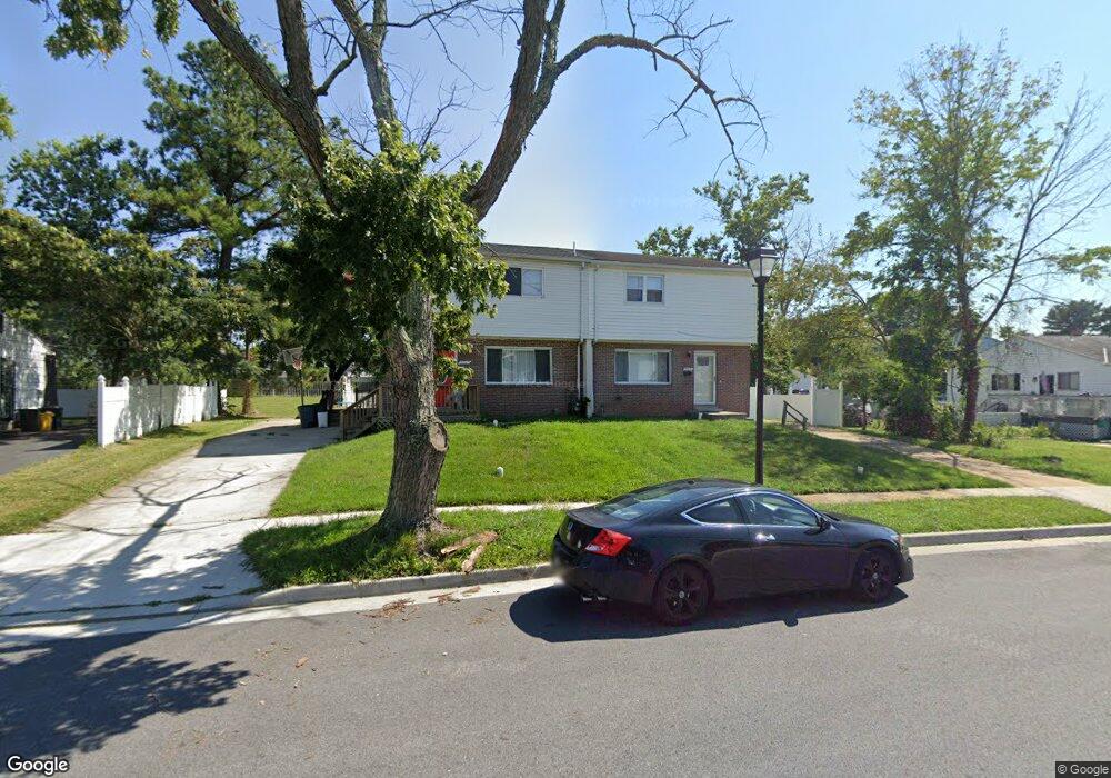
3927 Bryony Rd Randallstown, MD 21133
Estimated Value: $277,767 - $336,000
Studio
2
Baths
1,219
Sq Ft
$256/Sq Ft
Est. Value
About This Home
This home is located at 3927 Bryony Rd, Randallstown, MD 21133 and is currently estimated at $312,442, approximately $256 per square foot. 3927 Bryony Rd is a home located in Baltimore County with nearby schools including Randallstown Elementary School, Deer Park Middle Magnet School, and Randallstown High School.
Ownership History
Date
Name
Owned For
Owner Type
Purchase Details
Closed on
Mar 27, 2017
Sold by
Citimortgage Inc
Bought by
Cr Of Maryland Llc
Current Estimated Value
Purchase Details
Closed on
Dec 6, 2016
Sold by
Jones Terle Tamara
Bought by
Citi Mortgage Inc
Purchase Details
Closed on
May 16, 1995
Sold by
Mindel Gilbert J
Bought by
Jones Terle T
Home Financials for this Owner
Home Financials are based on the most recent Mortgage that was taken out on this home.
Original Mortgage
$88,497
Interest Rate
8.31%
Create a Home Valuation Report for This Property
The Home Valuation Report is an in-depth analysis detailing your home's value as well as a comparison with similar homes in the area
Home Values in the Area
Average Home Value in this Area
Purchase History
| Date | Buyer | Sale Price | Title Company |
|---|---|---|---|
| Cr Of Maryland Llc | $93,055 | Lakeside Tittle Co | |
| Citi Mortgage Inc | $114,380 | None Available | |
| Jones Terle T | $89,000 | -- |
Source: Public Records
Mortgage History
| Date | Status | Borrower | Loan Amount |
|---|---|---|---|
| Previous Owner | Jones Terle T | $88,497 |
Source: Public Records
Tax History
| Year | Tax Paid | Tax Assessment Tax Assessment Total Assessment is a certain percentage of the fair market value that is determined by local assessors to be the total taxable value of land and additions on the property. | Land | Improvement |
|---|---|---|---|---|
| 2025 | $3,033 | $193,267 | -- | -- |
| 2024 | $3,033 | $167,700 | $40,000 | $127,700 |
| 2023 | $2,996 | $156,933 | $0 | $0 |
| 2022 | $3,136 | $146,167 | $0 | $0 |
| 2021 | $1,372 | $135,400 | $40,000 | $95,400 |
| 2020 | $2,625 | $134,133 | $0 | $0 |
| 2019 | $1,610 | $132,867 | $0 | $0 |
| 2018 | $2,040 | $131,600 | $37,400 | $94,200 |
| 2017 | $1,905 | $128,700 | $0 | $0 |
| 2016 | $2,027 | $125,800 | $0 | $0 |
| 2015 | $2,027 | $122,900 | $0 | $0 |
| 2014 | $2,027 | $122,900 | $0 | $0 |
Source: Public Records
Map
Nearby Homes
- 9063 Meadow Heights Rd
- 1205/99 Winands Rd
- 8829 Sigrid Rd
- 4228 Red Ridge Way
- 4048 Carthage Rd
- 4226 Huntshire Rd
- 3723 Eastman Rd
- 9202 Samoset Rd
- 4023 Paige View Rd
- 8604 Woodbrook Ct
- 8605 Lucerne Rd
- 9129 Marlove Oaks Ln
- 8811 Stoneridge Cir Unit 103
- 8809 Stone Ridge Cir Unit 204
- 8807 Stone Ridge Cir Unit 101
- 9104 Marlove Oaks Ln
- 9130 Marlove Oaks Ln
- 8541 Lucerne Rd
- 8905 Stone Creek Place Unit 201
- 4112 Spider Lily Way
- 3925 Bryony Rd
- 3929 Bryony Rd
- 3923 Bryony Rd
- 3931 Bryony Rd
- 3928 Bryony Rd
- 3930 Bryony Rd
- 4 Francine Ct
- 3921 Bryony Rd
- 6 Francine Ct
- 3932 Bryony Rd
- 3926 Bryony Rd
- 3933 Bryony Rd
- 3944 Mcdonogh Rd
- 3946 Mcdonogh Rd
- 3942 Mcdonogh Rd
- 3924 Bryony Rd
- 8 Francine Ct
- 3934 Bryony Rd
- 3948 Mcdonogh Rd
- 3940 Mcdonogh Rd
Your Personal Tour Guide
Ask me questions while you tour the home.