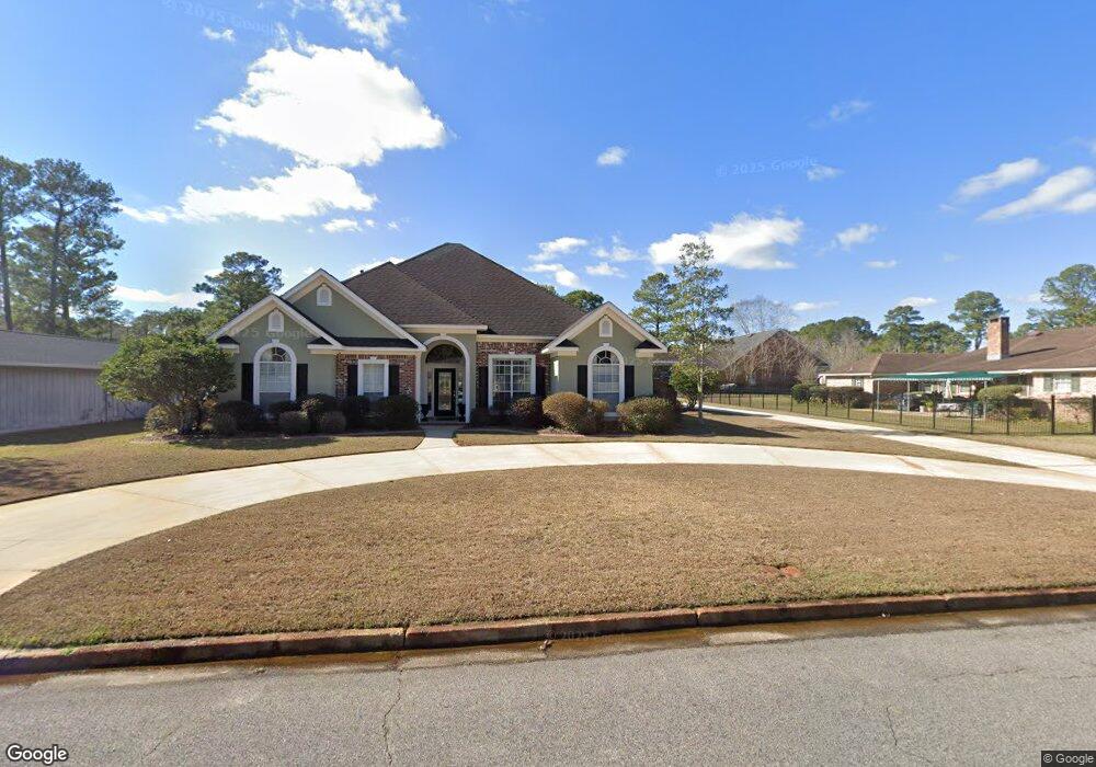
3928 Saint Andrews Loop E Mobile, AL 36693
Riviere Du Chien NeighborhoodEstimated Value: $265,000 - $362,000
4
Beds
3
Baths
2,368
Sq Ft
$135/Sq Ft
Est. Value
About This Home
This home is located at 3928 Saint Andrews Loop E, Mobile, AL 36693 and is currently estimated at $318,562, approximately $134 per square foot. 3928 Saint Andrews Loop E is a home located in Mobile County with nearby schools including Kate Shepard Elementary School, Burns Middle School, and Ben C Rain High School.
Ownership History
Date
Name
Owned For
Owner Type
Purchase Details
Closed on
Oct 15, 2025
Sold by
William Mann Michael and Dobbs Deborah
Bought by
Michael William Mann Revocable Trust and Mann
Current Estimated Value
Purchase Details
Closed on
Jan 11, 2002
Sold by
Twilley Brothers Builders Inc
Bought by
Mann Michael William
Home Financials for this Owner
Home Financials are based on the most recent Mortgage that was taken out on this home.
Original Mortgage
$175,000
Interest Rate
6.85%
Create a Home Valuation Report for This Property
The Home Valuation Report is an in-depth analysis detailing your home's value as well as a comparison with similar homes in the area
Home Values in the Area
Average Home Value in this Area
Purchase History
| Date | Buyer | Sale Price | Title Company |
|---|---|---|---|
| Michael William Mann Revocable Trust | $284,400 | None Listed On Document | |
| Mann Michael William | -- | -- |
Source: Public Records
Mortgage History
| Date | Status | Borrower | Loan Amount |
|---|---|---|---|
| Previous Owner | Mann Michael William | $175,000 | |
| Closed | Mann Michael William | $175,000 |
Source: Public Records
Tax History
| Year | Tax Paid | Tax Assessment Tax Assessment Total Assessment is a certain percentage of the fair market value that is determined by local assessors to be the total taxable value of land and additions on the property. | Land | Improvement |
|---|---|---|---|---|
| 2025 | $1,694 | $30,250 | $4,000 | $26,250 |
| 2024 | $1,694 | $28,440 | $4,000 | $24,440 |
| 2023 | $1,591 | $25,660 | $3,990 | $21,670 |
| 2022 | $1,265 | $22,720 | $3,990 | $18,730 |
| 2021 | $1,148 | $20,660 | $3,690 | $16,970 |
| 2020 | $1,172 | $21,260 | $3,690 | $17,570 |
| 2019 | $1,225 | $20,340 | $0 | $0 |
| 2018 | $1,236 | $20,520 | $0 | $0 |
| 2017 | $1,118 | $18,660 | $0 | $0 |
| 2016 | $1,279 | $21,200 | $0 | $0 |
| 2013 | $1,293 | $21,040 | $0 | $0 |
Source: Public Records
Map
Nearby Homes
- 0 St Andrews Dr E Unit 7510683
- 3921 Saint Andrews Dr E
- 3921 St Andrews Dr E
- 3112 Riviere Du Chien Loop W
- 3847 Riviere Du Chien Rd
- 4035 Leighton Place Dr
- 4039 Leighton Place Dr
- 4043 Leighton Place Dr
- 4062 Leighton Place Dr
- 3415 Riviere Du Chien Loop N
- 3914 Blue Gill Cir
- 0 Rosie Rd Unit 7487049
- 0 Rosie Rd Unit 7522718
- 4000 Lloyd Station Rd
- 0 Rosie's Rd Unit 5 373971
- 0 Rosie's Rd Unit 2
- 4525 Brentwood Dr
- 4298 Alden Dr
- 4319 Alden Dr
- 4332 Alden Dr
- 3801 Saint Andrews Dr
- 3932 Saint Andrews Loop E
- 3805 Saint Andrews Dr
- 3933 Saint Andrews Loop E
- 3925 Saint Andrews Loop E
- 3933 St Andrews Loop E
- 3809 Saint Andrews Dr
- 3921 Saint Andrews Loop E
- 3800 St Andrews Dr
- 3800 Saint Andrews Dr
- 3804 Saint Andrews Dr
- 3808 Saint Andrews Dr
- 3813 Saint Andrews Dr
- 3917 Saint Andrews Loop E
- 3917 St Andrews Loop E
- 3812 St Andrews Dr
- 3812 Saint Andrews Dr
- 3817 St Andrews Dr
- 3817 Saint Andrews Dr
- 3908 Saint Andrews Loop E
Your Personal Tour Guide
Ask me questions while you tour the home.