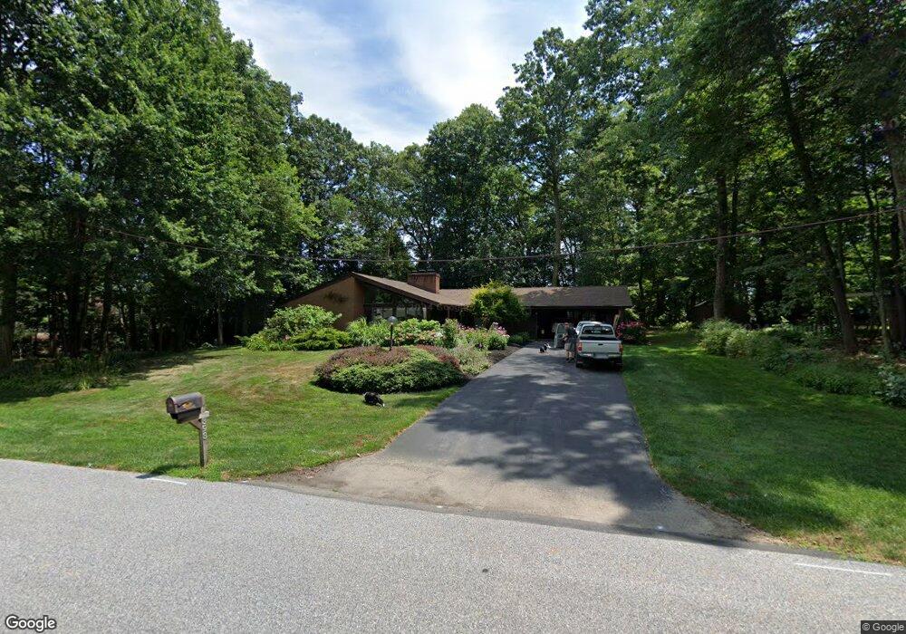
393 Oakwood Rd New Freedom, PA 17349
Estimated Value: $451,000 - $517,000
3
Beds
3
Baths
3,174
Sq Ft
$149/Sq Ft
Est. Value
About This Home
This home is located at 393 Oakwood Rd, New Freedom, PA 17349 and is currently estimated at $474,402, approximately $149 per square foot. 393 Oakwood Rd is a home located in York County with nearby schools including Susquehannock High School, Shrewsbury Christian Academy, and St John The Baptist Catholic School.
Ownership History
Date
Name
Owned For
Owner Type
Purchase Details
Closed on
Oct 9, 2014
Sold by
Sobolev Lennon Jr Robert J and Sobolev Lennon Diana
Bought by
Tirdil Alan J and Tirdil Angela B
Current Estimated Value
Home Financials for this Owner
Home Financials are based on the most recent Mortgage that was taken out on this home.
Original Mortgage
$225,000
Outstanding Balance
$172,432
Interest Rate
4.09%
Mortgage Type
New Conventional
Estimated Equity
$301,970
Purchase Details
Closed on
Jan 29, 1993
Bought by
Lennon Robert J
Create a Home Valuation Report for This Property
The Home Valuation Report is an in-depth analysis detailing your home's value as well as a comparison with similar homes in the area
Home Values in the Area
Average Home Value in this Area
Purchase History
| Date | Buyer | Sale Price | Title Company |
|---|---|---|---|
| Tirdil Alan J | $250,000 | None Available | |
| Lennon Robert J | -- | -- |
Source: Public Records
Mortgage History
| Date | Status | Borrower | Loan Amount |
|---|---|---|---|
| Open | Tirdil Alan J | $225,000 |
Source: Public Records
Tax History Compared to Growth
Tax History
| Year | Tax Paid | Tax Assessment Tax Assessment Total Assessment is a certain percentage of the fair market value that is determined by local assessors to be the total taxable value of land and additions on the property. | Land | Improvement |
|---|---|---|---|---|
| 2025 | $6,101 | $220,460 | $52,460 | $168,000 |
| 2024 | $5,927 | $220,460 | $52,460 | $168,000 |
| 2023 | $5,927 | $220,460 | $52,460 | $168,000 |
| 2022 | $5,927 | $220,460 | $52,460 | $168,000 |
| 2021 | $5,621 | $217,660 | $52,460 | $165,200 |
| 2020 | $5,621 | $217,660 | $52,460 | $165,200 |
| 2019 | $5,573 | $217,660 | $52,460 | $165,200 |
| 2018 | $5,471 | $217,660 | $52,460 | $165,200 |
| 2017 | $5,371 | $217,660 | $52,460 | $165,200 |
| 2016 | $0 | $216,740 | $52,460 | $164,280 |
| 2015 | -- | $216,740 | $52,460 | $164,280 |
| 2014 | -- | $216,740 | $52,460 | $164,280 |
Source: Public Records
Map
Nearby Homes
- 17453 Reddale Dr
- 521 Windy Hill Rd
- 111 Penny Ln
- Lot #1 Norland Way Unit COVINGTON
- 318 Eliza Rd
- 677 Keller Rd
- 411 Peggy Ln
- 452 Hilltop Ct
- 17217 Russett Farm Dr
- 15 Foundry Rd
- 21618 York Rd
- 606 Freeland Rd
- 610 E Tolna Rd Unit SAVANNAH
- 610 E Tolna Rd Unit ADDISON
- 610 E Tolna Rd Unit HAWTHORNE
- 610 E Tolna Rd Unit DEVONSHIRE
- Augusta Plan at Foxhaven
- Devonshire Plan at Foxhaven
- Kipling Plan at Foxhaven
- Addison Plan at Foxhaven