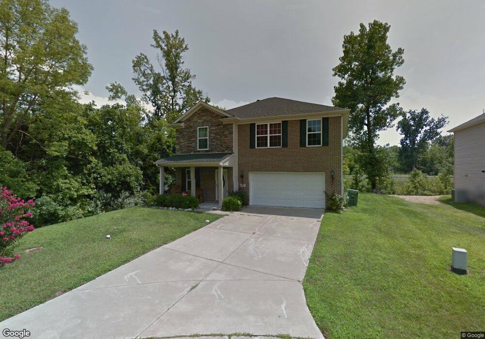
3933 Bronson Ln Evansville, IN 47711
Melody Hill NeighborhoodEstimated Value: $268,000 - $344,000
4
Beds
3
Baths
2,380
Sq Ft
$126/Sq Ft
Est. Value
About This Home
This home is located at 3933 Bronson Ln, Evansville, IN 47711 and is currently estimated at $299,245, approximately $125 per square foot. 3933 Bronson Ln is a home located in Vanderburgh County with nearby schools including Vogel Elementary School, North Junior High School, and North High School.
Ownership History
Date
Name
Owned For
Owner Type
Purchase Details
Closed on
Jul 1, 2020
Sold by
Burns Charles R
Bought by
Burns Charles and Burns Carrie E
Current Estimated Value
Home Financials for this Owner
Home Financials are based on the most recent Mortgage that was taken out on this home.
Original Mortgage
$144,200
Outstanding Balance
$97,924
Interest Rate
3%
Mortgage Type
New Conventional
Estimated Equity
$201,321
Purchase Details
Closed on
Mar 29, 2011
Sold by
Jagoe Homes Inc
Bought by
Burns Charles
Home Financials for this Owner
Home Financials are based on the most recent Mortgage that was taken out on this home.
Original Mortgage
$169,900
Interest Rate
3.5%
Mortgage Type
VA
Create a Home Valuation Report for This Property
The Home Valuation Report is an in-depth analysis detailing your home's value as well as a comparison with similar homes in the area
Home Values in the Area
Average Home Value in this Area
Purchase History
| Date | Buyer | Sale Price | Title Company |
|---|---|---|---|
| Burns Charles | -- | None Available | |
| Burns Charles | -- | None Available |
Source: Public Records
Mortgage History
| Date | Status | Borrower | Loan Amount |
|---|---|---|---|
| Open | Burns Charles | $144,200 | |
| Closed | Burns Charles | $169,900 |
Source: Public Records
Tax History
| Year | Tax Paid | Tax Assessment Tax Assessment Total Assessment is a certain percentage of the fair market value that is determined by local assessors to be the total taxable value of land and additions on the property. | Land | Improvement |
|---|---|---|---|---|
| 2025 | $2,922 | $282,300 | $34,800 | $247,500 |
| 2024 | $2,922 | $276,100 | $26,800 | $249,300 |
| 2023 | $2,863 | $271,400 | $26,800 | $244,600 |
| 2022 | $3,070 | $275,800 | $26,800 | $249,000 |
| 2021 | $2,270 | $204,100 | $26,800 | $177,300 |
| 2020 | $2,218 | $206,400 | $26,800 | $179,600 |
| 2019 | $2,015 | $191,900 | $26,800 | $165,100 |
| 2018 | $1,793 | $183,200 | $26,800 | $156,400 |
| 2017 | $1,647 | $173,100 | $26,800 | $146,300 |
| 2016 | $1,623 | $174,700 | $26,800 | $147,900 |
| 2014 | $1,595 | $173,500 | $26,800 | $146,700 |
| 2013 | -- | $169,100 | $26,800 | $142,300 |
Source: Public Records
Map
Nearby Homes
- 4116 N Congress Ave
- 4219 N Congress Ave
- 4232 Halford Dr
- 3620 Oaklyn Ct
- 3213 Aspen Dr
- 4300 Bergdolt Rd
- 4150 Clover Dr
- 2944 Elmridge Dr
- 3204 Tiffany Ct
- 4530 Mystic Ct
- 3116 Roselawn Dr
- 3820 Timber View Dr
- 3170 Lake Dr
- 3314 Renee Dr
- 2618 Lake Dr
- 2910 Oakshire Dr
- 3223 Keystone Hills Dr
- 3247 Cobblefield Dr
- 4230 Saybrook Dr
- 5306 Cunningham Dr
- 3925 Bronson Ln
- 3915 Bronson Ln
- 3932 Bronson Ln
- 3901 Bronson Ln
- 3914 Bronson Ln
- 3924 Bronson Ln
- 3847 Bronson Ln
- 3848 Bronson Ln
- 3837 Bronson Ln
- 3838 Bronson Ln
- 3827 Bronson Ln
- 3828 Bronson Ln
- 3817 Bronson Ln
- 3818 Bronson Ln
- 4006 N Iroquois Dr
- 3811 Bronson Ln
- 3812 Bronson Ln
- 4018 N Iroquois Dr
- 4115 Rosewood Ave
- 3802 Bronson Ln
Your Personal Tour Guide
Ask me questions while you tour the home.