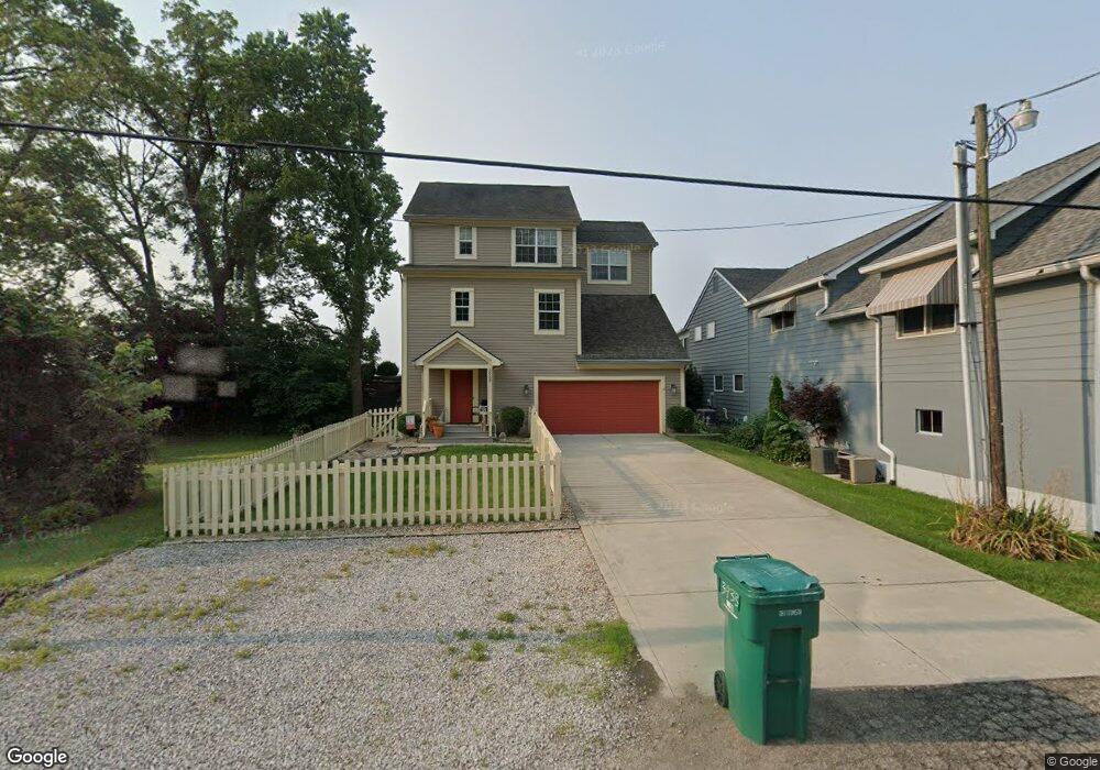
3933 N Bank Rd NE Millersport, OH 43046
Estimated Value: $544,000 - $969,000
3
Beds
2
Baths
2,082
Sq Ft
$372/Sq Ft
Est. Value
About This Home
This home is located at 3933 N Bank Rd NE, Millersport, OH 43046 and is currently estimated at $774,980, approximately $372 per square foot. 3933 N Bank Rd NE is a home located in Fairfield County with nearby schools including Millersport Elementary School and Millersport Jr/Sr High School.
Ownership History
Date
Name
Owned For
Owner Type
Purchase Details
Closed on
Nov 1, 2006
Sold by
Foor Roberta Jean
Bought by
Barbone Richard F and Barbone Mary Ann
Current Estimated Value
Home Financials for this Owner
Home Financials are based on the most recent Mortgage that was taken out on this home.
Original Mortgage
$220,000
Outstanding Balance
$130,424
Interest Rate
6.25%
Mortgage Type
Purchase Money Mortgage
Estimated Equity
$644,556
Purchase Details
Closed on
Jul 1, 1989
Create a Home Valuation Report for This Property
The Home Valuation Report is an in-depth analysis detailing your home's value as well as a comparison with similar homes in the area
Home Values in the Area
Average Home Value in this Area
Purchase History
| Date | Buyer | Sale Price | Title Company |
|---|---|---|---|
| Barbone Richard F | $275,000 | Attorney | |
| -- | $74,000 | -- |
Source: Public Records
Mortgage History
| Date | Status | Borrower | Loan Amount |
|---|---|---|---|
| Open | Barbone Richard F | $220,000 |
Source: Public Records
Tax History Compared to Growth
Tax History
| Year | Tax Paid | Tax Assessment Tax Assessment Total Assessment is a certain percentage of the fair market value that is determined by local assessors to be the total taxable value of land and additions on the property. | Land | Improvement |
|---|---|---|---|---|
| 2024 | $11,688 | $194,480 | $69,850 | $124,630 |
| 2023 | $7,320 | $194,480 | $69,850 | $124,630 |
| 2022 | $7,377 | $194,480 | $69,850 | $124,630 |
| 2021 | $5,938 | $143,020 | $58,210 | $84,810 |
| 2020 | $5,950 | $143,020 | $58,210 | $84,810 |
| 2019 | $5,950 | $143,020 | $58,210 | $84,810 |
| 2018 | $5,567 | $117,970 | $55,060 | $62,910 |
| 2017 | $5,568 | $122,400 | $55,060 | $67,340 |
| 2016 | $5,128 | $122,400 | $55,060 | $67,340 |
| 2015 | $5,070 | $119,280 | $55,060 | $64,220 |
| 2014 | $4,093 | $119,280 | $55,060 | $64,220 |
| 2013 | $4,093 | $119,280 | $55,060 | $64,220 |
Source: Public Records
Map
Nearby Homes
- 3863 N Bank Rd NE
- 4255 N Bank Rd NE
- 3483 N Bank Rd
- 3308 Shepard Ave
- 13556 Richards St NE
- 4468 N Bank Rd NE
- 4135 Walnut Rd
- 13474 W Bank Dr NE
- 13404 W Bank Dr NE
- 12700 Onion Island NE
- 4881 Decker Ave NE
- 13244 W Bank Dr NE
- 0 Beaver Rd NE
- 13180 W Bank Dr NE
- 13310 Shell Beach Rd NE
- 13309 Aspen Rd NE
- 0 Aspen Rd NE
- 4711 Walnut Rd Unit F2
- 5102 Bateson Beach Dr NE
- 5130 Bateson Dr NE
- 3923 N Bank Rd NE
- 3943 N Bank Rd NE
- 3913 N Bank Rd NE
- 3903 N Bank Rd NE
- 3924 N Bank Rd NE
- 3963 N Bank Rd
- 3893 N Bank Rd NE
- 3883 N Bank Rd NE
- 3973 N Bank Rd NE
- 3892 N Bank Rd NE
- 3892 N Bank Rd NE
- 3983 N Bank Rd NE
- 3873 N Bank Rd NE
- 3986 N Bank Rd NE
- 3915 Avalon Dr NE
- 13590 Grand Ave W
- 3975 Avalon Dr NE
- 13609 Grand Ave W
- 4003 N Bank Rd NE
- 13610 Grand Ave W