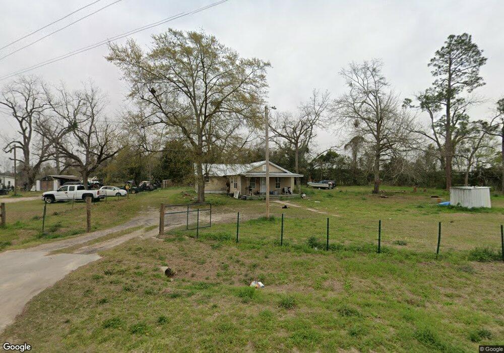
395 Ga Highway 45 S Colquitt, GA 39837
Estimated Value: $58,000 - $125,000
3
Beds
1
Bath
1,272
Sq Ft
$72/Sq Ft
Est. Value
About This Home
This home is located at 395 Ga Highway 45 S, Colquitt, GA 39837 and is currently estimated at $91,500, approximately $71 per square foot. 395 Ga Highway 45 S is a home located in Miller County with nearby schools including Miller County Elementary School, Miller County Middle School, and Miller County High School.
Ownership History
Date
Name
Owned For
Owner Type
Purchase Details
Closed on
Oct 1, 2024
Sold by
Doyle Jeanette
Bought by
Diego Francisco
Current Estimated Value
Purchase Details
Closed on
Sep 10, 2021
Sold by
Castro Alejandro
Bought by
Doyle Jeanette
Purchase Details
Closed on
Sep 9, 2021
Sold by
Nalls Jerry A
Bought by
Castro Alejandro
Purchase Details
Closed on
Aug 22, 2014
Sold by
Love Robert L
Bought by
Nalls Jerry A
Purchase Details
Closed on
Jul 11, 2002
Sold by
Worsley Talmadge
Bought by
Love Robert L & Mary F Love
Purchase Details
Closed on
Jun 11, 2001
Bought by
Worsley Talmadge
Create a Home Valuation Report for This Property
The Home Valuation Report is an in-depth analysis detailing your home's value as well as a comparison with similar homes in the area
Home Values in the Area
Average Home Value in this Area
Purchase History
| Date | Buyer | Sale Price | Title Company |
|---|---|---|---|
| Diego Francisco | $2,000 | -- | |
| Doyle Jeanette | -- | -- | |
| Castro Alejandro | $25,000 | -- | |
| Nalls Jerry A | $15,883 | -- | |
| Love Robert L & Mary F Love | $30,000 | -- | |
| Worsley Talmadge | -- | -- |
Source: Public Records
Tax History Compared to Growth
Tax History
| Year | Tax Paid | Tax Assessment Tax Assessment Total Assessment is a certain percentage of the fair market value that is determined by local assessors to be the total taxable value of land and additions on the property. | Land | Improvement |
|---|---|---|---|---|
| 2024 | $706 | $21,010 | $1,319 | $19,691 |
| 2023 | $569 | $15,980 | $1,319 | $14,661 |
| 2022 | $382 | $9,977 | $1,319 | $8,658 |
| 2021 | $398 | $10,511 | $1,319 | $9,192 |
| 2020 | $398 | $10,511 | $1,319 | $9,192 |
| 2019 | $399 | $10,511 | $1,319 | $9,192 |
| 2018 | $388 | $10,511 | $1,319 | $9,192 |
| 2017 | $388 | $10,511 | $1,319 | $9,192 |
| 2016 | $388 | $10,511 | $1,319 | $9,192 |
| 2015 | -- | $14,282 | $1,615 | $12,666 |
| 2014 | -- | $14,282 | $1,615 | $12,666 |
| 2013 | -- | $14,281 | $1,615 | $12,666 |
Source: Public Records
Map
Nearby Homes
- US 27 Us Highway 27
- 102 Bremond St
- 2835 Georgia 91
- 157 E Pine St
- 708 E Crawford St
- 356 E Main St
- 210 N First St
- 721 E Crawford St
- 570 E Pine St
- 000 Thompson Town Rd
- 300 N First St
- 000 Bellview Rd
- 1645 Georgia 91
- 1502 Brinson Rd
- 000 Phillipsburg Rd
- 994 Hornsby Rd
- 1203 Bellview Rd
- 755 Mayhaw Rd
- 1563 Ga Highway 27 N
- 113 Crooked Oak Ln
- 407 Ga Highway 45 S
- 15 Drew Floyd Rd
- 387 Ga Highway 45 S
- 408 Ga Highway 45 S
- 408 Ga Highway 45 S
- 364 Ga Highway 45 S
- 21 Drew Floyd Rd
- 360 Ga Highway 45 S
- 424 Ga Highway 45 S
- 356 Ga Highway 45 S
- 427 Ga Highway 45 S
- 352 Ga Highway 45 S
- 327 Ga Highway 45 S
- 77 Drew Floyd Rd
- 35 Hornsby Rd
- 283 Ga Highway 45 S
- 288 Ga Highway 45 S
- 322 Grimsley Bridge Rd
- 511 Ga Highway 45 S
- 265 Ga Highway 45 S