


396 Maple St Hinsdale, MA 01235
Estimated payment $2,692/month
Highlights
- Colonial Architecture
- Deck
- Stone Countertops
- View of Hills
- Wood Flooring
- Mature Landscaping
About This Home
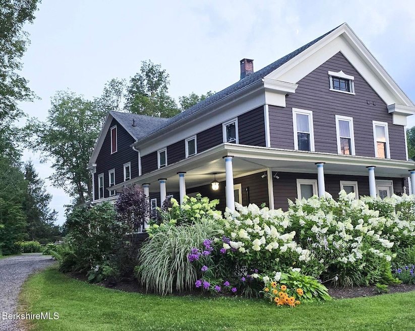
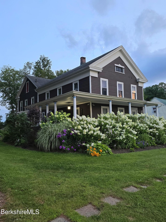
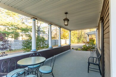
Charming 6-Bedroom New England Farmhouse in Hinsdale, MASet on a peaceful 3/4-acre lot in the heart of the Berkshires, this spacious and thoughtfully updated 6-bedroom farmhouse offers the perfect blend of classic charm and modern comfort.A welcoming wrap-around porch invites you to relax and enjoy the quiet rural surroundings. Inside, the first floor features an expansive modern kitchen, formal dining room, living room, office, half bath, and a versatile bedroom or family room--designed for both everyday living and entertaining.Upstairs, you'll find five additional bedrooms, two full bathrooms, and an office or potential seventh bedroom.Recent updates include full insulation, newer windows, newer roof, updated electrical, solar panels, professionally landscaped
Listing Agent
REALTY STREET, LLC Brokerage Phone: 413-822-1571 License #9017791 Listed on: 10/22/2025
Home Details
Home Type
- Single Family
Est. Annual Taxes
- $3,363
Year Built
- 1840
Lot Details
- 0.75 Acre Lot
- Lot Dimensions are 85' x 340'
- Mature Landscaping
Home Design
- Colonial Architecture
- Wood Frame Construction
- Asphalt Shingled Roof
- Wood Siding
Interior Spaces
- 3,315 Sq Ft Home
- ENERGY STAR Qualified Windows
- Insulated Windows
- Insulated Doors
- Views of Hills
- Unfinished Basement
- Basement Fills Entire Space Under The House
Kitchen
- Range
- Microwave
- Dishwasher
- Stone Countertops
Flooring
- Wood
- Carpet
- Laminate
- Ceramic Tile
Bedrooms and Bathrooms
- 6 Bedrooms
Laundry
- Dryer
- Washer
Parking
- 2 Car Detached Garage
- Automatic Garage Door Opener
- Off-Street Parking
Outdoor Features
- Deck
- Porch
Schools
- Kittredge Elementary School
- Nessacus Regional Middle School
- Wahconah Regional High School
Utilities
- Zoned Heating and Cooling
- Ductless Heating Or Cooling System
- Heating System Uses Steam
- Heating System Uses Oil
- Electric Water Heater
- Cable TV Available
Community Details
- Public Transportation
Map
Home Values in the Area
Average Home Value in this Area
Tax History
| Year | Tax Paid | Tax Assessment Tax Assessment Total Assessment is a certain percentage of the fair market value that is determined by local assessors to be the total taxable value of land and additions on the property. | Land | Improvement |
|---|---|---|---|---|
| 2025 | $3,363 | $301,600 | $33,700 | $267,900 |
| 2024 | $3,245 | $295,300 | $33,700 | $261,600 |
| 2023 | $3,277 | $242,900 | $32,300 | $210,600 |
| 2022 | $3,079 | $225,400 | $32,300 | $193,100 |
| 2021 | $3,511 | $245,000 | $37,700 | $207,300 |
| 2020 | $3,276 | $248,000 | $37,700 | $210,300 |
| 2019 | $3,288 | $249,300 | $37,700 | $211,600 |
| 2017 | $3,368 | $239,000 | $37,700 | $201,300 |
| 2016 | $3,203 | $239,000 | $37,700 | $201,300 |
| 2015 | $2,449 | $207,200 | $39,700 | $167,500 |
| 2014 | $2,563 | $200,700 | $41,700 | $159,000 |
Property History
| Date | Event | Price | List to Sale | Price per Sq Ft |
|---|---|---|---|---|
| 12/09/2025 12/09/25 | Pending | -- | -- | -- |
| 10/22/2025 10/22/25 | For Sale | $459,900 | -- | $139 / Sq Ft |
Purchase History
| Date | Type | Sale Price | Title Company |
|---|---|---|---|
| Quit Claim Deed | -- | None Available | |
| Quit Claim Deed | -- | None Available | |
| Not Resolvable | $320,000 | -- | |
| Deed | $192,000 | -- | |
| Deed | $175,000 | -- |
Mortgage History
| Date | Status | Loan Amount | Loan Type |
|---|---|---|---|
| Previous Owner | $256,000 | New Conventional | |
| Previous Owner | $153,600 | Purchase Money Mortgage |
Source: Berkshire County Board of REALTORS®
MLS Number: 248062
APN: HINS-000109-000000-000003
Disclaimer: Certain information contained herein is derived from information provided by parties other than Homes.com. All information provided is deemed reliable, but is not guaranteed to be accurate and should be independently verified.
![]() IDX information is provided exclusively for consumers' personal, non-commercial use, that it may not be used for any purpose other than to identify prospective properties consumers may be interested in purchasing. Information deemed to be reliable but not guaranteed.
IDX information is provided exclusively for consumers' personal, non-commercial use, that it may not be used for any purpose other than to identify prospective properties consumers may be interested in purchasing. Information deemed to be reliable but not guaranteed.
The data relating to real estate for sale on this website comes from Berkshire County Board of Realtors and the Broker Reciprocity Program.
Copyright 2025 Berkshire County Board of Realtors. All rights reserved.
- 469 Maple St
- 1 Maple St
- 103 Holmes Rd
- 139 Longview Ave
- 715 Peru Rd
- 30 Cove Ln
- 14 & 15 George Schnopp Rd
- 30 Eagle St
- 190 Fox Rd
- 567 George Schnopp Rd
- 0 Forest Hill Dr Lots 8 & 9 --
- 14 Blotz Rd
- 65 Johnson Rd
- 218 Johnson Rd
- 48 Mountain View Terrace
- 1109 Washington Rd Unit 10 on Alice Dr.
- 9 Greylock Cir
- 249 Orchard Rd
- 4 Birch Hill Rd
- 774 Main St
