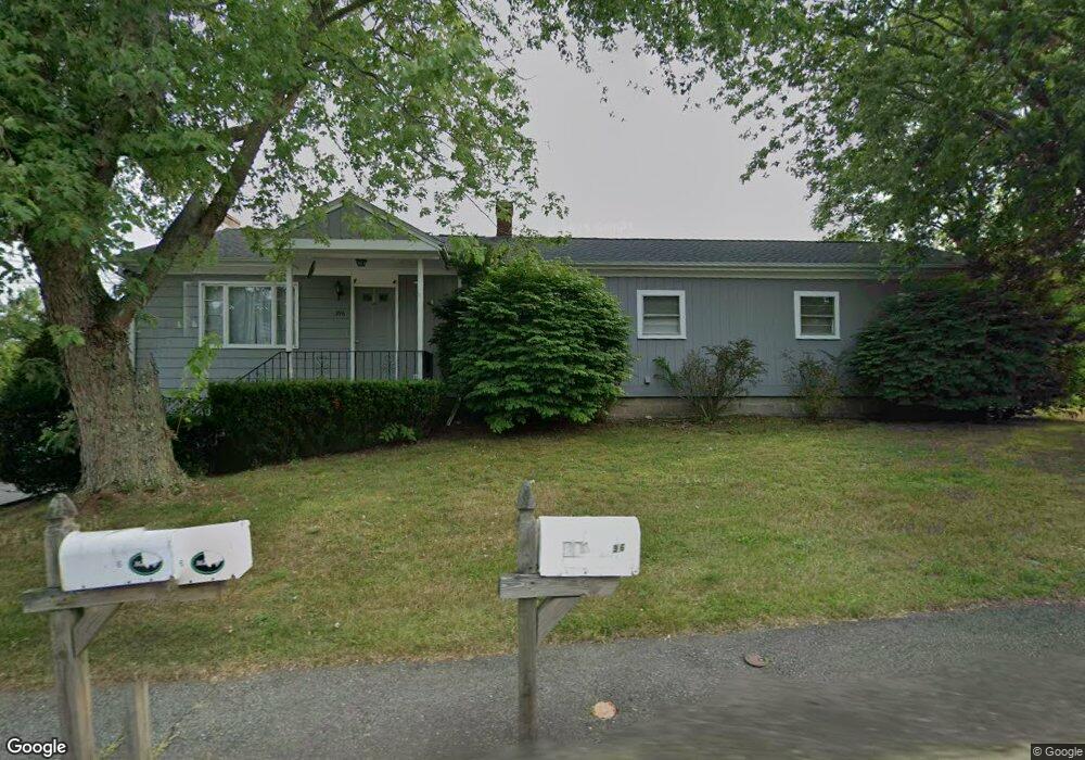
396 West St Mansfield, MA 02048
Estimated Value: $552,000 - $687,000
3
Beds
1
Bath
1,312
Sq Ft
$462/Sq Ft
Est. Value
About This Home
This home is located at 396 West St, Mansfield, MA 02048 and is currently estimated at $605,490, approximately $461 per square foot. 396 West St is a home located in Bristol County with nearby schools including Everett W. Robinson Elementary School, Jordan/Jackson Elementary School, and Harold L. Qualters Middle School.
Ownership History
Date
Name
Owned For
Owner Type
Purchase Details
Closed on
Apr 30, 1991
Sold by
Whittier Ruth A
Bought by
Clemmey Elizabeth A
Current Estimated Value
Home Financials for this Owner
Home Financials are based on the most recent Mortgage that was taken out on this home.
Original Mortgage
$50,000
Interest Rate
9.41%
Mortgage Type
Purchase Money Mortgage
Create a Home Valuation Report for This Property
The Home Valuation Report is an in-depth analysis detailing your home's value as well as a comparison with similar homes in the area
Home Values in the Area
Average Home Value in this Area
Purchase History
| Date | Buyer | Sale Price | Title Company |
|---|---|---|---|
| Clemmey Elizabeth A | $150,000 | -- |
Source: Public Records
Mortgage History
| Date | Status | Borrower | Loan Amount |
|---|---|---|---|
| Closed | Clemmey Elizabeth A | $50,000 |
Source: Public Records
Tax History Compared to Growth
Tax History
| Year | Tax Paid | Tax Assessment Tax Assessment Total Assessment is a certain percentage of the fair market value that is determined by local assessors to be the total taxable value of land and additions on the property. | Land | Improvement |
|---|---|---|---|---|
| 2025 | $5,873 | $445,900 | $251,300 | $194,600 |
| 2024 | $5,531 | $409,700 | $251,300 | $158,400 |
| 2023 | $5,484 | $389,200 | $251,300 | $137,900 |
| 2022 | $5,366 | $353,700 | $234,400 | $119,300 |
| 2021 | $5,302 | $345,200 | $214,500 | $130,700 |
| 2020 | $5,242 | $341,300 | $214,500 | $126,800 |
| 2019 | $4,797 | $315,200 | $181,800 | $133,400 |
| 2018 | $4,278 | $284,200 | $166,600 | $117,600 |
| 2017 | $4,305 | $286,600 | $162,500 | $124,100 |
| 2016 | $4,358 | $282,800 | $162,600 | $120,200 |
| 2015 | $3,966 | $255,900 | $155,500 | $100,400 |
Source: Public Records
Map
Nearby Homes
- 450 West St
- 132 S High St
- 150 Rumford Ave Unit 222
- 241-243 N Main St
- 115 S High St
- 16 Bradner St
- 22 Pleasant St Unit B
- 22 Pleasant St Unit A
- 28 Court St
- 28 Court St Unit 4
- 356 Central St
- 16 East St Unit 2
- 38 Court St
- 21 East St Unit 1D
- 72 Court St Unit B
- 76 Samoset Ave
- 12 Wilson Place
- 28 Angell St
- 60 King St
- 99 Pleasant St
- 399 West St
- 395 West St
- 407 West St
- 401 West St
- 430 West St
- 8 S Walnut St
- 5 Walnut St
- 0 West St Unit 71302422
- 0 West St Unit 71314522
- 0 West St Unit 71323194
- 0 West St Unit 71410331
- 0 West St Unit LOT 71794286
- 0 West St
- 0 West St Unit 30446413
- 18 S Walnut St
- 15 Walnut St
- 375 West St
- 427 West St
- 36 Casa Dr
- 25 Walnut St