NOT LISTED FOR SALE

397 Mckean Ave West Fork, AR 72774

Estimated Value: $233,000 - $497,000

40.11 Acres
$8,475 Price per Acre
1,747,192 Sq Ft Lot

Last Sold December 29, 2023

Last sale price $415,000 $306 Per Sq Ft

Est. 18% decrease in value since last sale

Current estimated payment $1,907/month

Highlights

  • 40.11 Acre Lot
  • Wooded Lot
  • Level Lot
  • Pond
  • Views

About This Lot

As of December 2023

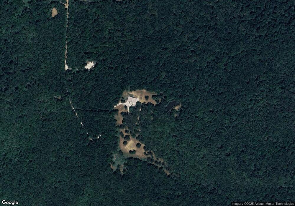
Beautiful 40+ acres situated within the Boston Mountains. Great view, approximately 1/3 cleared & the remaining includes mature hardwoods. Majority of the property is level and buildable. Two ponds, well, and electric on site.

Last Agent to Sell the Property

NON MLS Fort Smith

NON MLS License #0 Listed on: 12/29/2023

Last Buyer's Agent

Kelci Fulmer

Jim White Realty License #SA00080649

Property Details

Property Type

  • Land

Est. Annual Taxes

  • $750

Lot Details

  • 40.11 Acre Lot
  • Level Lot
  • Wooded Lot
  • Landscaped with Trees

Schools

  • West Fork Elementary And Middle School
  • West Fork High School

Additional Features

  • Pond
  • Well
  • Property Views

Listing and Financial Details

  • Assessor Parcel Number 001-03115-000

Property Details

Property Type

Land

Est. Annual Taxes

$750

Lot Details

0

Listing Details

  • Prop. Type: Land
  • ResoLotFeatures: Hardwood Trees, Views, Level, Pond, Steep Slope, Wooded
  • Co List Office Mls Id: 9991
  • Subdivision Name: 0
  • Directions: From i49, take exit 53,merge onto AR 170 E, Left onto 170, Right onto Hwy 71 S, Left onto Roberts ST. Property at the very end of the private road.
  • Special Features: None
  • Property Sub Type: LotsLands

Exterior Features

  • Fencing: None
  • Acres: 40.11
  • Topography: Level
  • View: Yes

Utilities

  • Electricity On Property: Yes
  • Utilities: Electricity Available
  • Water Source: Well

Schools

  • Ninth Grade High School: West Fork
  • Middle Or Junior School: West Fork

Lot Info

  • Lot Dimensions: 0
  • ResoLotSizeUnits: Acres
  • Parcel #: 001-03115-000
  • ResoLotSizeUnits: Acres

Tax Info

  • Tax Annual Amount: 750.0
  • Tax Block: 0
  • Tax Lot: 0

MLS Schools

  • Elementary School: West Fork

Ownership History

Date Name Owned For Owner Type

Purchase Details

Closed on
Dec 29, 2004
Sold by
Elam Paula J
Bought by
Higginbottom Marvelous Marve and Higginbottom Candice
Current Estimated Value
$339,919

Home Financials for this Owner

Home Financials are based on the most recent Mortgage that was taken out on this home.
Original Mortgage
$104,000
Outstanding Balance
$51,284
Interest Rate
5.5%
Mortgage Type
Purchase Money Mortgage
Estimated Equity
$288,635

Purchase Details

Closed on
Feb 14, 1997
Bought by
Elam Paula and Atkins Marilyn S

Purchase Details

Closed on
May 22, 1995
Bought by
Elam Paula

Purchase Details

Closed on
Aug 14, 1991
Bought by
Snodgrass Ray R and Mary Lou

Purchase Details

Closed on
Jul 7, 1987
Bought by
Newman Linda Lucero

Purchase Details

Closed on
Jan 1, 1985
Bought by
Fleener Fleener T and Fleener Elizabeth H
Source: Public Records

Range of Values:

--
Value Increase
--
Percent Increase
--
Adjusted for Inflation
Collateral Analytics

Collateral Analytics Collateral Analytics AVMs (Automated Valuation Model) employ a number of statistical approaches combined with neighborhood-specific comparable selection guarantees the most up-to-date and precise valuations.

Not Available

Collateral Analytics does not have data for the current month. Please view the chart for historical values.

ICE

ICE Mortgage Technology ICE Mortgage Technology’s AVM (Automated Valuation Model) is a state-of-the-art online residential property valuation tool that provides a quick and accurate estimate of the value of almost any home in the U.S.

Not Available

ICE Mortgage Technology does not have data for the current month. Please view the chart for historical values.

First American

First American First American Data & Analytics’ next-generation AVM combines unrivaled data assets with a blended ensemble of valuation models to produce highly accurate, reliable valuations you can trust.

Not Available

First American does not have data for the current month. Please view the chart for historical values.

Quantarium

Quantarium Quantarium’s valuation service, repeatedly proven the industry’s most accurate and comprehensive, is supercharged with a self-learning and auto-tuning AI engine that continually becomes smarter and more accurate as it processes daily inputs from the industry’s leading RE data lake.

Not Available

Quantarium does not have data for the current month. Please view the chart for historical values.

Average Value
Not Available
List Price
Sold Price
Create a Home Valuation Report for This Property
The Home Valuation Report is an in-depth analysis detailing your home's value as well as a comparison with similar homes in the area

Home Values in the Area

Source: Public Records

Average Home Value in this Area


Source: Public Records

Purchase History

Date Buyer Sale Price Title Company
Higginbottom Marvelous Marve $130,000 --
Elam Paula -- --
Elam Paula $83,000 --
Snodgrass Ray R $55,000 --
Newman Linda Lucero $60,000 --
Fleener Fleener T -- --
Source: Public Records

Mortgage History

Date Status Borrower Loan Amount
Open Higginbottom Marvelous Marve $104,000
Source: Public Records

Property History

Date Event Price List to Sale Price per Sq Ft Prior Sale
12/29/2023 12/29/23 Sold $415,000 0.0% $306 / Sq Ft
12/07/2023 12/07/23 Sold $415,000 -17.0% $306 / Sq Ft View Prior Sale
10/30/2023 10/30/23 Pending -- -- --
07/10/2023 07/10/23 For Sale $499,900 -- $368 / Sq Ft
Source: Western River Valley Board of REALTORS®

Tax History Compared to Growth

Source: Public Records

Tax History

Year Tax Paid Tax Assessment Tax Assessment Total Assessment is a certain percentage of the fair market value that is determined by local assessors to be the total taxable value of land and additions on the property. Land Improvement
2025 $1,347 $28,130 $6,350 $21,780
2024 $886 $18,490 $6,340 $12,150
2023 $761 $18,490 $6,340 $12,150
2022 $750 $14,500 $5,090 $9,410
2021 $697 $14,500 $5,090 $9,410
2020 $644 $14,500 $5,090 $9,410
2019 $590 $11,070 $3,470 $7,600
2018 $590 $11,070 $3,470 $7,600
2017 $516 $11,070 $3,470 $7,600
2016 $574 $11,070 $3,470 $7,600
2015 $524 $11,070 $3,470 $7,600
2014 $729 $15,490 $7,050 $8,440
Source: Public Records

Agents Affiliated with this Home

  • Section Image
  • Section Image
See All Agents

Map

Source: Western River Valley Board of REALTORS®

MLS Number: 1069642

APN: 001-03115-000