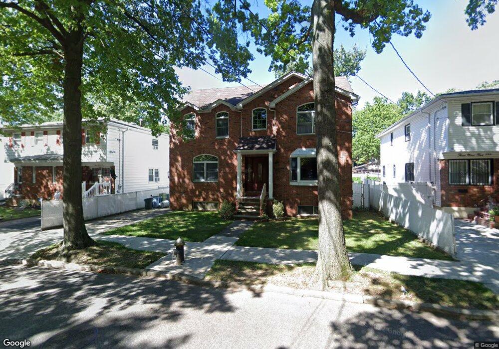
397 N Railroad Ave Staten Island, NY 10304
Dongan Hills NeighborhoodEstimated Value: $993,116 - $1,185,000
--
Bed
4
Baths
2,552
Sq Ft
$420/Sq Ft
Est. Value
About This Home
This home is located at 397 N Railroad Ave, Staten Island, NY 10304 and is currently estimated at $1,071,029, approximately $419 per square foot. 397 N Railroad Ave is a home located in Richmond County with nearby schools including P.S. 11 Thomas Dongan School, Is 2 George L Egbert, and New Dorp High School.
Ownership History
Date
Name
Owned For
Owner Type
Purchase Details
Closed on
Nov 26, 1997
Sold by
Ambio Frances A and Carter Frances M
Bought by
Cender Karen
Current Estimated Value
Home Financials for this Owner
Home Financials are based on the most recent Mortgage that was taken out on this home.
Original Mortgage
$85,000
Outstanding Balance
$14,266
Interest Rate
7.14%
Estimated Equity
$1,056,763
Create a Home Valuation Report for This Property
The Home Valuation Report is an in-depth analysis detailing your home's value as well as a comparison with similar homes in the area
Home Values in the Area
Average Home Value in this Area
Purchase History
| Date | Buyer | Sale Price | Title Company |
|---|---|---|---|
| Cender Karen | $125,000 | Inter County Title Guaranty |
Source: Public Records
Mortgage History
| Date | Status | Borrower | Loan Amount |
|---|---|---|---|
| Open | Cender Karen | $85,000 |
Source: Public Records
Tax History Compared to Growth
Tax History
| Year | Tax Paid | Tax Assessment Tax Assessment Total Assessment is a certain percentage of the fair market value that is determined by local assessors to be the total taxable value of land and additions on the property. | Land | Improvement |
|---|---|---|---|---|
| 2025 | $8,882 | $68,100 | $8,862 | $59,238 |
| 2024 | $8,894 | $58,860 | $9,673 | $49,187 |
| 2023 | $8,981 | $45,622 | $8,273 | $37,349 |
| 2022 | $8,752 | $68,820 | $12,480 | $56,340 |
| 2021 | $8,686 | $63,360 | $12,480 | $50,880 |
| 2020 | $8,154 | $54,660 | $12,480 | $42,180 |
| 2019 | $7,660 | $50,040 | $12,480 | $37,560 |
| 2018 | $7,452 | $38,018 | $11,185 | $26,833 |
| 2017 | $7,392 | $37,731 | $9,701 | $28,030 |
| 2016 | $6,806 | $35,596 | $10,073 | $25,523 |
| 2015 | $5,775 | $33,582 | $9,078 | $24,504 |
| 2014 | $5,775 | $31,682 | $9,450 | $22,232 |
Source: Public Records
Map
Nearby Homes
- 2 Remsen St
- 32 Remsen St
- 0 Hylan Blvd Unit 2405533
- 0 Hylan Blvd Unit 11348978
- 453 N Railroad Ave
- 169 Atlantic Ave
- 166 Providence St
- 141 Evergreen Ave Unit 2a
- 46 Durges St
- 102 Burgher Ave
- 34 Bear St
- 41 Newberry Ave
- 57 Jerome Rd
- 119 Raritan Ave
- 125 Laconia Ave
- 286 Raritan Ave
- 137 Delaware Ave
- 1160 Richmond Rd Unit 7B
- 1160 Richmond Rd Unit 6A
- 1160 Richmond Rd Unit 2F
- 395 N Railroad Ave
- 403 N Railroad Ave
- 393 N Railroad Ave
- 405 N Railroad Ave
- 407 N Railroad Ave
- 391 N Railroad Ave
- 18 Minna St
- 389 N Railroad Ave
- 14 Minna St
- 411 N Railroad Ave
- 24 Minna St
- 413 N Railroad Ave
- 8 Minna St
- 30 Minna St
- 398 N Railroad Ave
- 402 N Railroad Ave
- 62 Cornelia St
- 62 Cornelia St Unit 2
- 66 Cornelia St
- 396 N Railroad Ave