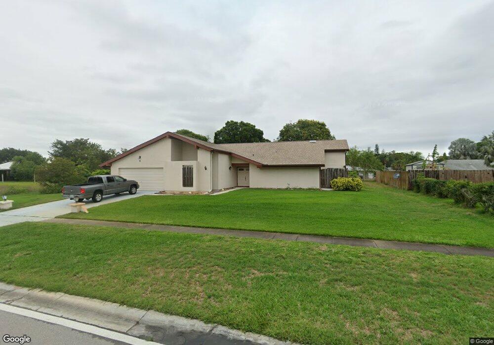
397 Port Malabar Blvd NE Palm Bay, FL 32905
Port Malabar NeighborhoodEstimated Value: $349,554 - $380,000
3
Beds
2
Baths
2,255
Sq Ft
$163/Sq Ft
Est. Value
About This Home
This home is located at 397 Port Malabar Blvd NE, Palm Bay, FL 32905 and is currently estimated at $368,389, approximately $163 per square foot. 397 Port Malabar Blvd NE is a home located in Brevard County with nearby schools including Riviera Elementary School, Stone Magnet Middle School, and Palm Bay Magnet Senior High School.
Ownership History
Date
Name
Owned For
Owner Type
Purchase Details
Closed on
Dec 30, 2004
Sold by
Hilaire Victor
Bought by
Study Samuel
Current Estimated Value
Home Financials for this Owner
Home Financials are based on the most recent Mortgage that was taken out on this home.
Original Mortgage
$84,250
Outstanding Balance
$42,170
Interest Rate
5.62%
Estimated Equity
$326,219
Create a Home Valuation Report for This Property
The Home Valuation Report is an in-depth analysis detailing your home's value as well as a comparison with similar homes in the area
Home Values in the Area
Average Home Value in this Area
Purchase History
| Date | Buyer | Sale Price | Title Company |
|---|---|---|---|
| Study Samuel | $115,000 | Southern Title & Abstract In |
Source: Public Records
Mortgage History
| Date | Status | Borrower | Loan Amount |
|---|---|---|---|
| Open | Study Samuel | $84,250 |
Source: Public Records
Tax History Compared to Growth
Tax History
| Year | Tax Paid | Tax Assessment Tax Assessment Total Assessment is a certain percentage of the fair market value that is determined by local assessors to be the total taxable value of land and additions on the property. | Land | Improvement |
|---|---|---|---|---|
| 2025 | $1,244 | $107,410 | -- | -- |
| 2024 | $1,201 | $104,390 | -- | -- |
| 2023 | $1,201 | $101,350 | $0 | $0 |
| 2022 | $1,128 | $98,400 | $0 | $0 |
| 2021 | $1,134 | $95,540 | $0 | $0 |
| 2020 | $1,016 | $89,630 | $0 | $0 |
| 2019 | $1,215 | $87,620 | $0 | $0 |
| 2018 | $1,189 | $85,990 | $0 | $0 |
| 2017 | $1,210 | $84,230 | $0 | $0 |
| 2016 | $954 | $82,500 | $11,000 | $71,500 |
| 2015 | $970 | $81,930 | $11,000 | $70,930 |
| 2014 | $969 | $81,280 | $11,000 | $70,280 |
Source: Public Records
Map
Nearby Homes
- 1496 Scepter Ct NE
- 498 Port Malabar Blvd NE
- 1351 Cherry Hills Rd NE
- 1184 Hooper Ave NE
- 296 Port Malabar Blvd NE
- 1204 Riviera Dr NE
- 1034 Connolly Ln NE
- 1004 Connolly Ln NE
- 1564 Satinwood Ct NE
- 933 Waialae Cir NE
- 1360 Cindy Cir NE
- 1432 Voyager St NE
- 3612 Tree Ridge Ln NE
- 1626 Riviera Dr NE
- 1281 Dawn St NE
- 1638 Riviera Dr NE
- 1124 Eleuthera Dr NE
- 914 Waialae Cir NE
- 2101 Forest Knoll Dr NE Unit 1-101
- 2190 Forest Knoll Dr NE Unit 90-104
- 401 Port Malabar Blvd NE
- 1406 Krin Ct NE
- 1211 Miro Ct NE
- 1424 Krin Ct NE
- 415 Port Malabar Blvd NE
- 396 Port Malabar Blvd NE
- 1442 Krin Ct NE
- 400 Port Malabar Blvd NE
- 1407 Krin Ct NE
- 1398 Cherry Hills Rd NE
- 1298 Miro Ct NE
- 1460 Krin Ct NE
- 427 Port Malabar Blvd NE
- 393 Miro Ct NE
- 1254 Miro Ct NE
- 1449 Scepter Ct NE
- 1443 Krin Ct NE
- 1425 Scepter Ct NE
- 1390 Cherry Hills Rd NE
- 1425 Krin Ct NE