Estimated Value: $287,000 - $354,000
3
Beds
2
Baths
2,322
Sq Ft
$142/Sq Ft
Est. Value
About This Home
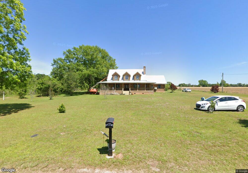
This home is located at 3972 Range Rd, Jay, FL 32565 and is currently estimated at $329,747, approximately $142 per square foot. 3972 Range Rd is a home with nearby schools including Jay Elementary School, Jay High School, and Faith Christian Academy.
Ownership History
Date
Name
Owned For
Owner Type
Purchase Details
Closed on
Apr 12, 2022
Sold by
Dobson Roger Matthew and Dobson Teresa
Bought by
Simmons Anthony Charles and Simmons Amanda L
Current Estimated Value
Purchase Details
Closed on
Oct 8, 2021
Sold by
Simmons Anthony Charles and Simmons Amanda L
Bought by
Dobson Roger Matthew and Dobson Teresa
Home Financials for this Owner
Home Financials are based on the most recent Mortgage that was taken out on this home.
Original Mortgage
$218,762
Interest Rate
2.8%
Mortgage Type
New Conventional
Create a Home Valuation Report for This Property
The Home Valuation Report is an in-depth analysis detailing your home's value as well as a comparison with similar homes in the area
Purchase History
| Date | Buyer | Sale Price | Title Company |
|---|---|---|---|
| Simmons Anthony Charles | $100 | -- | |
| Simmons Anthony Charles | $100 | None Listed On Document | |
| Dobson Roger Matthew | $215,000 | Attorney |
Source: Public Records
Mortgage History
| Date | Status | Borrower | Loan Amount |
|---|---|---|---|
| Previous Owner | Dobson Roger Matthew | $218,762 |
Source: Public Records
Tax History
| Year | Tax Paid | Tax Assessment Tax Assessment Total Assessment is a certain percentage of the fair market value that is determined by local assessors to be the total taxable value of land and additions on the property. | Land | Improvement |
|---|---|---|---|---|
| 2025 | $2,576 | $255,577 | $7,028 | $248,549 |
| 2024 | $2,588 | $250,113 | $6,024 | $244,089 |
| 2023 | $2,588 | $247,728 | $6,024 | $241,704 |
| 2022 | $2,602 | $246,697 | $5,522 | $241,175 |
| 2021 | $1,601 | $157,643 | $0 | $0 |
| 2020 | $1,585 | $155,482 | $0 | $0 |
| 2019 | $1,548 | $152,011 | $0 | $0 |
| 2018 | $1,539 | $149,197 | $0 | $0 |
| 2017 | $1,466 | $146,151 | $0 | $0 |
| 2016 | $1,458 | $143,168 | $0 | $0 |
| 2015 | $1,402 | $142,150 | $0 | $0 |
| 2014 | $1,500 | $140,999 | $0 | $0 |
Source: Public Records
Map
Nearby Homes
- 13072 Chumuckla Hwy
- 3675 Hazel Godwin Rd
- 3351 N Simmons Rd
- 3364 N Simmons Rd
- 3332 N Simmons Rd
- 3401 Rocky Rd
- 4363 Morristown Rd
- 0000 Rocky Rd
- 3549 Godwin Rd
- 0000 Morristown Rd Unit LOT B
- 2360 Trudy Ln
- 2779 Nelsontown Rd
- 2750 Nelsontown Rd
- 0 Shell Rd
- 4660 Morristown Rd
- 00 Dykestown Rd
- 3090 Florida 4
- 13750 Florida 89
- 11 Bud Diamond Rd
- 9107 Pine Preserve Ln
- 2918 Lakefield Ln
- 3907 Range Rd
- 4070 Range Rd
- 3921 N Simmons Rd
- 4037 N Simmons Rd
- 3903 N Simmons Rd
- 4067 N Simmons Rd
- 12990 Chumuckla Hwy
- 4075 N Simmons Rd
- 3839 N Simmons Rd N
- 13034 Chumuckla Hwy
- 4106 Range Rd
- 4087 N Simmons Rd
- 12980 Chumuckla Hwy
- 12984 Chumuckla Hwy
- 4093 N Simmons Rd
- 12976 Chumuckla Hwy
- 4018 Hazel Godwin Rd
- 13030 Chumuckla Hwy
- 4040 N Simmons Rd
Your Personal Tour Guide
Ask me questions while you tour the home.