
Seller's Agent in 2025
Abigail Chessie
Real Estate 2000 ME/NH
(207) 502-3469
28 in this area
170 Total Sales
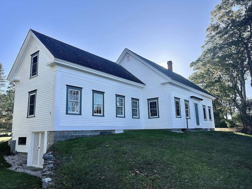
Charming 1850's farmhouse on 29 acres. Home features 3 bedrooms, 1 bath, open kitchen/dining area and three season porch.
| Date | Type | Sale Price | Title Company |
|---|---|---|---|
| Warranty Deed | $375,000 | -- | |
| Personal Reps Deed | -- | -- | |
| Personal Reps Deed | -- | -- |
| Date | Status | Loan Amount | Loan Type |
|---|---|---|---|
| Previous Owner | $66,320 | Commercial |
| Date | Event | Price | List to Sale | Price per Sq Ft |
|---|---|---|---|---|
| 10/16/2025 10/16/25 | For Sale | $375,000 | 0.0% | $221 / Sq Ft |
| 10/15/2025 10/15/25 | Sold | $375,000 | -- | $221 / Sq Ft |
| 03/10/2025 03/10/25 | Pending | -- | -- | -- |
| Year | Tax Paid | Tax Assessment Tax Assessment Total Assessment is a certain percentage of the fair market value that is determined by local assessors to be the total taxable value of land and additions on the property. | Land | Improvement |
|---|---|---|---|---|
| 2025 | $2,004 | $118,594 | $55,355 | $63,239 |
| 2024 | $1,994 | $118,700 | $55,461 | $63,239 |
| 2023 | $1,941 | $119,842 | $56,603 | $63,239 |
| 2022 | $1,887 | $121,736 | $58,497 | $63,239 |
| 2021 | $1,883 | $121,846 | $58,607 | $63,239 |
| 2020 | $1,854 | $122,378 | $59,139 | $63,239 |
| 2019 | $1,821 | $122,216 | $58,977 | $63,239 |
| 2017 | $2,325 | $121,960 | $58,721 | $63,239 |
| 2016 | $2,216 | $121,589 | $58,350 | $63,239 |
| 2015 | $1,784 | $118,940 | $55,701 | $63,239 |
| 2013 | $1,740 | $119,149 | $55,910 | $63,239 |
Seller's Agent in 2025
Abigail Chessie
Real Estate 2000 ME/NH
(207) 502-3469
28 in this area
170 Total Sales
Source: Maine Listings
MLS Number: 1640969
APN: PARS-000014R-000000-000015
Disclaimer: Certain information contained herein is derived from information provided by parties other than Homes.com. All information provided is deemed reliable, but is not guaranteed to be accurate and should be independently verified.
![]() Listing data is derived in whole or in part from Maine Real Estate Information System, Inc. (d/b/a Maine Listings) and is for consumers' personal, noncommercial use only. Dimensions are approximate and not guaranteed. All data should be independently verified.
Listing data is derived in whole or in part from Maine Real Estate Information System, Inc. (d/b/a Maine Listings) and is for consumers' personal, noncommercial use only. Dimensions are approximate and not guaranteed. All data should be independently verified.
© 2026 Maine Real Estate Information System, Inc. All Rights Reserved. Equal Housing Opportunity.
Homes.com, LLC, 17600 Laguna Canyon Rd Irvine, CA 92618 (888)-952-6393
![]()
Ask me questions while you tour the home.