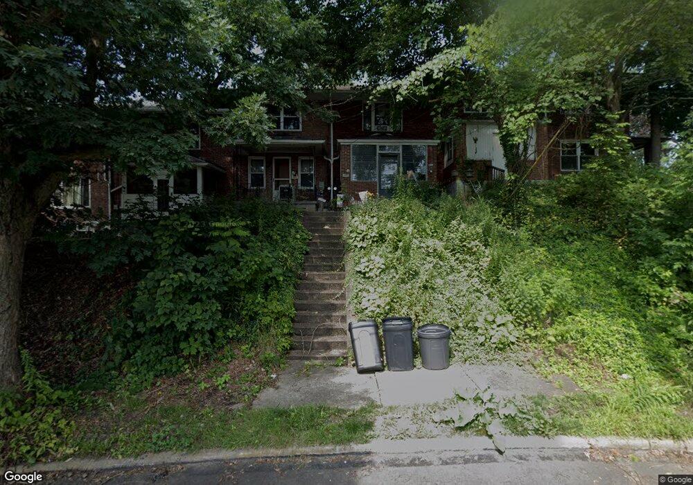
398 Ohio Ave Clairton, PA 15025
Estimated Value: $25,000 - $44,980
2
Beds
1
Bath
832
Sq Ft
$45/Sq Ft
Est. Value
About This Home
This home is located at 398 Ohio Ave, Clairton, PA 15025 and is currently estimated at $37,745, approximately $45 per square foot. 398 Ohio Ave is a home located in Allegheny County with nearby schools including Clairton Elementary School, Clairton Middle School/High School, and Cornerstone Leadership Academy.
Ownership History
Date
Name
Owned For
Owner Type
Purchase Details
Closed on
Aug 2, 2022
Sold by
Mccormick William Est and Mccormick William L Est
Bought by
Mccormick Scott J
Current Estimated Value
Purchase Details
Closed on
Jan 21, 2022
Sold by
Mccormick William L
Bought by
Mccormick Scott J
Purchase Details
Closed on
Mar 22, 2013
Sold by
Papula Marie
Bought by
Mccormick William L
Purchase Details
Closed on
Dec 10, 2007
Sold by
Greggco Inc
Bought by
Papula Marie
Purchase Details
Closed on
Dec 8, 2006
Sold by
Havrilla Anna
Bought by
Greggco Inc
Create a Home Valuation Report for This Property
The Home Valuation Report is an in-depth analysis detailing your home's value as well as a comparison with similar homes in the area
Home Values in the Area
Average Home Value in this Area
Purchase History
| Date | Buyer | Sale Price | Title Company |
|---|---|---|---|
| Mccormick Scott J | -- | -- | |
| Mccormick Scott J | -- | -- | |
| Mccormick Scott J | -- | -- | |
| Mccormick William L | $14,000 | -- | |
| Papula Marie | $15,627 | -- | |
| Greggco Inc | $16,000 | -- |
Source: Public Records
Tax History Compared to Growth
Tax History
| Year | Tax Paid | Tax Assessment Tax Assessment Total Assessment is a certain percentage of the fair market value that is determined by local assessors to be the total taxable value of land and additions on the property. | Land | Improvement |
|---|---|---|---|---|
| 2025 | $1,050 | $21,700 | $5,100 | $16,600 |
| 2024 | $1,050 | $21,700 | $5,100 | $16,600 |
| 2023 | $995 | $21,700 | $5,100 | $16,600 |
| 2022 | $995 | $21,700 | $5,100 | $16,600 |
| 2021 | $103 | $21,700 | $5,100 | $16,600 |
| 2020 | $988 | $21,700 | $5,100 | $16,600 |
| 2019 | $342 | $21,700 | $5,100 | $16,600 |
| 2018 | $103 | $21,700 | $5,100 | $16,600 |
| 2017 | $336 | $21,700 | $5,100 | $16,600 |
| 2016 | $103 | $21,700 | $5,100 | $16,600 |
| 2015 | $103 | $21,700 | $5,100 | $16,600 |
| 2014 | -- | $21,700 | $5,100 | $16,600 |
Source: Public Records
Map
Nearby Homes
- 1017 Pennsylvania Ave
- 1019 Pennsylvania Ave
- 1045 Pennsylvania Ave
- 756 N 6th St
- 373 New York Ave
- 211 Pennsylvania Ave
- 574 State Route 885
- 717 N 6th St
- 811 N State St
- 1252 Wall Ave
- 132 Carnegie Ave
- 124 Carnegie Ave
- 534 State Route 885
- 203 Elm St
- 526 State Route 885
- 514 Walnut Ave
- 427 N 4th St
- 422 N 3rd St
- 133 Coal Valley Rd
- 220 Locust Ave