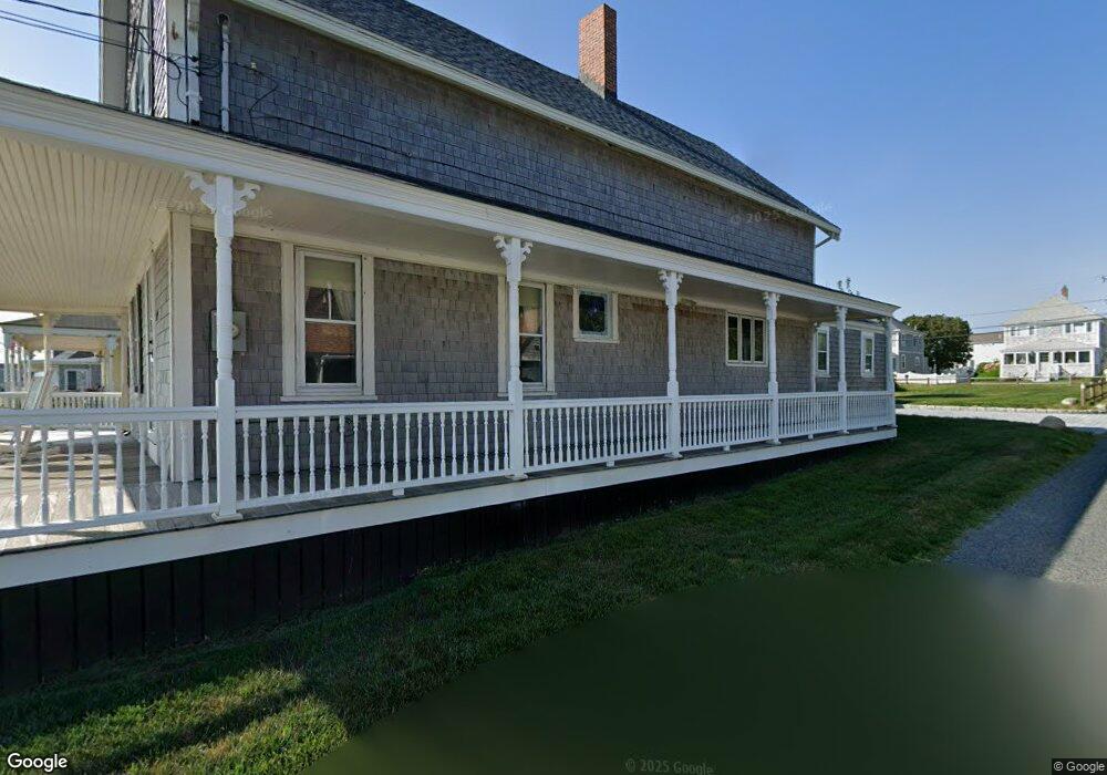
399 Ocean St Marshfield, MA 02050
Ocean Bluff-Brant Rock NeighborhoodEstimated Value: $1,070,000 - $1,266,000
5
Beds
2
Baths
1,906
Sq Ft
$608/Sq Ft
Est. Value
About This Home
This home is located at 399 Ocean St, Marshfield, MA 02050 and is currently estimated at $1,158,870, approximately $608 per square foot. 399 Ocean St is a home with nearby schools including Governor Edward Winslow School, Furnace Brook Middle School, and Marshfield High School.
Ownership History
Date
Name
Owned For
Owner Type
Purchase Details
Closed on
Jul 22, 2025
Sold by
Giroux Ft and Giroux
Bought by
Robert F Giroux Irt and Giroux
Current Estimated Value
Purchase Details
Closed on
Dec 7, 2018
Sold by
Giroux Barbara A
Bought by
Giroux Ft and Giroux
Purchase Details
Closed on
May 22, 2003
Sold by
Giroux Robert F and Giroux Barbara A
Bought by
Giroux Barbara A
Create a Home Valuation Report for This Property
The Home Valuation Report is an in-depth analysis detailing your home's value as well as a comparison with similar homes in the area
Home Values in the Area
Average Home Value in this Area
Purchase History
| Date | Buyer | Sale Price | Title Company |
|---|---|---|---|
| Robert F Giroux Irt | -- | -- | |
| Robert F Giroux Irt | -- | -- | |
| Giroux Ft | -- | -- | |
| Giroux Ft | -- | -- | |
| Giroux Barbara A | -- | -- | |
| Giroux Barbara A | -- | -- |
Source: Public Records
Tax History Compared to Growth
Tax History
| Year | Tax Paid | Tax Assessment Tax Assessment Total Assessment is a certain percentage of the fair market value that is determined by local assessors to be the total taxable value of land and additions on the property. | Land | Improvement |
|---|---|---|---|---|
| 2025 | $10,497 | $1,060,300 | $633,200 | $427,100 |
| 2024 | $9,628 | $926,700 | $557,800 | $368,900 |
| 2023 | $7,880 | $793,700 | $482,400 | $311,300 |
| 2022 | $7,880 | $608,500 | $354,300 | $254,200 |
| 2021 | $7,884 | $597,700 | $354,300 | $243,400 |
| 2020 | $7,522 | $564,300 | $331,700 | $232,600 |
| 2019 | $7,404 | $553,400 | $331,700 | $221,700 |
| 2018 | $7,399 | $553,400 | $331,700 | $221,700 |
| 2017 | $7,418 | $540,700 | $331,700 | $209,000 |
| 2016 | $7,384 | $532,000 | $331,700 | $200,300 |
| 2015 | $7,872 | $592,300 | $392,000 | $200,300 |
| 2014 | $7,704 | $579,700 | $392,000 | $187,700 |
Source: Public Records
Map
Nearby Homes
- 395 Ocean St
- 405 Ocean St
- 90 Ashburton Ave
- 389 Ocean St Unit 2
- 411 Ocean St
- 11 John Alden St
- 385 Ocean St
- 14 Puritan St
- 106 Ashburton Ave
- 419 Ocean St
- 99 Ashburton Ave
- 95 Ashburton Ave
- 89 Ashburton Ave
- 103 Ashburton Ave
- 379 Ocean St
- 379 Ocean St Unit 1
- 379 Ocean St Unit 379
- 83 Ashburton Ave
- 110 Ashburton Ave
- 421 Ocean St