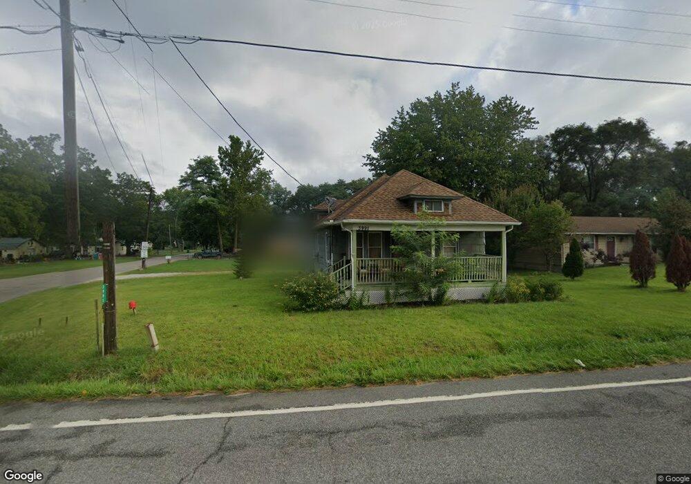
3991 Highway 20 La Porte, IN 46350
Estimated Value: $157,718 - $249,000
3
Beds
1
Bath
1,130
Sq Ft
$180/Sq Ft
Est. Value
About This Home
This home is located at 3991 Highway 20, La Porte, IN 46350 and is currently estimated at $202,930, approximately $179 per square foot. 3991 Highway 20 is a home located in LaPorte County with nearby schools including Springfield Elementary School, Martin T. Krueger Middle School, and Michigan City High School.
Ownership History
Date
Name
Owned For
Owner Type
Purchase Details
Closed on
Nov 30, 2018
Sold by
Pace Cirila M
Bought by
Peterson Wayne R
Current Estimated Value
Home Financials for this Owner
Home Financials are based on the most recent Mortgage that was taken out on this home.
Original Mortgage
$62,000
Outstanding Balance
$54,623
Interest Rate
4.8%
Mortgage Type
VA
Estimated Equity
$148,307
Purchase Details
Closed on
Jul 2, 2009
Sold by
Delco Richard W
Bought by
Pace Dale R and Pace Cirila M
Purchase Details
Closed on
May 27, 2008
Sold by
Delco Richard and Delco Rita
Bought by
Delco Richard W and Richard W Delco Trust
Create a Home Valuation Report for This Property
The Home Valuation Report is an in-depth analysis detailing your home's value as well as a comparison with similar homes in the area
Home Values in the Area
Average Home Value in this Area
Purchase History
| Date | Buyer | Sale Price | Title Company |
|---|---|---|---|
| Peterson Wayne R | -- | None Available | |
| Pace Dale R | -- | Metropolitan Title | |
| Delco Richard W | -- | None Available |
Source: Public Records
Mortgage History
| Date | Status | Borrower | Loan Amount |
|---|---|---|---|
| Open | Peterson Wayne R | $62,000 |
Source: Public Records
Tax History Compared to Growth
Tax History
| Year | Tax Paid | Tax Assessment Tax Assessment Total Assessment is a certain percentage of the fair market value that is determined by local assessors to be the total taxable value of land and additions on the property. | Land | Improvement |
|---|---|---|---|---|
| 2024 | $72 | $82,900 | $21,500 | $61,400 |
| 2023 | $59 | $82,900 | $21,500 | $61,400 |
| 2022 | $59 | $82,400 | $21,500 | $60,900 |
| 2021 | $72 | $77,400 | $21,500 | $55,900 |
| 2020 | $72 | $77,400 | $21,500 | $55,900 |
| 2019 | $1,023 | $76,600 | $17,900 | $58,700 |
| 2018 | $48 | $58,400 | $17,900 | $40,500 |
| 2017 | $1,071 | $54,200 | $17,900 | $36,300 |
| 2016 | $954 | $52,600 | $14,300 | $38,300 |
| 2014 | $957 | $48,900 | $14,300 | $34,600 |
Source: Public Records
Map
Nearby Homes
- 0 W Us Hwy 20
- 5034 N 400 W
- 00 Pawnee Trail
- 000 Pawnee Trail
- 0 Nicomus Path
- 4852 W Us Highway 20
- N 450 W
- 5143 U S 20
- 5188 W Laxita Dr
- 6862 NE Suburban Dr
- 4291 U S 35
- 3959 N 400 W
- 7335 N 300 W
- Lot 88 Meritage Trail
- Lot 5 Malaga Dr W
- Lot 77,78,79 W Concord Dr
- 5611 W Vintage Hills Trail
- 4079 W Schultz Rd
- V/L N 600 W
- 3811 N Claret Trail
- 3991 W Us Highway 20
- 3991 U S 20
- 3991 W Highway 20
- 3981 W Us Highway 20
- 3981 W Us Highway 20
- 3961 U S 20
- 3961 Highway 20
- 5797 N 400 W
- 3961 W Us Highway 20
- 5796 N 400 W
- 5622 N 400 W
- 5813 N 400 W
- 5802 N 400 W
- 5611 N 400 W
- 3923 U S 20
- 3923 W Us Highway 20
- 4071 W Us Highway 20
- 3924 W Us Highway 20
- 3924 U S 20
- 5833 N 400 W