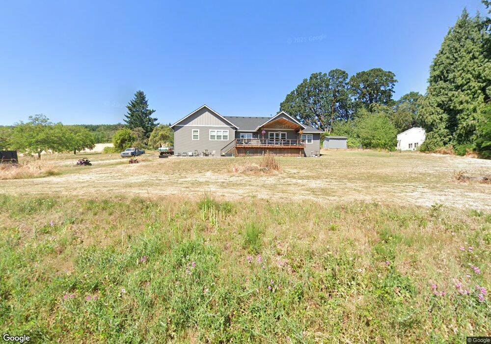
3991 NW Thatcher Rd Forest Grove, OR 97116
Estimated Value: $731,000 - $868,370
3
Beds
3
Baths
2,491
Sq Ft
$321/Sq Ft
Est. Value
About This Home
This home is located at 3991 NW Thatcher Rd, Forest Grove, OR 97116 and is currently estimated at $799,685, approximately $321 per square foot. 3991 NW Thatcher Rd is a home with nearby schools including Harvey Clarke Elementary School, Tom McCall Upper Elementary School, and Neil Armstrong Middle School.
Ownership History
Date
Name
Owned For
Owner Type
Purchase Details
Closed on
Dec 12, 2020
Sold by
Brown Warren B and Brown Carol H
Bought by
Rue Jace T and Rue Hailee Blake
Current Estimated Value
Home Financials for this Owner
Home Financials are based on the most recent Mortgage that was taken out on this home.
Original Mortgage
$445,450
Outstanding Balance
$397,859
Interest Rate
2.8%
Mortgage Type
Construction
Estimated Equity
$401,826
Purchase Details
Closed on
Nov 23, 2011
Sold by
Liv Tasker Susan M
Bought by
Brown Warren B and Brown Carol M
Create a Home Valuation Report for This Property
The Home Valuation Report is an in-depth analysis detailing your home's value as well as a comparison with similar homes in the area
Home Values in the Area
Average Home Value in this Area
Purchase History
| Date | Buyer | Sale Price | Title Company |
|---|---|---|---|
| Rue Jace T | $160,000 | First American | |
| Brown Warren B | -- | None Available |
Source: Public Records
Mortgage History
| Date | Status | Borrower | Loan Amount |
|---|---|---|---|
| Open | Rue Jace T | $445,450 |
Source: Public Records
Tax History Compared to Growth
Tax History
| Year | Tax Paid | Tax Assessment Tax Assessment Total Assessment is a certain percentage of the fair market value that is determined by local assessors to be the total taxable value of land and additions on the property. | Land | Improvement |
|---|---|---|---|---|
| 2026 | $5,717 | $379,680 | -- | -- |
| 2025 | $5,717 | $368,630 | -- | -- |
| 2024 | $5,509 | $357,900 | -- | -- |
| 2023 | $5,509 | $216,690 | $0 | $0 |
| 2022 | $2,985 | $216,690 | $0 | $0 |
| 2021 | $92 | $6,370 | $0 | $0 |
| 2020 | $92 | $6,190 | $0 | $0 |
| 2019 | $90 | $6,010 | $0 | $0 |
| 2018 | $88 | $5,840 | $0 | $0 |
| 2017 | $85 | $5,670 | $0 | $0 |
| 2016 | $82 | $5,510 | $0 | $0 |
Source: Public Records
Map
Nearby Homes
- 3934 Coho Cir
- 45585 NW David Hill Rd
- 44725 NW David Hill Rd
- 0 David Hill Unit 20160858
- 1138 37th Ave
- 45157 NW David Hill Rd
- 3728 Huntsman Way
- 0 Ns Unit 279696115
- 3651 Tiana St
- 724 Glade Ave
- 3403 Glade Ave
- 871 Butte Dr
- 895 Butte Dr
- 873 Butte Dr
- 2117 36th Ave Unit Lot 64
- 2133 36th Ave Unit Lot 62
- 875 Butte Dr
- 2120 36th Ave
- 2150 36th Ave
- 2130 36th Ave
- 4135 NW Thatcher Rd
- 4012 NW Thatcher Rd
- 4177 NW Thatcher Rd
- 4263 NW Thatcher Rd
- 3690 NW Thatcher Rd
- 3805 NW Thatcher Rd
- 4246 NW Thatcher Rd
- 4143 NW Thatcher Rd
- 3749 NW Thatcher Rd
- 4295 NW Thatcher Rd
- 3575 NW Thatcher Rd
- 4352 NW Thatcher Rd
- 3406 NW Thatcher Rd
- 3934 Coho Cir Unit I9
- 3934 Coho Cir Unit 19
- 3934 Coho Cir Unit A/1
- 3926 Coho Cir Unit 8/H
- 3344 NW Thatcher Rd
- 3918 Coho Cir
- 3900 Coho Cir