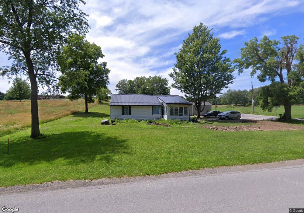
3994 Fail Rd La Porte, IN 46350
Estimated Value: $259,000 - $323,000
3
Beds
2
Baths
1,196
Sq Ft
$244/Sq Ft
Est. Value
About This Home
This home is located at 3994 Fail Rd, La Porte, IN 46350 and is currently estimated at $291,413, approximately $243 per square foot. 3994 Fail Rd is a home located in LaPorte County with nearby schools including New Prairie High School and Sacred Heart Apostolic School.
Ownership History
Date
Name
Owned For
Owner Type
Purchase Details
Closed on
Feb 14, 2024
Sold by
Mayes David L
Bought by
Lamica Darin William
Current Estimated Value
Home Financials for this Owner
Home Financials are based on the most recent Mortgage that was taken out on this home.
Original Mortgage
$274,437
Outstanding Balance
$268,784
Interest Rate
6.62%
Mortgage Type
FHA
Estimated Equity
$22,629
Purchase Details
Closed on
Jun 26, 2023
Sold by
Womack Robert F
Bought by
Womack Brianna
Home Financials for this Owner
Home Financials are based on the most recent Mortgage that was taken out on this home.
Original Mortgage
$157,600
Interest Rate
6.79%
Mortgage Type
New Conventional
Purchase Details
Closed on
Mar 31, 2023
Sold by
Pine Valley One Real Estate Llc
Bought by
Petri Harold and Petri Amy
Purchase Details
Closed on
Sep 15, 2014
Sold by
Womack Gwendolen J
Bought by
Womack Robert F
Create a Home Valuation Report for This Property
The Home Valuation Report is an in-depth analysis detailing your home's value as well as a comparison with similar homes in the area
Purchase History
| Date | Buyer | Sale Price | Title Company |
|---|---|---|---|
| Lamica Darin William | -- | None Listed On Document | |
| Womack Brianna | $197,000 | None Listed On Document | |
| Petri Harold | -- | None Listed On Document | |
| Womack Robert F | -- | None Available |
Source: Public Records
Mortgage History
| Date | Status | Borrower | Loan Amount |
|---|---|---|---|
| Open | Lamica Darin William | $274,437 | |
| Previous Owner | Womack Brianna | $157,600 |
Source: Public Records
Tax History
| Year | Tax Paid | Tax Assessment Tax Assessment Total Assessment is a certain percentage of the fair market value that is determined by local assessors to be the total taxable value of land and additions on the property. | Land | Improvement |
|---|---|---|---|---|
| 2025 | $1,497 | $160,200 | $33,600 | $126,600 |
| 2024 | $2,585 | $156,500 | $33,600 | $122,900 |
| 2023 | $2,506 | $116,400 | $33,600 | $82,800 |
| 2022 | $1,035 | $119,900 | $33,600 | $86,300 |
| 2021 | $1,045 | $114,200 | $33,600 | $80,600 |
| 2020 | $1,034 | $114,200 | $33,600 | $80,600 |
| 2019 | $954 | $103,600 | $33,600 | $70,000 |
| 2018 | $890 | $103,600 | $33,600 | $70,000 |
| 2017 | $765 | $95,200 | $28,000 | $67,200 |
| 2016 | $844 | $96,400 | $28,000 | $68,400 |
| 2014 | $1,700 | $84,600 | $22,400 | $62,200 |
Source: Public Records
Map
Nearby Homes
- 842 E Sportsman Ln
- 4755 N Range Rd
- Lots 41-44 Campbell
- 2027 N Coachlight Dr
- 1083 Indiana 2 Unit 18
- 1083 Indiana 2 Unit 405
- 1083 Indiana 2
- 4711 N 100 W
- 3202 N 300 E
- 2248 E State Road 2
- 6864 N Nature Ln
- 6869 N Nature Ln
- 6863 N Nature Ln Unit 3
- 6862 N Nature Ln
- 6863 N Nature Ln
- 6854 N Nature Ln
- 4404 N 350 E
- 2897 N Morning Glory Ave
- 344 E 650 N
- 2945 N Morning Glory Ave Unit 73
Your Personal Tour Guide
Ask me questions while you tour the home.