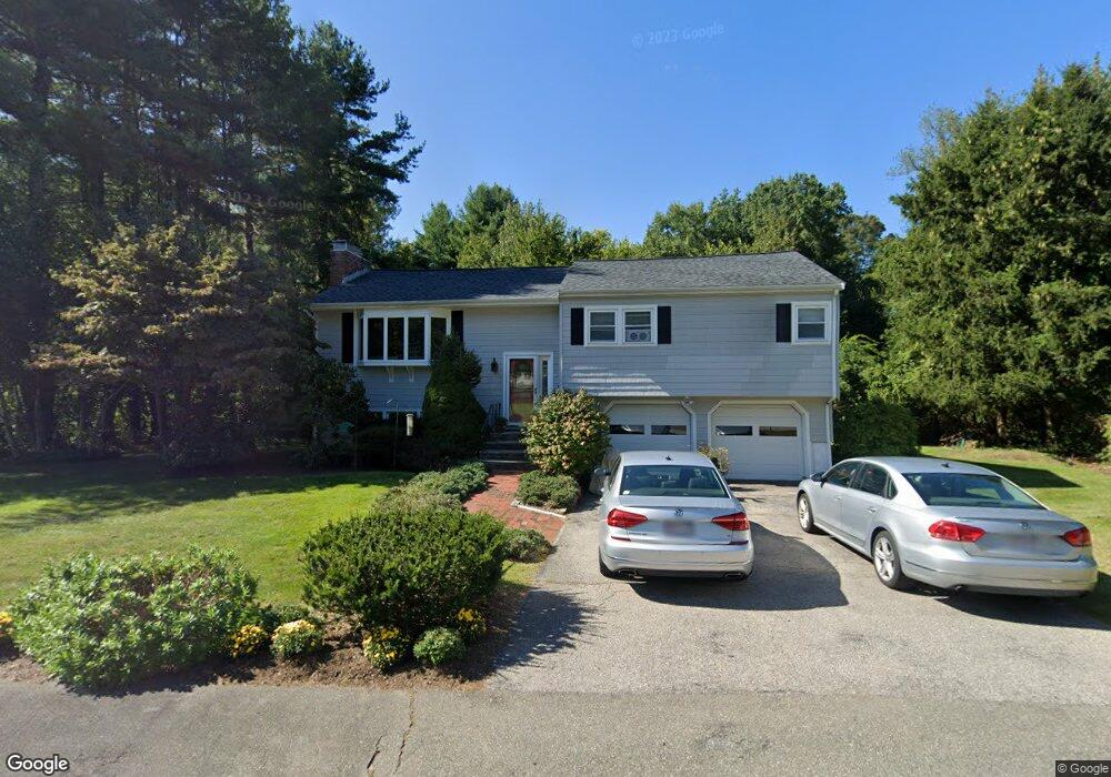
4 Alder Rd Medfield, MA 02052
Estimated Value: $772,000 - $852,000
3
Beds
3
Baths
1,782
Sq Ft
$458/Sq Ft
Est. Value
About This Home
This home is located at 4 Alder Rd, Medfield, MA 02052 and is currently estimated at $815,934, approximately $457 per square foot. 4 Alder Rd is a home located in Norfolk County with nearby schools including Ralph Wheelock School, Memorial School, and Dale Street School.
Ownership History
Date
Name
Owned For
Owner Type
Purchase Details
Closed on
Jan 28, 2020
Sold by
Scollard Garrett W and Scollard Teri M
Bought by
Scollard Ret and Scollard
Current Estimated Value
Purchase Details
Closed on
Feb 23, 1998
Sold by
Oconnor Carole A
Bought by
Scollard Gary W and Scollard Geri M
Home Financials for this Owner
Home Financials are based on the most recent Mortgage that was taken out on this home.
Original Mortgage
$209,250
Interest Rate
6.9%
Mortgage Type
Purchase Money Mortgage
Purchase Details
Closed on
Aug 14, 1987
Sold by
Furkey Peter R
Bought by
O'Connor Carole A
Home Financials for this Owner
Home Financials are based on the most recent Mortgage that was taken out on this home.
Original Mortgage
$50,000
Interest Rate
10.4%
Mortgage Type
Purchase Money Mortgage
Create a Home Valuation Report for This Property
The Home Valuation Report is an in-depth analysis detailing your home's value as well as a comparison with similar homes in the area
Home Values in the Area
Average Home Value in this Area
Purchase History
| Date | Buyer | Sale Price | Title Company |
|---|---|---|---|
| Scollard Ret | -- | None Available | |
| Scollard Ret | -- | None Available | |
| Scollard Gary W | $232,500 | -- | |
| Scollard Gary W | $232,500 | -- | |
| O'Connor Carole A | $187,000 | -- |
Source: Public Records
Mortgage History
| Date | Status | Borrower | Loan Amount |
|---|---|---|---|
| Previous Owner | Scollard Gary W | $209,250 | |
| Previous Owner | O'Connor Carole A | $50,000 | |
| Previous Owner | O'Connor Carole A | $60,000 | |
| Previous Owner | O'Connor Carole A | $50,000 |
Source: Public Records
Tax History
| Year | Tax Paid | Tax Assessment Tax Assessment Total Assessment is a certain percentage of the fair market value that is determined by local assessors to be the total taxable value of land and additions on the property. | Land | Improvement |
|---|---|---|---|---|
| 2025 | $8,854 | $641,600 | $403,900 | $237,700 |
| 2024 | $8,636 | $589,900 | $368,800 | $221,100 |
| 2023 | $8,510 | $551,500 | $351,300 | $200,200 |
| 2022 | $8,208 | $471,200 | $333,700 | $137,500 |
| 2021 | $8,079 | $454,900 | $331,900 | $123,000 |
| 2020 | $8,006 | $449,000 | $330,200 | $118,800 |
| 2019 | $7,693 | $430,500 | $316,100 | $114,400 |
| 2018 | $6,829 | $401,000 | $294,400 | $106,600 |
| 2017 | $6,606 | $391,100 | $284,500 | $106,600 |
| 2016 | $6,492 | $387,600 | $281,000 | $106,600 |
| 2015 | $5,941 | $370,400 | $270,100 | $100,300 |
| 2014 | $6,071 | $376,600 | $276,300 | $100,300 |
Source: Public Records
Map
Nearby Homes
Your Personal Tour Guide
Ask me questions while you tour the home.