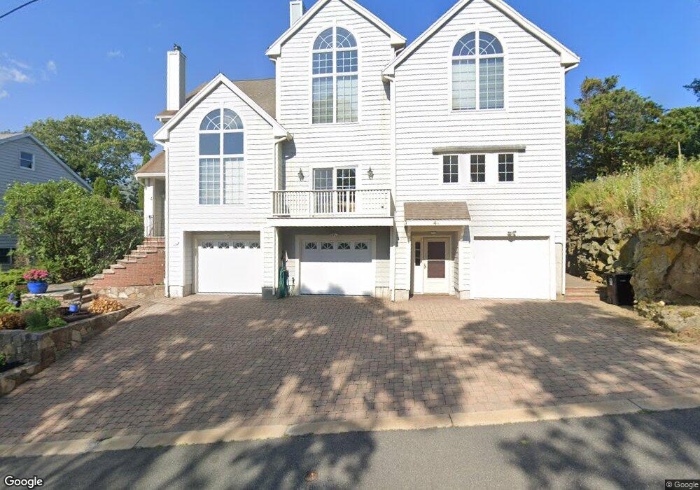
4 Alvin Rd Swampscott, MA 01907
Estimated Value: $980,000 - $1,167,855
4
Beds
2
Baths
3,726
Sq Ft
$295/Sq Ft
Est. Value
About This Home
This home is located at 4 Alvin Rd, Swampscott, MA 01907 and is currently estimated at $1,099,464, approximately $295 per square foot. 4 Alvin Rd is a home located in Essex County with nearby schools including Swampscott Middle School and Swampscott High School.
Ownership History
Date
Name
Owned For
Owner Type
Purchase Details
Closed on
May 14, 2007
Sold by
Dilisio Antoinette D and Dilisio Vincent R
Bought by
Farrell Lisa Marie
Current Estimated Value
Purchase Details
Closed on
Jun 3, 1992
Sold by
Dilisio Vincent and Dilisio Albert
Bought by
P & M Rt
Create a Home Valuation Report for This Property
The Home Valuation Report is an in-depth analysis detailing your home's value as well as a comparison with similar homes in the area
Home Values in the Area
Average Home Value in this Area
Purchase History
| Date | Buyer | Sale Price | Title Company |
|---|---|---|---|
| Farrell Lisa Marie | -- | -- | |
| Farrell Lisa Marie | -- | -- | |
| P & M Rt | $62,500 | -- | |
| P & M Rt | $62,500 | -- |
Source: Public Records
Tax History Compared to Growth
Tax History
| Year | Tax Paid | Tax Assessment Tax Assessment Total Assessment is a certain percentage of the fair market value that is determined by local assessors to be the total taxable value of land and additions on the property. | Land | Improvement |
|---|---|---|---|---|
| 2025 | $12,391 | $1,080,300 | $255,200 | $825,100 |
| 2024 | $12,071 | $1,050,600 | $243,100 | $807,500 |
| 2023 | $11,652 | $992,500 | $225,000 | $767,500 |
| 2022 | $11,965 | $932,600 | $198,000 | $734,600 |
| 2021 | $11,596 | $840,300 | $171,000 | $669,300 |
| 2020 | $10,330 | $722,400 | $162,000 | $560,400 |
| 2019 | $10,707 | $704,400 | $144,000 | $560,400 |
| 2018 | $10,922 | $682,600 | $144,000 | $538,600 |
| 2017 | $10,957 | $627,900 | $117,000 | $510,900 |
| 2016 | $10,343 | $596,800 | $108,000 | $488,800 |
| 2015 | $10,235 | $596,800 | $108,000 | $488,800 |
| 2014 | $10,156 | $543,100 | $90,000 | $453,100 |
Source: Public Records
Map
Nearby Homes
- 2 Gracie Ln Unit 4
- 10-12 Fairview Ave
- 445 Essex St Unit 304
- 8 Ryan Place
- 5 Summit View Dr
- 51 Barnstable St
- 306 Paradise Rd
- 309 Paradise Rd
- 27 Weatherly Dr Unit 27
- 76 Stetson Ave
- 1004 Paradise Rd Unit PHJ
- 86 Freedom Hollow
- 1006 Paradise Rd Unit 3R
- 106 Norfolk Ave
- 6 Loring Hills Ave Unit D3
- 100 Burpee Rd
- 98 Paradise Rd
- 71 Walnut Rd
- 80 Norfolk Ave Unit 1
- 3 Cedarcrest Rd
- 2 Alvin Rd Unit B
- 2 Alvin Rd Unit A
- 17 Ryan Place
- 21 Ryan Place
- 15 Ryan Place
- 13 Ryan Place
- 13 Ryan Place Unit 13
- 13 Ryan Place Unit 1
- 6 Alvin Rd Unit 2
- 8 Alvin Rd
- 1 Alvin Rd
- 6 Alvin Rd
- 6 Alvin Rd Unit 6
- 6 Alvin Rd Unit 1
- 413 Essex St
- 417 Essex St
- 35 Alvin Rd
- 421 Essex St
- 6 Gracie Ln Unit 6
- 8 Gracie Ln Unit 8