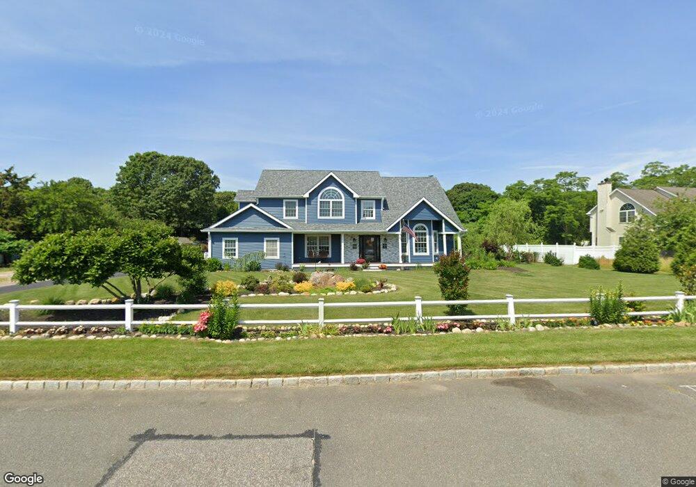
4 Anthony Dr Rocky Point, NY 11778
Estimated Value: $788,156 - $1,045,000
5
Beds
3
Baths
3,500
Sq Ft
$260/Sq Ft
Est. Value
About This Home
This home is located at 4 Anthony Dr, Rocky Point, NY 11778 and is currently estimated at $911,289, approximately $260 per square foot. 4 Anthony Dr is a home located in Suffolk County with nearby schools including Joseph A Edgar Imtermediate School, Frank J. Carasiti Elementary School, and Rocky Point Middle School.
Ownership History
Date
Name
Owned For
Owner Type
Purchase Details
Closed on
Jun 18, 2018
Sold by
Pence David and Pence Denise
Bought by
Martino Robert and Martino Melissa M
Current Estimated Value
Home Financials for this Owner
Home Financials are based on the most recent Mortgage that was taken out on this home.
Original Mortgage
$443,700
Interest Rate
4.6%
Mortgage Type
New Conventional
Purchase Details
Closed on
Dec 10, 2015
Sold by
Us Bank National Association 2003 17
Bought by
Pence David and Pence Denise
Purchase Details
Closed on
Feb 18, 2015
Sold by
Besunder Esq Harvey Bruce and Wind Richard J
Bought by
U S Bank National Association
Purchase Details
Closed on
Apr 11, 2003
Sold by
Prestan Homes Inc
Bought by
Wind Richard J and Wind Theresa A
Home Financials for this Owner
Home Financials are based on the most recent Mortgage that was taken out on this home.
Original Mortgage
$348,000
Interest Rate
5.64%
Mortgage Type
Purchase Money Mortgage
Create a Home Valuation Report for This Property
The Home Valuation Report is an in-depth analysis detailing your home's value as well as a comparison with similar homes in the area
Home Values in the Area
Average Home Value in this Area
Purchase History
| Date | Buyer | Sale Price | Title Company |
|---|---|---|---|
| Martino Robert | -- | -- | |
| Pence David | $275,000 | None Available | |
| U S Bank National Association | $428,706 | None Available | |
| Wind Richard J | $435,000 | -- |
Source: Public Records
Mortgage History
| Date | Status | Borrower | Loan Amount |
|---|---|---|---|
| Previous Owner | Martino Robert | $443,700 | |
| Previous Owner | Wind Richard J | $348,000 | |
| Closed | U S Bank National Association | $0 |
Source: Public Records
Tax History Compared to Growth
Tax History
| Year | Tax Paid | Tax Assessment Tax Assessment Total Assessment is a certain percentage of the fair market value that is determined by local assessors to be the total taxable value of land and additions on the property. | Land | Improvement |
|---|---|---|---|---|
| 2024 | $18,022 | $3,970 | $485 | $3,485 |
| 2023 | $18,022 | $3,970 | $485 | $3,485 |
| 2022 | $16,393 | $3,970 | $485 | $3,485 |
| 2021 | $16,393 | $3,970 | $485 | $3,485 |
| 2020 | $16,584 | $3,970 | $485 | $3,485 |
| 2019 | $16,584 | $0 | $0 | $0 |
| 2018 | $15,804 | $3,970 | $485 | $3,485 |
| 2017 | $15,804 | $3,970 | $485 | $3,485 |
| 2016 | $15,460 | $3,970 | $485 | $3,485 |
| 2015 | -- | $3,970 | $485 | $3,485 |
| 2014 | -- | $3,970 | $485 | $3,485 |
Source: Public Records
Map
Nearby Homes
- Land Anthony Dr
- 6 Anthony Dr
- 3 Anthony Dr
- 5 Anthony Dr
- 1 Anthony Dr
- 10 Anthony Dr
- 780 Route 25A
- 20 Anthony Dr
- 21 N Country Rd
- 4 Dora Rd Unit 4
- 781 Route 25A Unit 1
- 781 Route 25A
- 6 Dora Rd Unit 6
- 10 Van Buren St
- 759 Route 25A
- 5 Harrison St
- 799 Route 25A
- 799 Route 25A
- 799 Route 25A Unit A
- 799 Route 25A Unit B