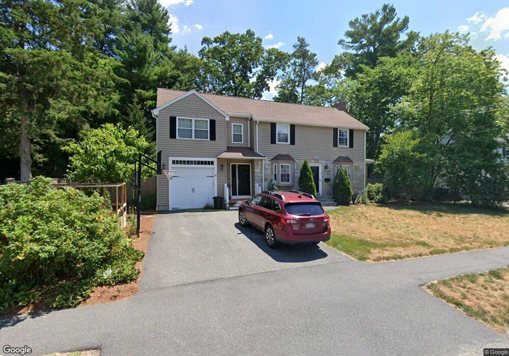
4 Barnesdale Rd Natick, MA 01760
Estimated Value: $1,317,000 - $1,412,000
5
Beds
5
Baths
2,860
Sq Ft
$481/Sq Ft
Est. Value
About This Home
This home is located at 4 Barnesdale Rd, Natick, MA 01760 and is currently estimated at $1,376,343, approximately $481 per square foot. 4 Barnesdale Rd is a home located in Middlesex County with nearby schools including Natick High School, Brown Elementary School, and J F Kennedy Middle School.
Ownership History
Date
Name
Owned For
Owner Type
Purchase Details
Closed on
Jul 19, 2000
Sold by
4 Barnesdale Rd Rt
Bought by
Sullivan Peter D and Sullivan Barbara F
Current Estimated Value
Create a Home Valuation Report for This Property
The Home Valuation Report is an in-depth analysis detailing your home's value as well as a comparison with similar homes in the area
Home Values in the Area
Average Home Value in this Area
Purchase History
| Date | Buyer | Sale Price | Title Company |
|---|---|---|---|
| Sullivan Peter D | $249,900 | -- |
Source: Public Records
Mortgage History
| Date | Status | Borrower | Loan Amount |
|---|---|---|---|
| Open | Sullivan Peter D | $465,250 | |
| Closed | Sullivan Peter D | $345,000 | |
| Closed | Sullivan Peter D | $30,000 | |
| Closed | Sullivan Peter D | $203,000 |
Source: Public Records
Tax History Compared to Growth
Tax History
| Year | Tax Paid | Tax Assessment Tax Assessment Total Assessment is a certain percentage of the fair market value that is determined by local assessors to be the total taxable value of land and additions on the property. | Land | Improvement |
|---|---|---|---|---|
| 2025 | $13,491 | $1,128,000 | $478,700 | $649,300 |
| 2024 | $12,931 | $1,054,700 | $453,500 | $601,200 |
| 2023 | $12,440 | $984,200 | $423,000 | $561,200 |
| 2022 | $12,062 | $904,200 | $382,400 | $521,800 |
| 2021 | $11,589 | $851,500 | $362,300 | $489,200 |
| 2020 | $11,383 | $836,400 | $347,200 | $489,200 |
| 2019 | $10,631 | $836,400 | $347,200 | $489,200 |
| 2018 | $10,882 | $833,900 | $301,900 | $532,000 |
| 2017 | $10,521 | $779,900 | $257,400 | $522,500 |
| 2016 | $10,228 | $753,700 | $236,400 | $517,300 |
| 2015 | $9,747 | $705,300 | $236,400 | $468,900 |
Source: Public Records
Map
Nearby Homes
- 233 Speen St
- 8 Hartford St
- 21 Kelsey Rd
- 40 Nouvelle Way Unit 441
- 10 Nouvelle Way Unit 923
- 40 Nouvelle Way Unit 749
- 10 Nouvelle Way Unit 803
- 38 Ranger Rd
- 36 Porter Rd
- 2 Lodge Rd
- 55 Fisher St
- 34 Fisher St
- 293 Bacon St Unit B
- 18 2nd St
- 5 Crest Rd
- 39 Evergreen Rd
- 7 Village Way Unit 4
- 91 Speen St
- 32 Silver Hill Ln Unit 1
- 143 Howe St
- 6 Barnesdale Rd
- 24 Nottingham Dr
- 22 Nottingham Dr
- 17 Sherwood Rd
- 8 Barnesdale Rd
- 15 Sherwood Rd
- 3 Barnesdale Rd
- 20 Nottingham Dr
- 1 Barnesdale Rd
- 7 Barnesdale Rd
- 13 Sherwood Rd
- 19 Sherwood Rd
- 21 Nottingham Dr
- 10 Barnesdale Rd
- 19 Nottingham Dr
- 44 Hartford St
- 18 Nottingham Dr
- 3 Greenwood Rd
- 48 Hartford St
- 42 Hartford St