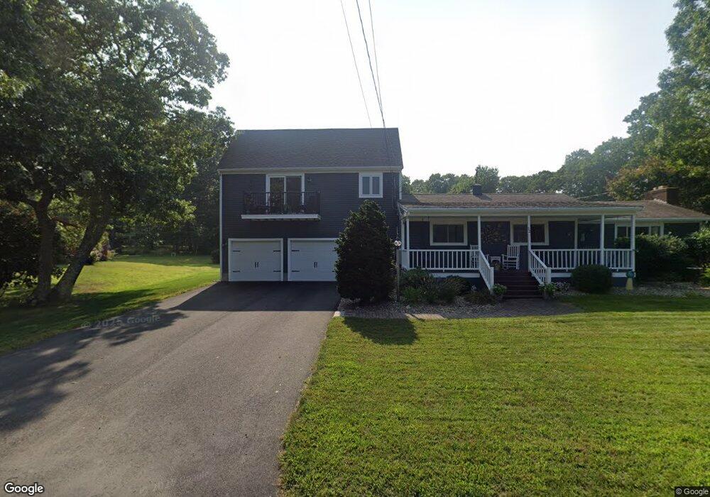
4 Bowler Rd Wareham, MA 02571
Estimated Value: $524,000 - $669,000
2
Beds
3
Baths
1,346
Sq Ft
$437/Sq Ft
Est. Value
About This Home
This home is located at 4 Bowler Rd, Wareham, MA 02571 and is currently estimated at $587,632, approximately $436 per square foot. 4 Bowler Rd is a home located in Plymouth County.
Ownership History
Date
Name
Owned For
Owner Type
Purchase Details
Closed on
Nov 6, 2019
Sold by
Santoro Ret 2014 and Santoro
Bought by
Santoro Kristen and Hubbard Jeffrey
Current Estimated Value
Home Financials for this Owner
Home Financials are based on the most recent Mortgage that was taken out on this home.
Original Mortgage
$250,000
Outstanding Balance
$218,981
Interest Rate
3.6%
Mortgage Type
New Conventional
Estimated Equity
$368,651
Purchase Details
Closed on
Dec 1, 2014
Sold by
Santoro Viola L and Santoro John
Bought by
Santoro Ret and Santoro
Purchase Details
Closed on
Aug 31, 1965
Bought by
Santoro John
Create a Home Valuation Report for This Property
The Home Valuation Report is an in-depth analysis detailing your home's value as well as a comparison with similar homes in the area
Purchase History
| Date | Buyer | Sale Price | Title Company |
|---|---|---|---|
| Santoro Kristen | $340,000 | -- | |
| Santoro Kristen | $340,000 | -- | |
| Santoro Ret | -- | -- | |
| Santoro Ret | -- | -- | |
| Santoro Ret | -- | -- | |
| Santoro John | -- | -- |
Source: Public Records
Mortgage History
| Date | Status | Borrower | Loan Amount |
|---|---|---|---|
| Open | Santoro Kristen | $250,000 | |
| Closed | Santoro Kristen | $250,000 |
Source: Public Records
Tax History
| Year | Tax Paid | Tax Assessment Tax Assessment Total Assessment is a certain percentage of the fair market value that is determined by local assessors to be the total taxable value of land and additions on the property. | Land | Improvement |
|---|---|---|---|---|
| 2025 | $4,676 | $448,800 | $126,700 | $322,100 |
| 2024 | $4,724 | $420,700 | $99,100 | $321,600 |
| 2023 | $4,224 | $376,600 | $90,100 | $286,500 |
| 2022 | $4,224 | $320,500 | $90,100 | $230,400 |
| 2021 | $4,168 | $309,900 | $90,100 | $219,800 |
| 2020 | $3,877 | $292,400 | $90,100 | $202,300 |
| 2019 | $3,598 | $270,700 | $87,100 | $183,600 |
| 2018 | $3,379 | $247,900 | $87,100 | $160,800 |
| 2017 | $3,193 | $237,400 | $87,100 | $150,300 |
| 2016 | $2,855 | $211,000 | $81,000 | $130,000 |
| 2015 | $2,758 | $211,000 | $81,000 | $130,000 |
| 2014 | $2,779 | $216,300 | $88,300 | $128,000 |
Source: Public Records
Map
Nearby Homes
- 200 Great Neck Rd
- 8 Over Jordan Rd
- 14 Over Jordan Rd
- 65 Great Neck Rd
- 248 Great Neck Rd
- 10 Dowd Ave
- 6 Beacon St Unit 79
- 38 Amos Way
- 10 Beacon St Unit 83
- 26 Highland Ave
- 10 East Blvd
- 10 East Blvd
- 12 Beacon St Unit 84
- 0 Squaw's Path
- 276a Onset Ave
- 3 Carleton St Unit 3
- 32 Carleton St Unit 32
- 35 Locust St
- 35 Locust St
- 22 Bay View Ave
- 12 Little Harbor Rd
- 10 Bowler Rd
- 6 Bowler Rd
- 10 Little Harbor Rd
- 3 Bowler Rd
- 5 Bowler Rd
- 6 Cushman
- 5 Cushman Rd
- 6 Bayberry Rd
- 8 Bayberry Rd
- 14 Little Harbor Rd
- 9 Bowler Rd
- 11 Little Harbor Rd
- 4 Bayberry Rd
- 4 Cushman Rd
- 7 Cushman Rd
- 10 Bayberry Rd
- 16 Little Harbor Rd
- 13 Little Harbor Rd
- 16 Spindrift Ln
Your Personal Tour Guide
Ask me questions while you tour the home.