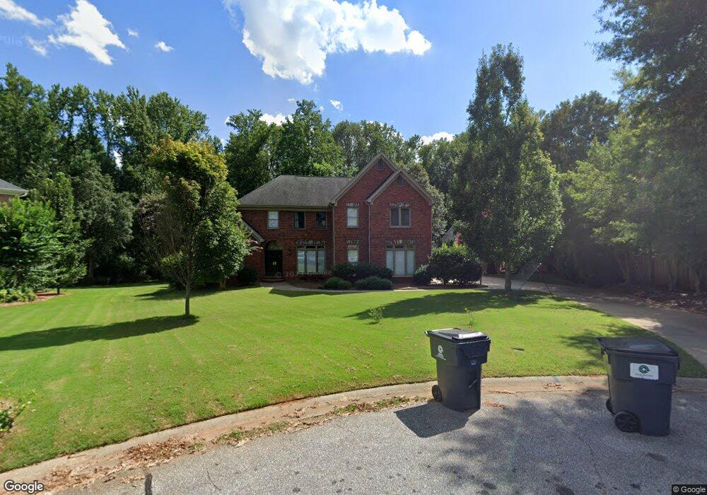
4 Cardiff Ct Simpsonville, SC 29681
Estimated Value: $758,151 - $864,000
4
Beds
6
Baths
3,423
Sq Ft
$236/Sq Ft
Est. Value
About This Home
This home is located at 4 Cardiff Ct, Simpsonville, SC 29681 and is currently estimated at $806,288, approximately $235 per square foot. 4 Cardiff Ct is a home located in Greenville County with nearby schools including Oakview Elementary School, Beck Academy, and J. L. Mann High Academy.
Ownership History
Date
Name
Owned For
Owner Type
Purchase Details
Closed on
May 31, 2005
Sold by
Wolf Anne P
Bought by
Draper Emily J
Current Estimated Value
Home Financials for this Owner
Home Financials are based on the most recent Mortgage that was taken out on this home.
Original Mortgage
$245,000
Outstanding Balance
$127,328
Interest Rate
5.69%
Mortgage Type
New Conventional
Estimated Equity
$678,960
Purchase Details
Closed on
Jun 9, 2004
Sold by
Howard Philip E
Bought by
Wolf Anne P
Create a Home Valuation Report for This Property
The Home Valuation Report is an in-depth analysis detailing your home's value as well as a comparison with similar homes in the area
Home Values in the Area
Average Home Value in this Area
Purchase History
| Date | Buyer | Sale Price | Title Company |
|---|---|---|---|
| Draper Emily J | $382,000 | -- | |
| Wolf Anne P | $355,000 | -- |
Source: Public Records
Mortgage History
| Date | Status | Borrower | Loan Amount |
|---|---|---|---|
| Open | Wolf Anne P | $245,000 | |
| Closed | Wolf Anne P | $117,900 |
Source: Public Records
Tax History Compared to Growth
Tax History
| Year | Tax Paid | Tax Assessment Tax Assessment Total Assessment is a certain percentage of the fair market value that is determined by local assessors to be the total taxable value of land and additions on the property. | Land | Improvement |
|---|---|---|---|---|
| 2024 | $2,792 | $18,920 | $2,760 | $16,160 |
| 2023 | $2,792 | $18,920 | $2,760 | $16,160 |
| 2022 | $2,705 | $18,920 | $2,760 | $16,160 |
| 2021 | $2,688 | $18,920 | $2,760 | $16,160 |
| 2020 | $2,648 | $17,760 | $2,500 | $15,260 |
| 2019 | $2,650 | $17,760 | $2,500 | $15,260 |
| 2018 | $2,804 | $17,760 | $2,500 | $15,260 |
| 2017 | $2,763 | $17,590 | $2,500 | $15,090 |
| 2016 | $2,655 | $439,680 | $62,500 | $377,180 |
| 2015 | $2,646 | $439,680 | $62,500 | $377,180 |
| 2014 | $2,679 | $447,120 | $69,000 | $378,120 |
Source: Public Records
Map
Nearby Homes
- 220 Huddersfield Dr
- 705 Spaulding Farm Rd
- 216 Asheton Lakes Way
- 19 Moray Place
- 6 Gables Way
- 7 Sweetspire Ln
- 9 Sweetspire Ln
- 7 Hitchcock Ln
- 12 Germander Ct
- 17 Ruby Lake Ln
- 127 Riverland Woods Ct
- 4 Hanging Moss Ln
- 8 Wild Thorn Ln
- 25 Willow Oak Ct
- 1302 Moore Rd
- 7 Wild Thorn Ln
- 503 Spaulding Lake Dr
- 1 Big Oak Ct
- 1 Glencove Ct
- 110 Oak Creek Ln
- 6 Cardiff Ct
- 201 Huddersfield Dr
- 203 Huddersfield Dr
- 205 Huddersfield Dr
- 5 Cardiff Ct
- 3 Cardiff Ct
- 105 Huddersfield Dr
- 604 Asheton Way
- 608 Asheton Way
- 606 Asheton Way
- 200 Huddersfield Dr
- 207 Huddersfield Dr
- 204 Huddersfield Dr
- 103 Huddersfield Dr
- 104 Huddersfield Dr
- 209 Huddersfield Dr
- 206 Huddersfield Dr
- 610 Asheton Way
- 602 Asheton Way
- 102 Huddersfield Dr