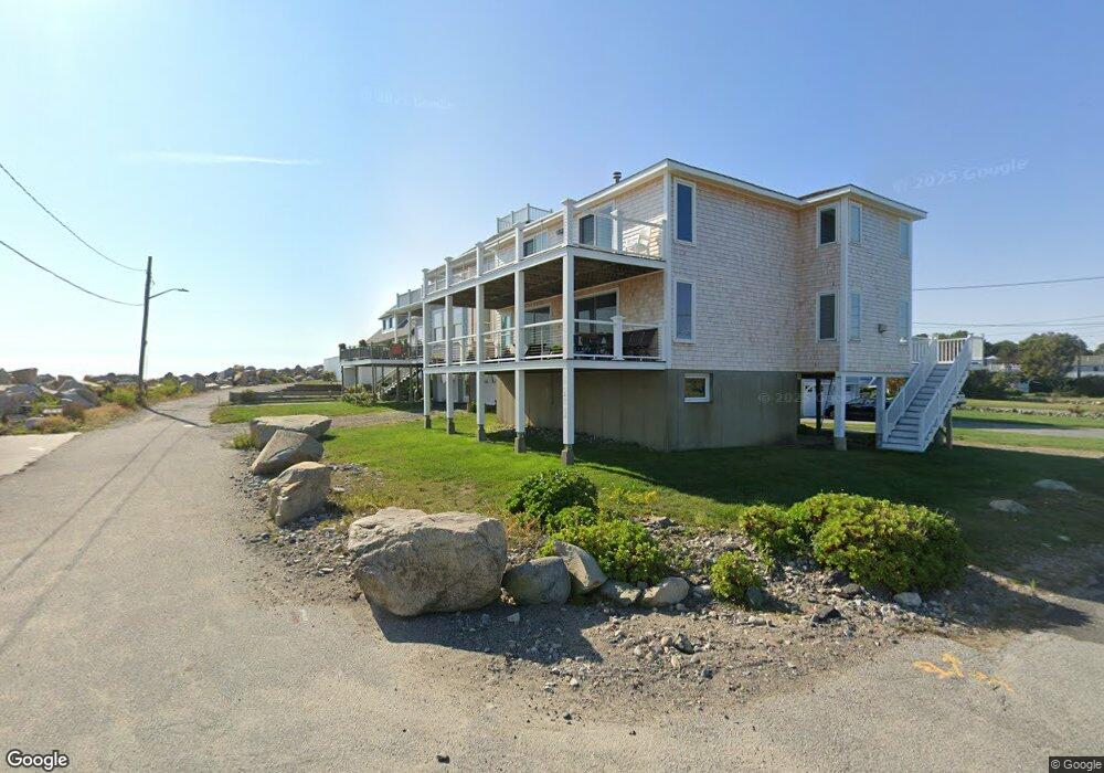
4 Dickens Row Scituate, MA 02066
Estimated Value: $1,718,000 - $1,895,000
4
Beds
3
Baths
2,371
Sq Ft
$755/Sq Ft
Est. Value
About This Home
This home is located at 4 Dickens Row, Scituate, MA 02066 and is currently estimated at $1,790,284, approximately $755 per square foot. 4 Dickens Row is a home located in Plymouth County with nearby schools including Jenkins Elementary School, Lester J. Gates Middle School, and Scituate High School.
Ownership History
Date
Name
Owned For
Owner Type
Purchase Details
Closed on
Feb 1, 2008
Sold by
Sax Eric J and Sax Julia L
Bought by
Sax Tr Eric J and Sax Julia L
Current Estimated Value
Purchase Details
Closed on
Jun 30, 2005
Sold by
Daly Jeffrey S and Daly Ronda M
Bought by
Sax Eric J and Sax Julia L
Purchase Details
Closed on
Sep 13, 2002
Sold by
Dwyer Helen C Est
Bought by
Daly Jeffrey and Daly Ronda M
Purchase Details
Closed on
Jun 30, 1998
Sold by
Beech John E
Bought by
Bartlett Gene
Create a Home Valuation Report for This Property
The Home Valuation Report is an in-depth analysis detailing your home's value as well as a comparison with similar homes in the area
Home Values in the Area
Average Home Value in this Area
Purchase History
| Date | Buyer | Sale Price | Title Company |
|---|---|---|---|
| Sax Tr Eric J | -- | -- | |
| Sax Eric J | $515,000 | -- | |
| Daly Jeffrey | $315,000 | -- | |
| Bartlett Gene | $455,000 | -- |
Source: Public Records
Mortgage History
| Date | Status | Borrower | Loan Amount |
|---|---|---|---|
| Open | Bartlett Gene | $441,000 | |
| Previous Owner | Bartlett Gene | $109,000 |
Source: Public Records
Tax History
| Year | Tax Paid | Tax Assessment Tax Assessment Total Assessment is a certain percentage of the fair market value that is determined by local assessors to be the total taxable value of land and additions on the property. | Land | Improvement |
|---|---|---|---|---|
| 2025 | $14,631 | $1,464,600 | $846,800 | $617,800 |
| 2024 | $14,285 | $1,378,900 | $805,600 | $573,300 |
| 2023 | $13,338 | $1,258,700 | $748,600 | $510,100 |
| 2022 | $13,338 | $1,056,900 | $623,500 | $433,400 |
| 2021 | $7,027 | $966,800 | $593,800 | $373,000 |
| 2020 | $6,697 | $930,900 | $570,900 | $360,000 |
| 2019 | $11,412 | $830,600 | $486,700 | $343,900 |
| 2018 | $11,220 | $804,300 | $484,300 | $320,000 |
| 2017 | $6,181 | $783,700 | $463,700 | $320,000 |
| 2016 | $10,780 | $762,400 | $453,400 | $309,000 |
| 2015 | $9,718 | $741,800 | $432,800 | $309,000 |
Source: Public Records
Map
Nearby Homes
- 55 Crescent Ave
- 59 Greenfield Ln
- 24 Ridge Hill Rd
- 15 Bearce Ln
- 91 Front St Unit 106
- 50 First Parish Rd
- 25 Morton Place
- 23 Sunset Rd
- 46 Tilden Rd
- 34 Ladds Way
- 11 Brookline Rd
- 21 Jenkins Place
- 32 Barker Rd Unit 3
- 14 Old Country Way Unit C
- 14 Old Country Way Unit B
- 19 Ford Place Unit 1
- 19 Ford Place Unit 2
- 38 Lauren Ln
- 86 Hatherly Rd
- 1 Washington Ln
Your Personal Tour Guide
Ask me questions while you tour the home.