
4 Frank St Norwalk, CT 06851
Cranbury NeighborhoodEstimated payment $6,226/month
Highlights
- Beach Access
- Deck
- Attic
- Colonial Architecture
- Partially Wooded Lot
- 1 Fireplace
About This Home
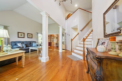
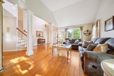
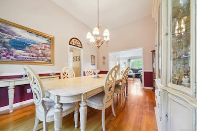
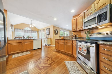
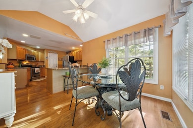
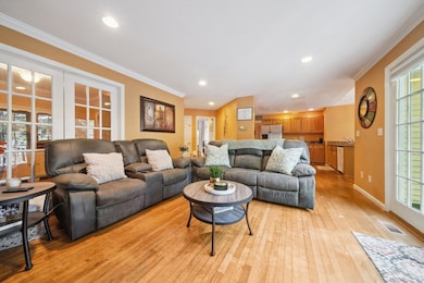
So Much More Than Meets the Eye! Sought after Cranbury neighborhood Colonial with well over 3,000 sq. ft. of finished living space, offering plenty of room for everyone. The first floor has a comfortable flow from front entry foyer into the living room, formal dining room, and kitchen, leading way to the family room and out to the back deck and yard, making it easy to gather and entertain. A home office or den with direct access to the two-car garage adds convenience for today's busy lifestyles. Upstairs, you will find a primary suite, three additional bedrooms, and laundry access right where you need it. The finished walk-out lower level is full of possibilities featuring a separate room that can serve as a bedroom (or extra home office), a half bath with room to expand into a full bath, and access to the rear yard and patio (in-law apt/au-pair potential). Three zone heating, many mechanical updates and a two year old roof, giving peace of mind. The location couldn't be better! Walk to Cranbury Market and neighborhood shops, with easy access to the Merritt Parkway, I-95, and the Route 7 connector. Close to the Wilton and Westport lines as well; you'll have shopping, dining, and family activities just minutes away. Don't let this wonderful opportunity pass you by.
Listing Agent
William Raveis Real Estate Brokerage Phone: (203) 257-2412 License #RES.0768975 Listed on: 09/28/2025

Home Details
Home Type
- Single Family
Est. Annual Taxes
- $13,723
Year Built
- Built in 1997
Lot Details
- 0.31 Acre Lot
- Partially Wooded Lot
- Property is zoned A1
Home Design
- Colonial Architecture
- Concrete Foundation
- Frame Construction
- Asphalt Shingled Roof
- Wood Siding
Interior Spaces
- 2,607 Sq Ft Home
- Central Vacuum
- 1 Fireplace
- Pull Down Stairs to Attic
Kitchen
- Oven or Range
- Microwave
- Dishwasher
Bedrooms and Bathrooms
- 4 Bedrooms
Laundry
- Laundry on upper level
- Dryer
- Washer
Finished Basement
- Walk-Out Basement
- Basement Fills Entire Space Under The House
- Basement Storage
Parking
- 2 Car Garage
- Parking Deck
- Automatic Garage Door Opener
Outdoor Features
- Beach Access
- Deck
- Patio
Location
- Property is near shops
Schools
- Cranbury Elementary School
- West Rocks Middle School
- Norwalk High School
Utilities
- Central Air
- Heating System Uses Oil
- Oil Water Heater
- Fuel Tank Located in Basement
Listing and Financial Details
- Assessor Parcel Number 243138
Map
Home Values in the Area
Average Home Value in this Area
Tax History
| Year | Tax Paid | Tax Assessment Tax Assessment Total Assessment is a certain percentage of the fair market value that is determined by local assessors to be the total taxable value of land and additions on the property. | Land | Improvement |
|---|---|---|---|---|
| 2025 | $13,723 | $573,090 | $185,650 | $387,440 |
| 2024 | $13,520 | $573,090 | $185,650 | $387,440 |
| 2023 | $10,847 | $431,120 | $147,980 | $283,140 |
| 2022 | $10,645 | $431,120 | $147,980 | $283,140 |
| 2021 | $10,368 | $431,120 | $147,980 | $283,140 |
| 2020 | $10,363 | $431,120 | $147,980 | $283,140 |
| 2019 | $10,073 | $431,120 | $147,980 | $283,140 |
| 2018 | $11,116 | $416,930 | $151,740 | $265,190 |
| 2017 | $10,734 | $416,930 | $151,740 | $265,190 |
| 2016 | $10,632 | $416,930 | $151,740 | $265,190 |
| 2015 | $10,603 | $416,930 | $151,740 | $265,190 |
| 2014 | $10,465 | $416,930 | $151,740 | $265,190 |
Property History
| Date | Event | Price | List to Sale | Price per Sq Ft |
|---|---|---|---|---|
| 12/03/2025 12/03/25 | Price Changed | $969,000 | -2.0% | $372 / Sq Ft |
| 10/03/2025 10/03/25 | For Sale | $989,000 | -- | $379 / Sq Ft |
Purchase History
| Date | Type | Sale Price | Title Company |
|---|---|---|---|
| Warranty Deed | $768,000 | -- | |
| Warranty Deed | $768,000 | -- | |
| Warranty Deed | $380,000 | -- | |
| Warranty Deed | $380,000 | -- |
Mortgage History
| Date | Status | Loan Amount | Loan Type |
|---|---|---|---|
| Open | $135,800 | No Value Available | |
| Closed | $100,000 | No Value Available |
Source: SmartMLS
MLS Number: 24129813
APN: NORW-000005-000029-000072
Disclaimer: Certain information contained herein is derived from information provided by parties other than Homes.com. All information provided is deemed reliable, but is not guaranteed to be accurate and should be independently verified.
![]() IDX information is provided exclusively for personal, non-commercial use, and may not be used for any purpose other than to identify prospective properties consumers may be interested in purchasing. Information is deemed reliable but not guaranteed.
IDX information is provided exclusively for personal, non-commercial use, and may not be used for any purpose other than to identify prospective properties consumers may be interested in purchasing. Information is deemed reliable but not guaranteed.
- 8 Stonecrop Rd
- 101 Chestnut Hill Rd
- 27 Stonecrop Rd
- 41 Mohawk Dr
- 32 Thistle Rd
- 4 Newtown Turnpike
- 9 Trailside Dr
- 2 Wildgoose Ln
- 56 Partrick Rd
- 57 Partrick Rd
- 7 Peaceful Ln
- 180 E Rocks Rd
- 3 Tanglewood Ln
- 33 Pequot Trail
- 9 Allen Ct
- 30 Honeysuckle Dr
- 13 Orchard Hill Rd
- 142 Wolfpit Ave
- 33 Assisi Way
- 29 Saddle Rd
- 14 White Barns Ln Unit 14
- 29 Saddle Rd
- 259 Wilton Rd
- 597 Westport Ave
- 1 Kittredge St
- 10 Willard Rd Unit 107
- 41 Wolfpit Ave
- 63 Kings Hwy N
- 10 Willard Rd
- 96 Kings Hwy N
- 1118 Foxboro Dr
- 2 Visconti St
- 317 Strawberry Hill Ave
- 115 Wilton Rd Unit 2
- 664 Main Ave Unit 302
- 130 Post Rd W Unit Penthouse
- 41 Richmondville Ave Unit 209
- 71 Aiken St Unit B 3
- 400 Main Ave
- 26 Fawn Ridge Ln