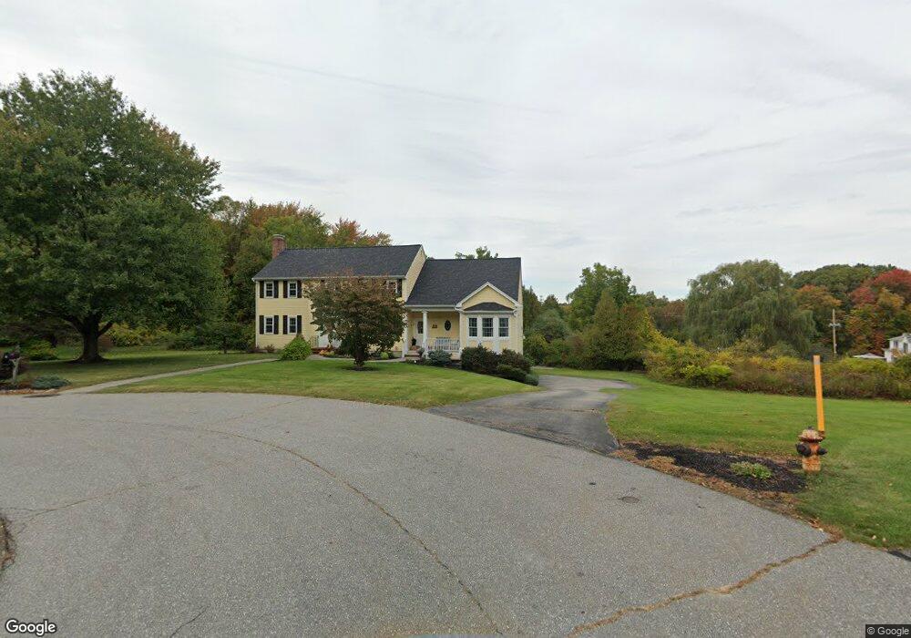
4 Fun Flight Cir Andover, MA 01810
Far West Andover NeighborhoodEstimated Value: $1,016,000 - $1,364,000
4
Beds
3
Baths
3,467
Sq Ft
$341/Sq Ft
Est. Value
About This Home
This home is located at 4 Fun Flight Cir, Andover, MA 01810 and is currently estimated at $1,182,876, approximately $341 per square foot. 4 Fun Flight Cir is a home located in Essex County with nearby schools including High Plain Elementary School, Wood Hill Middle School, and Andover High School.
Ownership History
Date
Name
Owned For
Owner Type
Purchase Details
Closed on
Sep 4, 2018
Sold by
Hunter Michael P and Hunter Susan B
Bought by
4 Fun Flight Circle Rt
Current Estimated Value
Purchase Details
Closed on
Apr 27, 1990
Sold by
Castle Green Dev Assoc
Bought by
Hunter Michael P
Create a Home Valuation Report for This Property
The Home Valuation Report is an in-depth analysis detailing your home's value as well as a comparison with similar homes in the area
Home Values in the Area
Average Home Value in this Area
Purchase History
We collect this data history from publicly available records. To have your information removed, we recommend requesting removal directly through your county’s website.
| Date | Buyer | Sale Price | Title Company |
|---|---|---|---|
| 4 Fun Flight Circle Rt | -- | -- | |
| Hunter Michael P | $218,700 | -- |
Source: Public Records
Mortgage History
We collect this data history from publicly available records. To have your information removed, we recommend requesting removal directly through your county’s website.
| Date | Status | Borrower | Loan Amount |
|---|---|---|---|
| Previous Owner | Hunter Michael P | $160,000 | |
| Previous Owner | Hunter Michael P | $130,000 | |
| Previous Owner | Hunter Michael P | $176,000 |
Source: Public Records
Tax History
| Year | Tax Paid | Tax Assessment Tax Assessment Total Assessment is a certain percentage of the fair market value that is determined by local assessors to be the total taxable value of land and additions on the property. | Land | Improvement |
|---|---|---|---|---|
| 2025 | $11,422 | $914,500 | $393,200 | $521,300 |
| 2024 | $11,030 | $856,400 | $373,600 | $482,800 |
| 2023 | $10,354 | $758,000 | $319,600 | $438,400 |
| 2022 | $9,932 | $680,300 | $288,300 | $392,000 |
| 2021 | $9,539 | $623,900 | $262,100 | $361,800 |
| 2020 | $9,282 | $618,400 | $262,100 | $356,300 |
| 2019 | $9,248 | $605,600 | $254,700 | $350,900 |
| 2018 | $8,945 | $571,900 | $247,300 | $324,600 |
| 2017 | $8,599 | $566,500 | $242,500 | $324,000 |
| 2016 | $8,430 | $568,800 | $242,500 | $326,300 |
| 2015 | $8,259 | $551,700 | $242,500 | $309,200 |
Source: Public Records
Map
Nearby Homes
- 7 Westwood Terrace
- 117 Pearl St
- 2 Weeping Willow Dr
- 2 Andover Terrace
- 0 Hudson Ave
- 13 Caswell Ave
- 90 Beacon St Unit 12
- 312 Water St Unit 33
- 110-112 Everett St
- 100 Hancock St
- 8 Brundrett Ave
- 82-84 Haverhill St
- 8 Glen Forest Ln
- 14 Samos Ln
- 2 Dove Ln Unit 2
- 11 Swan Ln Unit 11
- 4 Bicknell Terrace
- 11 Crescent St
- 14 Tyler St Unit 1
- 15 Crescent St Unit D
- 3 Fun Flight Cir
- 26 River Rd
- 2 Fun Flight Cir
- 24 River Rd
- 1 Fun Flight Cir
- 117 North St
- 18 River Rd
- 119 North St
- 29 River Rd
- 27 River Rd
- 107 North St
- 32 River Rd
- 14 River Rd
- 123 North St
- 31 River Rd
- 21 Webster St
- 103 North St
- 1202 Spring Valley Dr
- 1201 Spring Valley Dr
- 1201 Spring Valley Dr Unit 1201
Your Personal Tour Guide
Ask me questions while you tour the home.