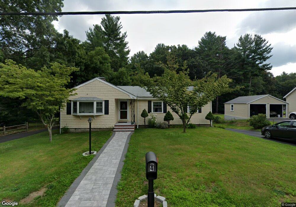
4 Gowing Rd Wilmington, MA 01887
Estimated Value: $625,000 - $770,908
4
Beds
2
Baths
1,538
Sq Ft
$471/Sq Ft
Est. Value
About This Home
This home is located at 4 Gowing Rd, Wilmington, MA 01887 and is currently estimated at $724,477, approximately $471 per square foot. 4 Gowing Rd is a home located in Middlesex County with nearby schools including Wilmington Middle School, Wilmington High School, and N Reading Knowledge Beginnings.
Ownership History
Date
Name
Owned For
Owner Type
Purchase Details
Closed on
Mar 28, 2003
Sold by
Derrico Anna Est
Bought by
Pandya Dhara N
Current Estimated Value
Home Financials for this Owner
Home Financials are based on the most recent Mortgage that was taken out on this home.
Original Mortgage
$220,000
Outstanding Balance
$95,620
Interest Rate
5.91%
Mortgage Type
Purchase Money Mortgage
Estimated Equity
$628,857
Create a Home Valuation Report for This Property
The Home Valuation Report is an in-depth analysis detailing your home's value as well as a comparison with similar homes in the area
Home Values in the Area
Average Home Value in this Area
Purchase History
| Date | Buyer | Sale Price | Title Company |
|---|---|---|---|
| Pandya Dhara N | $275,000 | -- |
Source: Public Records
Mortgage History
| Date | Status | Borrower | Loan Amount |
|---|---|---|---|
| Open | Pandya Dhara N | $220,000 |
Source: Public Records
Tax History Compared to Growth
Tax History
| Year | Tax Paid | Tax Assessment Tax Assessment Total Assessment is a certain percentage of the fair market value that is determined by local assessors to be the total taxable value of land and additions on the property. | Land | Improvement |
|---|---|---|---|---|
| 2025 | $7,523 | $657,000 | $319,400 | $337,600 |
| 2024 | $7,173 | $627,600 | $319,400 | $308,200 |
| 2023 | $6,965 | $583,300 | $290,200 | $293,100 |
| 2022 | $6,636 | $509,300 | $241,900 | $267,400 |
| 2021 | $6,718 | $485,400 | $219,900 | $265,500 |
| 2020 | $6,505 | $479,000 | $219,900 | $259,100 |
| 2019 | $6,516 | $473,900 | $209,500 | $264,400 |
| 2018 | $6,018 | $417,600 | $199,500 | $218,100 |
| 2017 | $5,686 | $393,500 | $199,500 | $194,000 |
| 2016 | $5,622 | $384,300 | $189,900 | $194,400 |
| 2015 | $5,291 | $368,200 | $189,900 | $178,300 |
| 2014 | $5,051 | $354,700 | $180,800 | $173,900 |
Source: Public Records
Map
Nearby Homes
- 7 W Village Dr
- 12 Lockwood Rd
- 5 Flynn Way
- 220 Martins Landing Unit 309
- 260 Martins Landing Unit 508
- 260 Martins Landing Unit 103
- 300 Martins Landing Unit 107
- 320 Martins Landing Unit 108
- 320 Martins Landing Unit 109
- 320 Martins Landing Unit 110
- 320 Martins Landing Unit 303
- 320 Martins Landing Unit 102
- 320 Martins Landing Unit 103
- 320 Martins Landing Unit 2410
- 320 Martins Landing Unit 403
- 320 Martins Landing Unit 2201
- 320 Martins Landing Unit 112
- 320 Martins Landing Unit 206
- 320 Martins Landing Unit 2307
- 320 Martins Landing Unit 302