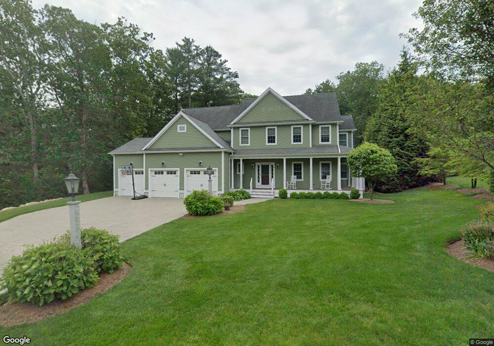
4 Harvey Ln North Easton, MA 02356
Estimated Value: $1,091,000 - $1,362,000
4
Beds
4
Baths
3,456
Sq Ft
$364/Sq Ft
Est. Value
About This Home
This home is located at 4 Harvey Ln, North Easton, MA 02356 and is currently estimated at $1,259,478, approximately $364 per square foot. 4 Harvey Ln is a home located in Bristol County with nearby schools including Easton Middle School.
Ownership History
Date
Name
Owned For
Owner Type
Purchase Details
Closed on
Jul 29, 2014
Sold by
Dkw Builders Inc
Bought by
West Rt and Mone
Current Estimated Value
Purchase Details
Closed on
Aug 30, 2013
Sold by
Dkw Builders Inc
Bought by
Resca Michael J and Resca Lisa S
Home Financials for this Owner
Home Financials are based on the most recent Mortgage that was taken out on this home.
Original Mortgage
$417,000
Interest Rate
4.4%
Mortgage Type
New Conventional
Purchase Details
Closed on
Mar 28, 2013
Sold by
Dkw Builders Inc
Bought by
Grantee West Rt and Mone
Home Financials for this Owner
Home Financials are based on the most recent Mortgage that was taken out on this home.
Original Mortgage
$350,000
Interest Rate
3.56%
Mortgage Type
New Conventional
Create a Home Valuation Report for This Property
The Home Valuation Report is an in-depth analysis detailing your home's value as well as a comparison with similar homes in the area
Home Values in the Area
Average Home Value in this Area
Purchase History
| Date | Buyer | Sale Price | Title Company |
|---|---|---|---|
| West Rt | $710,750 | -- | |
| West Rt | $710,750 | -- | |
| Resca Michael J | $710,750 | -- | |
| Resca Michael J | $710,750 | -- | |
| Grantee West Rt | -- | -- | |
| Grantee West Rt | -- | -- | |
| Grantee West Rt | -- | -- |
Source: Public Records
Mortgage History
| Date | Status | Borrower | Loan Amount |
|---|---|---|---|
| Previous Owner | Resca Michael J | $417,000 | |
| Previous Owner | Grantee West Rt | $350,000 |
Source: Public Records
Tax History Compared to Growth
Tax History
| Year | Tax Paid | Tax Assessment Tax Assessment Total Assessment is a certain percentage of the fair market value that is determined by local assessors to be the total taxable value of land and additions on the property. | Land | Improvement |
|---|---|---|---|---|
| 2025 | $15,026 | $1,204,000 | $457,500 | $746,500 |
| 2024 | $15,114 | $1,132,100 | $390,800 | $741,300 |
| 2023 | $14,158 | $970,400 | $375,200 | $595,200 |
| 2022 | $13,522 | $878,600 | $305,000 | $573,600 |
| 2021 | $13,181 | $851,500 | $277,900 | $573,600 |
| 2020 | $12,847 | $835,300 | $277,900 | $557,400 |
| 2019 | $13,245 | $829,900 | $277,900 | $552,000 |
| 2018 | $12,843 | $792,300 | $285,300 | $507,000 |
| 2017 | $12,296 | $758,100 | $285,300 | $472,800 |
| 2016 | $11,940 | $737,500 | $297,700 | $439,800 |
| 2015 | $11,385 | $678,500 | $238,700 | $439,800 |
| 2014 | $6,727 | $404,000 | $245,600 | $158,400 |
Source: Public Records
Map
Nearby Homes
- 175 N Main St
- 93 Palisades Cir
- 12 Holmes St
- 15 King Ave
- 1600 West St
- 8 Hobart Way
- 11 Olde Stable Ln
- 1 Whittier Ln Unit 1
- 18 Prudence Crandall Ln Unit 18
- 4 Eagle Rock Rd
- Lot 8 Cooper Ln
- 224 Main St
- 225 Main St
- 14 Marshall Rd
- 67 Center St
- 56 Williams St
- 86 Union St
- 110 Union St
- 334-336 Main St
- Lot 1 Winterberry Ln