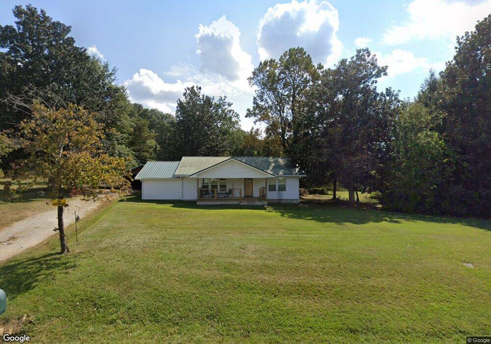
4 Hosey Rd Bowdon, GA 30108
Estimated Value: $210,357 - $257,000
3
Beds
1
Bath
1,512
Sq Ft
$157/Sq Ft
Est. Value
About This Home
This home is located at 4 Hosey Rd, Bowdon, GA 30108 and is currently estimated at $237,339, approximately $156 per square foot. 4 Hosey Rd is a home located in Carroll County with nearby schools including Bowdon Elementary School, Bowdon Middle School, and Bowdon High School.
Ownership History
Date
Name
Owned For
Owner Type
Purchase Details
Closed on
Jul 21, 2024
Sold by
Carroll William R
Bought by
Wt Carroll Investments Llc
Current Estimated Value
Purchase Details
Closed on
May 28, 2024
Sold by
Hosey Holly
Bought by
Arroll William R
Purchase Details
Closed on
May 21, 2007
Sold by
Greene Phyllis C Hosey Estate
Bought by
Greene Thomas R
Purchase Details
Closed on
Jun 26, 2006
Sold by
Not Provided
Bought by
Hosey Hurtis R
Purchase Details
Closed on
Nov 30, 2001
Sold by
Hosey Dorothy Louise
Bought by
Greene Phyllis C Hos
Purchase Details
Closed on
Nov 3, 1994
Sold by
Hosey
Bought by
Hosey Dorothy Louise
Purchase Details
Closed on
May 28, 1957
Bought by
Hosey
Create a Home Valuation Report for This Property
The Home Valuation Report is an in-depth analysis detailing your home's value as well as a comparison with similar homes in the area
Home Values in the Area
Average Home Value in this Area
Purchase History
| Date | Buyer | Sale Price | Title Company |
|---|---|---|---|
| Wt Carroll Investments Llc | -- | -- | |
| Arroll William R | $60,000 | -- | |
| Greene Thomas R | -- | -- | |
| Hosey Hurtis R | -- | -- | |
| Greene Phyllis C Hos | -- | -- | |
| Hosey Dorothy Louise | -- | -- | |
| Hosey | -- | -- |
Source: Public Records
Tax History Compared to Growth
Tax History
| Year | Tax Paid | Tax Assessment Tax Assessment Total Assessment is a certain percentage of the fair market value that is determined by local assessors to be the total taxable value of land and additions on the property. | Land | Improvement |
|---|---|---|---|---|
| 2024 | $1,232 | $54,446 | $7,087 | $47,359 |
| 2023 | $1,232 | $48,768 | $5,670 | $43,098 |
| 2022 | $970 | $38,678 | $3,780 | $34,898 |
| 2021 | $846 | $32,982 | $3,024 | $29,958 |
| 2020 | $760 | $29,599 | $2,749 | $26,850 |
| 2019 | $696 | $26,911 | $2,749 | $24,162 |
| 2018 | $635 | $24,182 | $2,749 | $21,433 |
| 2017 | $637 | $24,182 | $2,749 | $21,433 |
| 2016 | $637 | $24,182 | $2,749 | $21,433 |
| 2015 | $429 | $15,339 | $3,582 | $11,757 |
| 2014 | $431 | $15,339 | $3,582 | $11,757 |
Source: Public Records
Map
Nearby Homes
- 0 Stateline Rd Unit 21555538
- 0 Ayers Rd Unit 148384
- 0 Ayers Rd Unit 10639511
- 0 Ayers Rd Unit 7678056
- 1254 Ayers Rd
- 2875 W Highway 166
- 2961 W Highway 166
- 2140 W Highway 166
- 1195 Watts Rd
- 81 1st Ave N
- 746 Dot Rd
- 0 W Highway 166 Unit 10593828
- 0 W Highway 166 Unit 82 148167
- 0 W Highway 166 Unit 148352
- 1770 Georgia 100
- 110 Bartlett Cir
- 1794 Georgia 100
- 710 Mitchell Ave
- 1871 Sandy Flat Rd
- 56 Hosey Rd
- 1781 Sandy Flat Rd
- 49 Hosey Rd
- 1887 Sandy Flat Rd
- 1776 Sandy Flat Rd
- 1920 Sandy Flat Rd
- 1715 Sandy Flat Rd
- 1695 Sandy Flat Rd
- 2070 County Road 28
- 2014 Sandy Flat Rd
- 1969 County Road 23
- 2077 County Road 28
- 1670 Sandy Flat Rd
- 1742 Sandy Flat Rd
- 1918 County Road 23
- 1898 County Road 23
- 1898 County Road 23
- 2449 Stateline Rd
- 2031 Sandy Flat Rd