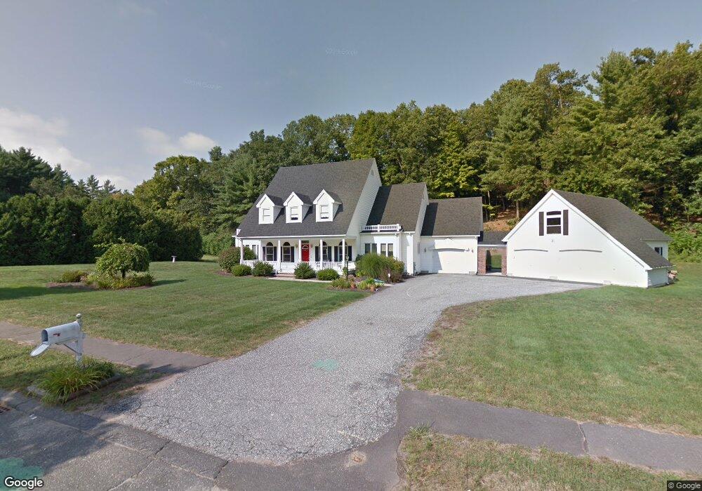
4 Labrie Ln Holyoke, MA 01040
Estimated Value: $665,273 - $814,000
4
Beds
3
Baths
3,426
Sq Ft
$212/Sq Ft
Est. Value
About This Home
This home is located at 4 Labrie Ln, Holyoke, MA 01040 and is currently estimated at $725,758, approximately $211 per square foot. 4 Labrie Ln is a home located in Hampden County with nearby schools including Lt. Elmer J. McMahon Elementary School, Lt. Clayre Sullivan Elementary School, and Holyoke High School.
Ownership History
Date
Name
Owned For
Owner Type
Purchase Details
Closed on
Mar 11, 2003
Sold by
Portno Barbara and Portno Michael E
Bought by
Caligaris Gail T and Caligaris John M
Current Estimated Value
Home Financials for this Owner
Home Financials are based on the most recent Mortgage that was taken out on this home.
Original Mortgage
$304,000
Interest Rate
5.95%
Mortgage Type
Purchase Money Mortgage
Purchase Details
Closed on
May 29, 1991
Sold by
Wohlers Curtiss G
Bought by
Portno Michael E
Purchase Details
Closed on
Feb 15, 1991
Sold by
Labrie Robert D and Labrie Marie
Bought by
Wohlers Curtiss G
Create a Home Valuation Report for This Property
The Home Valuation Report is an in-depth analysis detailing your home's value as well as a comparison with similar homes in the area
Home Values in the Area
Average Home Value in this Area
Purchase History
| Date | Buyer | Sale Price | Title Company |
|---|---|---|---|
| Caligaris Gail T | $389,900 | -- | |
| Portno Michael E | $26,000 | -- | |
| Wohlers Curtiss G | $22,000 | -- |
Source: Public Records
Mortgage History
| Date | Status | Borrower | Loan Amount |
|---|---|---|---|
| Open | Wohlers Curtiss G | $171,450 | |
| Open | Wohlers Curtiss G | $304,700 | |
| Closed | Caligaris Gail T | $304,000 |
Source: Public Records
Tax History
| Year | Tax Paid | Tax Assessment Tax Assessment Total Assessment is a certain percentage of the fair market value that is determined by local assessors to be the total taxable value of land and additions on the property. | Land | Improvement |
|---|---|---|---|---|
| 2025 | $10,684 | $611,900 | $99,900 | $512,000 |
| 2024 | $10,386 | $548,100 | $95,100 | $453,000 |
| 2023 | $9,898 | $527,600 | $95,100 | $432,500 |
| 2022 | $9,513 | $493,900 | $95,100 | $398,800 |
| 2021 | $9,332 | $478,600 | $95,100 | $383,500 |
| 2020 | $8,718 | $456,900 | $95,100 | $361,800 |
| 2019 | $8,781 | $455,200 | $95,100 | $360,100 |
| 2018 | $3,142 | $436,400 | $95,100 | $341,300 |
| 2017 | $8,366 | $436,400 | $95,100 | $341,300 |
| 2016 | $7,384 | $386,200 | $98,100 | $288,100 |
| 2015 | $7,353 | $386,200 | $98,100 | $288,100 |
Source: Public Records
Map
Nearby Homes
Your Personal Tour Guide
Ask me questions while you tour the home.