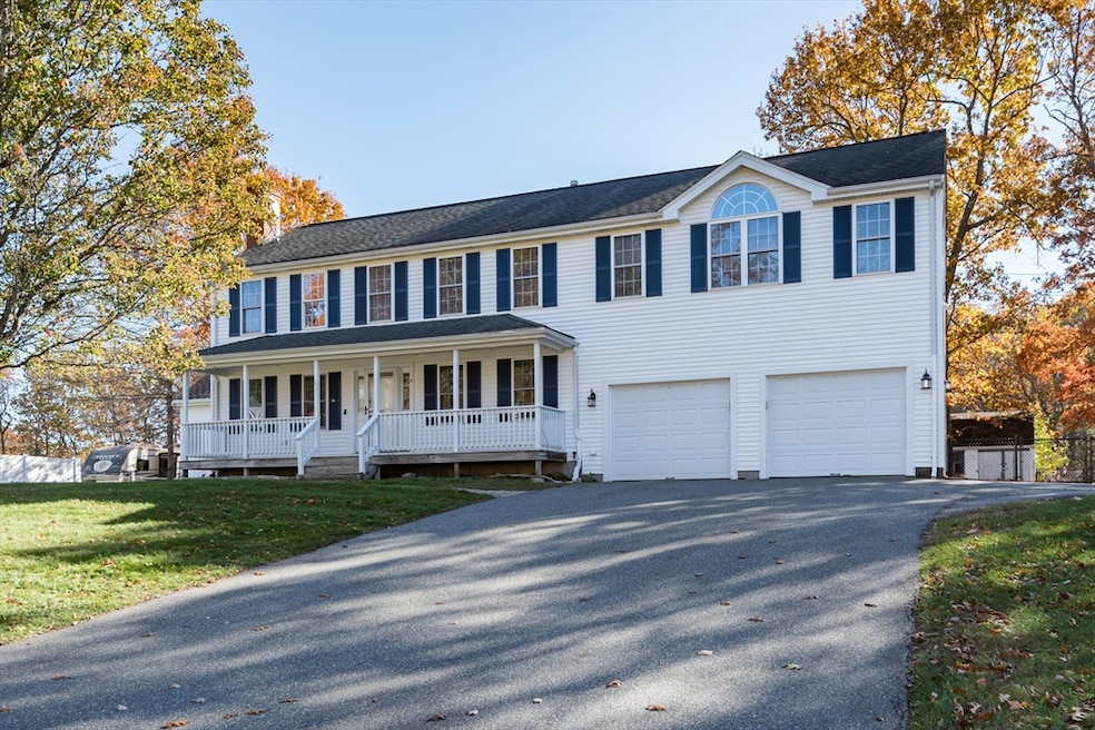
4 Locust Hill Ln Whitman, MA 02382
Estimated payment $4,663/month
Highlights
- Golf Course Community
- Medical Services
- Colonial Architecture
- Community Stables
- 1.4 Acre Lot
- Deck
About This Home
*Price Enhancement* Welcome to this Beautiful 4-bedroom, 2.5-bath Colonial, ideally located in a peaceful and highly sought-after neighborhood. This spacious home features a 2-car garage with the main bedroom suite located above, featuring its own sitting area & full bath for added comfort & privacy. The main level boasts refinished hardwood floors in the living & dining room. A large, inviting family room off the kitchen - perfect for entertaining family, friends, & new neighbors, w/half bath & interior access to the garage. Upstairs, you’ll find 3 more bedrooms and an additional full bathroom ideal for family or guests. Carpets need to be replaced. Full basement provides additional living space, a home office or gym. Step outside to enjoy the level, fenced -in backyard, ideal for outdoor activities, pets and relaxation. A wired storage shed adds funcitionality for hobbies/tools. Nearby Commuter rail, great restaurants, a beautiful park, and walking trails nearby.
Home Details
Home Type
- Single Family
Est. Annual Taxes
- $8,876
Year Built
- Built in 2001
Lot Details
- 1.4 Acre Lot
- Cul-De-Sac
- Level Lot
- Property is zoned A1
Parking
- 2 Car Attached Garage
- Driveway
- Open Parking
Home Design
- Colonial Architecture
- Frame Construction
- Shingle Roof
- Concrete Perimeter Foundation
Interior Spaces
- 2,620 Sq Ft Home
- Cathedral Ceiling
- Ceiling Fan
- Skylights
- Recessed Lighting
- Light Fixtures
- Living Room with Fireplace
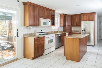
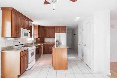
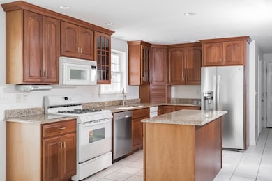
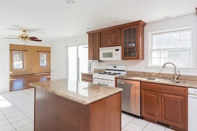
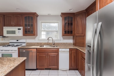
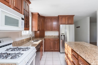
Kitchen
- Range
- Dishwasher
- Kitchen Island
- Solid Surface Countertops
- Trash Compactor
Flooring
- Wood
- Wall to Wall Carpet
- Laminate
- Ceramic Tile
Bedrooms and Bathrooms
- 4 Bedrooms
- Primary bedroom located on second floor
- Dual Closets
- Walk-In Closet
- Bathtub with Shower
Laundry
- Dryer
- Washer
Unfinished Basement
- Basement Fills Entire Space Under The House
- Sump Pump
- Block Basement Construction
Outdoor Features
- Bulkhead
- Balcony
- Deck
- Outdoor Storage
- Rain Gutters
- Porch
Location
- Property is near public transit
- Property is near schools
Schools
- Louise Conley Elementary School
- Whitman Middle School
- Whitman-Hanson High School
Utilities
- Forced Air Heating and Cooling System
- 2 Cooling Zones
- 2 Heating Zones
- Heating System Uses Natural Gas
- 200+ Amp Service
- Tankless Water Heater
- Gas Water Heater
- Internet Available
Listing and Financial Details
- Assessor Parcel Number M:019D B:0117 L:203,4322067
Community Details
Overview
- No Home Owners Association
- Near Conservation Area
Amenities
- Medical Services
- Shops
- Coin Laundry
Recreation
- Golf Course Community
- Tennis Courts
- Community Pool
- Park
- Community Stables
- Jogging Path
Map
Home Values in the Area
Average Home Value in this Area
Tax History
| Year | Tax Paid | Tax Assessment Tax Assessment Total Assessment is a certain percentage of the fair market value that is determined by local assessors to be the total taxable value of land and additions on the property. | Land | Improvement |
|---|---|---|---|---|
| 2025 | $8,876 | $676,500 | $264,600 | $411,900 |
| 2024 | $8,003 | $628,200 | $259,700 | $368,500 |
| 2023 | $7,823 | $576,500 | $227,100 | $349,400 |
| 2022 | $7,752 | $532,400 | $206,800 | $325,600 |
| 2021 | $7,550 | $487,100 | $188,800 | $298,300 |
| 2020 | $7,476 | $471,700 | $183,200 | $288,500 |
| 2019 | $7,181 | $466,900 | $183,200 | $283,700 |
| 2018 | $6,769 | $422,800 | $171,900 | $250,900 |
| 2017 | $6,376 | $422,800 | $171,900 | $250,900 |
| 2016 | $6,384 | $409,500 | $166,300 | $243,200 |
| 2015 | $6,392 | $409,500 | $166,300 | $243,200 |
Property History
| Date | Event | Price | List to Sale | Price per Sq Ft |
|---|---|---|---|---|
| 11/24/2025 11/24/25 | Pending | -- | -- | -- |
| 11/18/2025 11/18/25 | Price Changed | $745,000 | -3.9% | $284 / Sq Ft |
| 11/05/2025 11/05/25 | For Sale | $775,000 | -- | $296 / Sq Ft |
Purchase History
| Date | Type | Sale Price | Title Company |
|---|---|---|---|
| Deed | $311,600 | -- |
Mortgage History
| Date | Status | Loan Amount | Loan Type |
|---|---|---|---|
| Open | $25,000 | No Value Available | |
| Open | $100,000 | Purchase Money Mortgage |
Source: MLS Property Information Network (MLS PIN)
MLS Number: 73450276
APN: WHIT-000019D-000117-000203
Disclaimer: Certain information contained herein is derived from information provided by parties other than Homes.com. All information provided is deemed reliable, but is not guaranteed to be accurate and should be independently verified.
![]() The property listing data and information, or the Images, set forth herein were provided to MLS Property Information Network, Inc. from third party sources, including sellers, lessors and public records, and were compiled by MLS Property Information Network, Inc. The property listing data and information, and the Images, are for the personal, non-commercial use of consumers having a good faith interest in purchasing or leasing listed properties of the type displayed to them and may not be used for any purpose other than to identify prospective properties which such consumers may have a good faith interest in purchasing or leasing. MLS Property Information Network, Inc. and its subscribers disclaim any and all representations and warranties as to the accuracy of the property listing data and information, or as to the accuracy of any of the Images, set forth herein.
The property listing data and information, or the Images, set forth herein were provided to MLS Property Information Network, Inc. from third party sources, including sellers, lessors and public records, and were compiled by MLS Property Information Network, Inc. The property listing data and information, and the Images, are for the personal, non-commercial use of consumers having a good faith interest in purchasing or leasing listed properties of the type displayed to them and may not be used for any purpose other than to identify prospective properties which such consumers may have a good faith interest in purchasing or leasing. MLS Property Information Network, Inc. and its subscribers disclaim any and all representations and warranties as to the accuracy of the property listing data and information, or as to the accuracy of any of the Images, set forth herein.
- 63 Rice St
- 360 High St
- 63 Allen St
- 14 Doris Dr
- 33 Green St
- 300 High St
- 11 Glenwood St
- 32 Joyce Terrace
- 877 Brockton Ave Unit 877
- 16 Davis St
- 93 Porter St
- 66 Belmont St
- 967 Centre St
- 1098 Bedford St
- 34 George h Gillespie Way
- 1024 Crescent St
- 104 Crestfield Dr
- 922 Centre St
- 59 Sharon St
- 193 Linwood St
