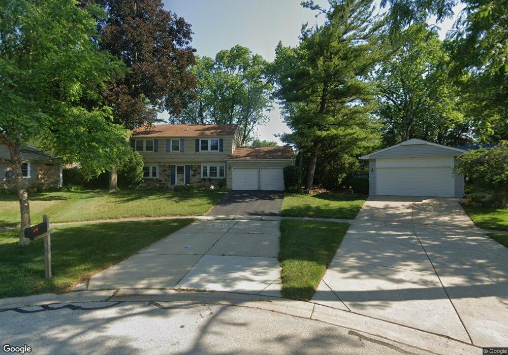
4 Longwood Ct Buffalo Grove, IL 60089
South Buffalo Grove NeighborhoodEstimated Value: $444,940 - $484,000
4
Beds
2
Baths
1,578
Sq Ft
$295/Sq Ft
Est. Value
About This Home
This home is located at 4 Longwood Ct, Buffalo Grove, IL 60089 and is currently estimated at $464,985, approximately $294 per square foot. 4 Longwood Ct is a home located in Cook County with nearby schools including Henry W Longfellow Elementary School, Cooper Middle School, and Buffalo Grove High School.
Ownership History
Date
Name
Owned For
Owner Type
Purchase Details
Closed on
Mar 9, 2017
Sold by
Blankshain Alan R and Blankshain Linda H
Bought by
Blankshain Alan R and Blankshain Linda H
Current Estimated Value
Purchase Details
Closed on
Sep 1, 1994
Sold by
Lenz John W and Lenz Carol J
Bought by
Blankshain Alan R and Blankshain Linda H
Home Financials for this Owner
Home Financials are based on the most recent Mortgage that was taken out on this home.
Original Mortgage
$180,000
Interest Rate
8.65%
Create a Home Valuation Report for This Property
The Home Valuation Report is an in-depth analysis detailing your home's value as well as a comparison with similar homes in the area
Home Values in the Area
Average Home Value in this Area
Purchase History
| Date | Buyer | Sale Price | Title Company |
|---|---|---|---|
| Blankshain Alan R | -- | Attorney | |
| Blankshain Alan R | $260,000 | Attorneys Title Guaranty Fun |
Source: Public Records
Mortgage History
| Date | Status | Borrower | Loan Amount |
|---|---|---|---|
| Closed | Blankshain Alan R | $180,000 |
Source: Public Records
Tax History Compared to Growth
Tax History
| Year | Tax Paid | Tax Assessment Tax Assessment Total Assessment is a certain percentage of the fair market value that is determined by local assessors to be the total taxable value of land and additions on the property. | Land | Improvement |
|---|---|---|---|---|
| 2024 | $10,141 | $35,000 | $6,897 | $28,103 |
| 2023 | $9,724 | $35,000 | $6,897 | $28,103 |
| 2022 | $9,724 | $35,000 | $6,897 | $28,103 |
| 2021 | $9,308 | $29,677 | $4,406 | $25,271 |
| 2020 | $9,137 | $29,677 | $4,406 | $25,271 |
| 2019 | $9,125 | $32,902 | $4,406 | $28,496 |
| 2018 | $9,078 | $29,795 | $3,831 | $25,964 |
| 2017 | $8,931 | $29,795 | $3,831 | $25,964 |
| 2016 | $8,573 | $29,795 | $3,831 | $25,964 |
| 2015 | $7,710 | $25,317 | $3,256 | $22,061 |
| 2014 | $7,600 | $25,317 | $3,256 | $22,061 |
| 2013 | $7,007 | $25,317 | $3,256 | $22,061 |
Source: Public Records
Map
Nearby Homes
- 921 Bernard Dr
- 535 Estate Dr
- 571 Estate Dr
- 859 Beechwood Rd
- 720 Weidner Rd Unit 302
- 669 White Pine Rd
- 820 Weidner Rd Unit 4013
- 820 Weidner Rd Unit 409
- 705 Grove Dr Unit 101
- 665 Thornwood Dr
- 310 Rosewood Ave
- 715 W Whiting Ln
- 751 W Happfield Dr Unit 30
- 715 W Happfield Dr
- 812 W Whiting Ln
- 811 W Nichols Rd
- 3451 N Carriageway Dr Unit 503
- 18 E Heritage Ct
- 1112 Auburn Ln
- 1115 Miller Ln Unit 104